Store nearby סיטונאות רחמים
Israel
Store nearby סיטונאות רחמים
סיטונאות רחמים
Ashkelon, Israel
contacts phone
:
+972 8-672-8999
website:
m.facebook.com
Latitude:
31.6680646
, Longitude:
34.5574488
larger map & directions
read more
nearest Store
86 m
עידן חדש - רשת חנויות סלולר
שדרות דוד בן גוריון 5, אשקלון
Store
read more
207 m
Bake&Make
Shilo Street 1, Ashkelon
Store
read more
554 m
Deli-Cream
Ha-Nasi Street 97, Ashkelon
Store
read more
554 m
דלי קרים
חוףפ דלילה, אשקלון
Store
read more
761 m
קוקיגלידה
Ha-Gvura Street 3, Ashkelon
Store
read more
761 m
קוקיגלידה
הגבורה 3, אשקלון
Store
read more
813 m
Aroma Espresso Bar ארומה אספרסו בר
קניון גירון, שדרות דוד בן גוריון 21, אשקלון
Cafe
Food
Point of interest
Store
Establishment
read more
824 m
BestMobile (БестМобаил)
Sderot David Ben Gurion 21, Ashkelon
Store
read more
838 m
Kravitz
קניון גירון, שדרות בן גוריון 21, אשקלון
Store
read more
843 m
Yves Rocher
Sderot David Ben Gurion 21 Giron Mall, אשקלון
Store
read more
856 m
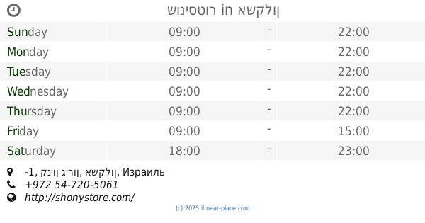
שוניסטור
קניון גירון קומה מינוס 1 כניסת רנואר - שדרות בן גוריון 10 טל' 053-3373271, אשקלון
Store
read more
863 m
אל טורו - קניון גירון
Ashkelon
Store
read more
863 m
Gethleman
Kibuts Galuyot Street 27, Ashkelon
Store
read more
863 m
אל טורו - קניון גירון
אשקלון
Store
read more
871 m
מאמא יוקרו
Kibuts Galuyot Street 27, Ashkelon
Store
read more
872 m
Greenhouse city
Ha-Gvura Street 11, Ashkelon
Store
read more
874 m
שוניסטור
קניון גירון, -1, אשקלון
Store
read more
877 m
Carolina Lemke - קניון גירון
קיבוץ גלויות 27, אשקלון
Store
read more
877 m
Carolina Lemke - קניון גירון
Kibuts Galuyot Street 27, Ashkelon
Store
read more
883 m
אופטיקנה - קניון גירון
Kibuts Galuyot Street 27, Ashkelon
Store
read more
884 m
TikVTik
Sderot David Ben Gurion 23, Ashkelon
Store
read more
884 m
TikVTik
שדרות דוד בן גוריון 23, אשקלון
Store
read more
918 m
סיטיפון
Sderot David Ben Gurion 25, Ashkelon
Store
read more
918 m
סיטיפון
שדרות דוד בן גוריון 25, אשקלון
Store
read more
1.01 km
Dream Catcher לוכד החולומות
sd. Ben-Gurion 29/8, Ashkelon
Store
read more
📑
all categories
Accounting
Administrative area level 1
Administrative area level 2
Airport
Amusement park
Aquarium
Art gallery
Atm
Bakery
Bank
Bar
Beauty salon
Bicycle store
Book store
Bowling alley
Bus station
Cafe
Campground
Car dealer
Car rental
Car repair
Car wash
Casino
Cemetery
Church
City hall
Clothing store
Colloquial area
Convenience store
Country
Courthouse
Dentist
Department store
Doctor
Electrician
Electronics store
Embassy
Establishment
Finance
Fire station
Florist
Food
Funeral home
Furniture store
Gas station
General contractor
Grocery or supermarket
Gym
Hair care
Hardware store
Health
Hindu Temple
Home goods store
Hospital
Insurance agency
Intersection
Jewelry store
Laundry
Lawyer
Library
Light rail station
Liquor store
Local government office
Locality
Locksmith
Lodging
Meal delivery
Meal takeaway
Mosque
Movie rental
Movie theater
Moving company
Museum
Natural feature
Neighborhood
Night club
Painter
Park
Parking
Pet store
Pharmacy
Physiotherapist
Place of worship
Plumber
Point of interest
Police
Political
Post office
Premise
Real estate agency
Restaurant
Roofing contractor
Route
Rv park, camping
School
Shoe store
Shopping mall
Spa
Stadium
Storage
Store
Subpremise
Subway station
Supermarket
Synagogue
Taxi stand
Train station
Transit station
Travel agency
University
Veterinary care
Zoo
administrative area level 3
administrative area level 4
sublocality level 1
↑