Store nearby שפע ברכת השם
Israel
Store nearby שפע ברכת השם
שפע ברכת השם
1, Shamai Street, 4082638, El'ad, Petach Tikva, IL Israel
contacts phone
:
+972 2-580-3849
Latitude:
32.050593
, Longitude:
34.950513
larger map & directions
read more
nearest Store
8 m
קיוסק של חגי
Shamai Street 1, El'ad
Store
read more
8 m
קיוסק של חגי
שמאי 1, אלעד
Store
read more
16 m
איכות השני
שמאי 1, אלעד
Store
read more
62 m
משכן התכלת
הלל 9, אלעד
Store
read more
62 m
משכן התכלת
Hillel Street 9, El'ad
Store
read more
148 m
על הדרך - חנות נוחות
Rabbi Yehuda HaNassi Street 31, El'ad
Lodging
Point of interest
Store
Establishment
read more
227 m
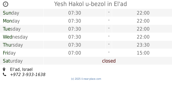
Yesh Hakol u-bezol
El'ad
Supermarket
Grocery or supermarket
Store
Food
Point of interest
Establishment
read more
272 m
מוליך סוכנויות - ציוד למאפיות וקונדיטוריות
Khoni ha-Me'agel Street 67, El'ad
Store
read more
288 m
I.s.m Elad
רבי עקיבא 1 בבית יד שרה, El'ad
Store
read more
288 m
ישמ
רבי עקיבא 1 בבית יד שרה, אלעד
Store
read more
540 m
דגל ניקוד והגהה
רשב"ם 5, אלעד
Store
read more
540 m
דגל ניקוד והגהה
Rashbam Street 5, El'ad
Store
read more
895 m
ברכל
Rabbi Pinhas Ben Yair Street 35, El'ad
Supermarket
Grocery or supermarket
Food
Store
Point of interest
Establishment
read more
959 m
אות וחותם חותמות
אבן גבירול 36, אלעד
Store
read more
959 m
אות וחותם חותמות
Ibn Gabirol Street 36, El'ad
Store
read more
960 m
אות וחותם
Ibn Gabirol Street 36, El'ad
Store
read more
960 m
אות וחותם
אבן גבירול 36, אלעד
Store
read more
980 m
אות וחותם , חותמות , שילוט לבית
Ibn Gabirol Street 21, El'ad
Store
read more
980 m
אות וחותם , חותמות , שילוט לבית
אבן גבירול 21, אלעד
Store
read more
1.017 km
Tefillin Yosef crown
Haran Street 18, El'ad
Store
read more
1.023 km
סת"ם למהדרין
רבי יהודה הנשיא 94, אלעד
Store
read more
1.023 km
טלית נאה
רבי יהודה הנשיא 94, אלעד
Store
read more
1.023 km
סתם למהדרין
Rabbi Yehuda HaNassi Street 94, El'ad
Store
read more
1.079 km
סים תקשורת
מרכז רימון, רבי שמעון בן שטח 8, אלעד
Store
read more
1.09 km
כפר השעשועים
מרכז רימון, רבי שמעון בן שטח 8, אלעד
Store
read more
📑
all categories
Accounting
Administrative area level 1
Administrative area level 2
Airport
Amusement park
Aquarium
Art gallery
Atm
Bakery
Bank
Bar
Beauty salon
Bicycle store
Book store
Bowling alley
Bus station
Cafe
Campground
Car dealer
Car rental
Car repair
Car wash
Casino
Cemetery
Church
City hall
Clothing store
Colloquial area
Convenience store
Country
Courthouse
Dentist
Department store
Doctor
Electrician
Electronics store
Embassy
Establishment
Finance
Fire station
Florist
Food
Funeral home
Furniture store
Gas station
General contractor
Grocery or supermarket
Gym
Hair care
Hardware store
Health
Hindu Temple
Home goods store
Hospital
Insurance agency
Intersection
Jewelry store
Laundry
Lawyer
Library
Light rail station
Liquor store
Local government office
Locality
Locksmith
Lodging
Meal delivery
Meal takeaway
Mosque
Movie rental
Movie theater
Moving company
Museum
Natural feature
Neighborhood
Night club
Painter
Park
Parking
Pet store
Pharmacy
Physiotherapist
Place of worship
Plumber
Point of interest
Police
Political
Post office
Premise
Real estate agency
Restaurant
Roofing contractor
Route
Rv park, camping
School
Shoe store
Shopping mall
Spa
Stadium
Storage
Store
Subpremise
Subway station
Supermarket
Synagogue
Taxi stand
Train station
Transit station
Travel agency
University
Veterinary care
Zoo
administrative area level 3
administrative area level 4
sublocality level 1
↑