Store nearby Rhythm
Israel
Store nearby Rhythm
Rhythm
Netanya, Israel
contacts phone
:
+972
Latitude:
32.2730124
, Longitude:
34.8337447
larger map & directions
read more
nearest Store
20 m
Bamboo Villiage Express
Netanya
Store
read more
20 m
Bamboo Villiage Express
נתניה
Store
read more
45 m
בסרף סנטר
נתניה
Store
read more
45 m
surf center poleg
Netanya
Store
read more
124 m
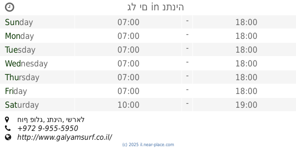
Gal Yam
חוף פולג, נתניה
Store
read more
124 m
גל ים
חוף פולג, נתניה
Store
read more
324 m
לגונה פולג
שולמית 3, Netanya
Store
read more
991 m
BAMBOO SURF-במבו סרף
חוף פולג, Netanya
Store
read more
1.005 km
On the Way to the Beach Cafe
Zalman Shazar Street 10, Netanya
Cafe
Food
Point of interest
Store
Establishment
read more
1.185 km
ואהבת
בני ברמן 2 , קניון עיר ימים, Netanya
Store
read more
1.22 km
שרונה - שמלות כלה תפירה אישית עד 3,800 שח
Uzi Hitman Street, Netanya
Store
read more
1.22 km
תוספי תזונה באיזור נתניה והסביבה - אבקות חלבון גיינרים לעליה במסה וויטמינים
עוזי חיטמן 9, Netanya
Store
read more
1.22 km
תוספי תזונה באיזור נתניה והסביבה - אבקות חלבון גיינרים לעליה במסה וויטמינים
עוזי חיטמן 9, נתניה
Store
read more
1.362 km
You And Eye
Beni Berman Street 2, Netanya
Store
read more
1.362 km
יו אנד אײ אופטיקה
בני ברמן 2, נתניה
Store
read more
1.38 km
אייקון
Beni Berman Street 2, Netanya
Store
read more
1.382 km
Тик Ха-Тиким
Beni Berman Street 2, Netanya
Store
read more
1.391 km
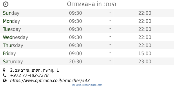
Оптикана
קניון עיר ימים, בני ברמן 2, נתניה
Store
read more
1.413 km
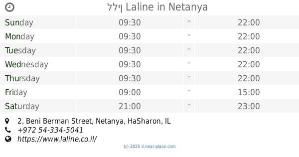
ללין Laline
Beni Berman Street 2, Netanya
Store
read more
1.414 km
Gaya
Beni Berman Street 2, Netanya
Store
read more
1.444 km
Rikushet
Beni Berman Street 2, Netanya
Store
read more
1.71 km
קופי צ'רס בעמ
ת.ד 344, Udim
Store
read more
1.761 km
Kazuma
HaHadarim Street 60, Udim
Store
read more
1.857 km
קרייזי לייק
שדרות גולדה מאיר 37, נתניה
Store
read more
2.03 km
פולג פארם
Sderot Pinhas Lavon 79-89, Netanya
Store
read more
📑
all categories
Accounting
Administrative area level 1
Administrative area level 2
Airport
Amusement park
Aquarium
Art gallery
Atm
Bakery
Bank
Bar
Beauty salon
Bicycle store
Book store
Bowling alley
Bus station
Cafe
Campground
Car dealer
Car rental
Car repair
Car wash
Casino
Cemetery
Church
City hall
Clothing store
Colloquial area
Convenience store
Country
Courthouse
Dentist
Department store
Doctor
Electrician
Electronics store
Embassy
Establishment
Finance
Fire station
Florist
Food
Funeral home
Furniture store
Gas station
General contractor
Grocery or supermarket
Gym
Hair care
Hardware store
Health
Hindu Temple
Home goods store
Hospital
Insurance agency
Intersection
Jewelry store
Laundry
Lawyer
Library
Light rail station
Liquor store
Local government office
Locality
Locksmith
Lodging
Meal delivery
Meal takeaway
Mosque
Movie rental
Movie theater
Moving company
Museum
Natural feature
Neighborhood
Night club
Painter
Park
Parking
Pet store
Pharmacy
Physiotherapist
Place of worship
Plumber
Point of interest
Police
Political
Post office
Premise
Real estate agency
Restaurant
Roofing contractor
Route
Rv park, camping
School
Shoe store
Shopping mall
Spa
Stadium
Storage
Store
Subpremise
Subway station
Supermarket
Synagogue
Taxi stand
Train station
Transit station
Travel agency
University
Veterinary care
Zoo
administrative area level 3
administrative area level 4
sublocality level 1
↑