Store nearby פיצוחי אבו ח'ליל טמרה
Israel
Store nearby פיצוחי אבו ח'ליל טמרה
פיצוחי אבו ח'ליל טמרה
Tamra, Israel
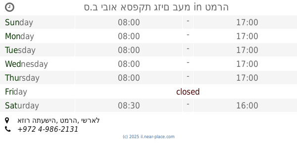
contacts phone
:
+972
Latitude:
32.8581386
, Longitude:
35.1845647
larger map & directions
read more
nearest Store
203 m
חשמל הגליל - كهرباء الجليل
רחוב בית ספר חקלאי, شارع المدرسة الزراعية, Tamra
Store
read more
203 m
חשמל הגליל
רחוב בית ספר חקלאי, شارع المدرسة الزراعية, Tamra
Store
read more
541 m
אלאנדלוס
Tamra
Store
read more
546 m
סיטי סטאר
Tamra
Store
read more
550 m
פון סנטר Phone Center
טמרה, כביש ראשי, Tamra
Store
read more
550 m
פון סנטר Phone Center
טמרה, כביש ראשי, טמרה
Store
read more
573 m
אופטיקה טמרה
Unnamed Road, טמרה
Store
read more
573 m
Tamra optics
Unnamed Road, Tamra
Store
read more
582 m
פרטנר
טמרה מול, טמרה
Store
read more
582 m
Service and Sales Center Tamra
טמרה מול, טמרה
Store
read more
583 m
Aoftiniis Tamra
טמרה מול, טמרה
Store
read more
587 m
سوبر ماركت ابناء مصطفى مواسي
ח'לית שריף/כניסה, Tamra
Supermarket
Grocery or supermarket
Store
Point of interest
Food
Establishment
read more
596 m
בית בד רומי המודרני
Tamra
Supermarket
Grocery or supermarket
Food
Point of interest
Store
Establishment
read more
631 m
الزيتونة Supermarket Bakery &more Alzytona
Tamra
Supermarket
Grocery or supermarket
Food
Store
Point of interest
Establishment
read more
648 m
Benny Abu Khalil Building Materials Ltd.
Tamra
Store
read more
668 m
משתלת ערין
Tamra
Store
read more
668 m
משתלת ערין
טמרה
Store
read more
786 m
מ.מ אבזרי רכב
Unnamed Rd, Tamra
Store
read more
923 m
سوبر ماركت اخوان سمار
Tamra
Supermarket
Grocery or supermarket
Store
Point of interest
Food
Establishment
read more
931 m
ס.ב יבוא אספקת גזים בעמ
אזור התעשיה, טמרה
Store
read more
933 m
רוני מארקית
Unnamed Road, Tamra
Cafe
Food
Point of interest
Store
Establishment
read more
1.093 km
Blinds Aldoha
Tamra
Store
read more
1.093 km
תריסי אלדוחא
טמרה
Store
read more
1.096 km
בשר טבעי
Tamra
Store
read more
1.174 km
rezek caffe
طمرة،
Cafe
Food
Point of interest
Store
Establishment
read more
📑
all categories
Accounting
Administrative area level 1
Administrative area level 2
Airport
Amusement park
Aquarium
Art gallery
Atm
Bakery
Bank
Bar
Beauty salon
Bicycle store
Book store
Bowling alley
Bus station
Cafe
Campground
Car dealer
Car rental
Car repair
Car wash
Casino
Cemetery
Church
City hall
Clothing store
Colloquial area
Convenience store
Country
Courthouse
Dentist
Department store
Doctor
Electrician
Electronics store
Embassy
Establishment
Finance
Fire station
Florist
Food
Funeral home
Furniture store
Gas station
General contractor
Grocery or supermarket
Gym
Hair care
Hardware store
Health
Hindu Temple
Home goods store
Hospital
Insurance agency
Intersection
Jewelry store
Laundry
Lawyer
Library
Light rail station
Liquor store
Local government office
Locality
Locksmith
Lodging
Meal delivery
Meal takeaway
Mosque
Movie rental
Movie theater
Moving company
Museum
Natural feature
Neighborhood
Night club
Painter
Park
Parking
Pet store
Pharmacy
Physiotherapist
Place of worship
Plumber
Point of interest
Police
Political
Post office
Premise
Real estate agency
Restaurant
Roofing contractor
Route
Rv park, camping
School
Shoe store
Shopping mall
Spa
Stadium
Storage
Store
Subpremise
Subway station
Supermarket
Synagogue
Taxi stand
Train station
Transit station
Travel agency
University
Veterinary care
Zoo
administrative area level 3
administrative area level 4
sublocality level 1
↑