Store nearby Play With
Israel
Store nearby Play With
Play With
אחד העם, רמת גן ישראל
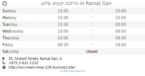
contacts phone
:
+972
Latitude:
32.0486282
, Longitude:
34.8190373
read more
nearest Store
Play With
Ahad Ha'Am Street, Ramat Gan
Store
read more
393 m
עולם פינוקי הגלידה
שלם 35, רמת גן
Store
read more
393 m
עולם פינוקי הגלידה
Shalem Street 35, Ramat Gan
Store
read more
400 m
כבאז - טל בעמ
שלם 33, רמת גן
Store
read more
400 m
Buzz - Tal Ltd.
Shalem Street 33, Ramat Gan
Store
read more
417 m
קסם הפרי והירק
Kikar HaRav Pardes, Ramat Gan
Store
read more
459 m
קוסמטיקאית ברמת גן - ענת בוארון
7ב, בני הנביאים, רמת גן
Store
read more
459 m
Beautician Ramat Gan - Anat Boaron
7ב, Bnei ha-Nevi'im Street, Ramat Gan
Store
read more
512 m
Knitting Studio - Trikotr jelly
Aluf David Street 171, Ramat Gan
Store
read more
512 m
סטודיו סריגה - טריקוטר קרושה
אלוף דוד 171, רמת גן
Store
read more
528 m
אטליז רוני טסה
שלם 12, רמת גן
Store
read more
528 m
אטליז רוני טסה
Shalem Street 12, Ramat Gan
Store
read more
901 m
רעומה
שדרות ששת הימים 32, תל אביב יפו
Store
read more
901 m
רעומה
Sderot Sheshet HaYamim 32, Tel Aviv-Yafo
Store
read more
925 m
אטליז למהדרין
Tsora Street 3, Tel Aviv-Yafo
Store
read more
925 m
אטליז למהדרין
צרעה 3, תל אביב יפו
Store
read more
956 m
Sweet village
Ma'apilei Egoz Street 59, Tel Aviv-Yafo
Store
read more
986 m
נווה חן
תל אביב יפו
Store
read more
986 m
Neve Khen
Tel Aviv-Yafo
Store
read more
1.009 km
אור לעור - המרכז לקוסמטיקה רפואית והדרכות
מעפילי אגוז, תל אביב יפו
Store
read more
1.009 km
אור לעור - המרכז לקוסמטיקה רפואית והדרכות
מעפילי אגוז, Tel Aviv-Yafo
Store
read more
1.031 km
dealbuy
HaTayasim Road, Tel Aviv-Yafo
Store
read more
1.08 km
שקד קפה
Aluf David Street 40, Ramat Gan
Cafe
Food
Point of interest
Store
Establishment
read more
1.094 km
Bride To Be
גורית קדמן 3 תל אביב יפו תל אביב יפו IL 12345, גורית קדמן 3, תל אביב יפו
Store
read more
1.094 km
Bride To Be
גורית קדמן 3 תל אביב יפו תל אביב יפו IL 12345, Gurit Kadman Street 3, Tel Aviv-Yafo
Store
read more
📑
all categories
Accounting
Administrative area level 1
Administrative area level 2
Airport
Amusement park
Aquarium
Art gallery
Atm
Bakery
Bank
Bar
Beauty salon
Bicycle store
Book store
Bowling alley
Bus station
Cafe
Campground
Car dealer
Car rental
Car repair
Car wash
Casino
Cemetery
Church
City hall
Clothing store
Colloquial area
Convenience store
Country
Courthouse
Dentist
Department store
Doctor
Electrician
Electronics store
Embassy
Establishment
Finance
Fire station
Florist
Food
Funeral home
Furniture store
Gas station
General contractor
Grocery or supermarket
Gym
Hair care
Hardware store
Health
Hindu Temple
Home goods store
Hospital
Insurance agency
Intersection
Jewelry store
Laundry
Lawyer
Library
Light rail station
Liquor store
Local government office
Locality
Locksmith
Lodging
Meal delivery
Meal takeaway
Mosque
Movie rental
Movie theater
Moving company
Museum
Natural feature
Neighborhood
Night club
Painter
Park
Parking
Pet store
Pharmacy
Physiotherapist
Place of worship
Plumber
Point of interest
Police
Political
Post office
Premise
Real estate agency
Restaurant
Roofing contractor
Route
Rv park, camping
School
Shoe store
Shopping mall
Spa
Stadium
Storage
Store
Subpremise
Subway station
Supermarket
Synagogue
Taxi stand
Train station
Transit station
Travel agency
University
Veterinary care
Zoo
administrative area level 3
administrative area level 4
sublocality level 1
↑