Store nearby מיטיב לכל
Israel
Store nearby מיטיב לכל
מיטיב לכל
Rehav'am Boulevard, Karnei Shomron
contacts phone
:
+972
Latitude:
32.1748221
, Longitude:
35.0909868
larger map & directions
read more
nearest Store
22 m
קרני שומרון אור מובייל
1, Rehav'am Boulevard, קרני שומרון
Store
read more
978 m
Sukkot Mehadrin - Karney Shomron
Ha-Gefen Street 7, Karnei Shomron
Store
read more
1.024 km
Sun Spices Ltd.
32.1795560, 35.1000100, קרני שומרון
Store
read more
2.985 km
أراجيل كوم
عزون وسط البلد عزون
Store
read more
4.109 km
אופטינייס
כביש ראשי ליד בנק הפועלים, באקה - מיקוד 30100, באקה אלגרבייה
Store
read more
7.986 km
הדר פולופ - עיצוב פנים ואווירה
חרוב 169, צופים
Store
read more
11.256 km
محلات هاشم نزال
لطين الضفة الغربية 00972, Qalqilya
Store
read more
13.275 km
Bumbleride
Nir Eliyahu
Store
read more
13.275 km
קומפיוקאר
Tira
Store
read more
13.831 km
אלסקה בד בע״מ
טירה
Store
read more
13.869 km
גליקום שיווק
Amal Street 14, Rosh Haayin
Store
read more
13.918 km
יוגורטY.Aגלידה Y.A.YOGURT
554 34, טירה
Store
read more
13.929 km
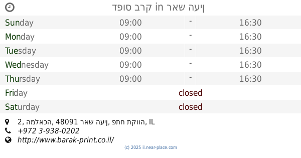
דפוס ברק
המלאכה 2, ראש העין
Store
read more
14.153 km
בית האינסטלציה בעמ
חמזה, כפר קאסם
Store
read more
14.282 km
מימדים חומרי שילוט
חמזה, כפר קאסם
Store
read more
14.755 km
גרעיני עפולה
כפר קאסם
Store
read more
15.07 km
3d Printing Center Israel
דרך הית 2, ראש העין
Store
read more
15.569 km
אופטיקה נובו
AlQuds Street 1, Qalansawe
Store
read more
15.592 km
ספורט לב הארץ
Yehuda Halevi Street 69, Rosh Haayin
Store
read more
15.741 km
אופטיקה 200
Tsahal Street 7, Rosh Haayin
Store
read more
15.935 km
Supermarket Tayah
Qalansawe
Store
read more
16.049 km
מור שלטים
Ha-Avoda Street 32, Rosh Haayin
Store
read more
16.219 km
כפר השעשועים
Ha-Yetsira Street 6, Rosh Haayin
Store
read more
16.443 km
Nirit Beauty
Sderot Shlomo HaMelech 12-30, Rosh Haayin
Store
read more
16.811 km
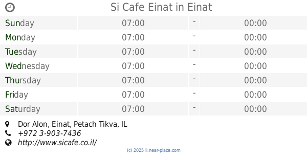
Si Cafe Einat
Dor Alon, Einat
Restaurant
Cafe
Food
Point of interest
Store
Establishment
read more
📑
all categories
Accounting
Administrative area level 1
Administrative area level 2
Airport
Amusement park
Aquarium
Art gallery
Atm
Bakery
Bank
Bar
Beauty salon
Bicycle store
Book store
Bowling alley
Bus station
Cafe
Campground
Car dealer
Car rental
Car repair
Car wash
Casino
Cemetery
Church
City hall
Clothing store
Colloquial area
Convenience store
Country
Courthouse
Dentist
Department store
Doctor
Electrician
Electronics store
Embassy
Establishment
Finance
Fire station
Florist
Food
Funeral home
Furniture store
Gas station
General contractor
Grocery or supermarket
Gym
Hair care
Hardware store
Health
Hindu Temple
Home goods store
Hospital
Insurance agency
Intersection
Jewelry store
Laundry
Lawyer
Library
Light rail station
Liquor store
Local government office
Locality
Locksmith
Lodging
Meal delivery
Meal takeaway
Mosque
Movie rental
Movie theater
Moving company
Museum
Natural feature
Neighborhood
Night club
Painter
Park
Parking
Pet store
Pharmacy
Physiotherapist
Place of worship
Plumber
Point of interest
Police
Political
Post office
Premise
Real estate agency
Restaurant
Roofing contractor
Route
Rv park, camping
School
Shoe store
Shopping mall
Spa
Stadium
Storage
Store
Subpremise
Subway station
Supermarket
Synagogue
Taxi stand
Train station
Transit station
Travel agency
University
Veterinary care
Zoo
administrative area level 3
administrative area level 4
sublocality level 1
↑