Store nearby לול טי וי
Israel
Store nearby לול טי וי
לול טי וי
גבעת השלושה, 4880000, ישראל
contacts phone
:
+972 3-656-5500
website:
www.looltv.com
Latitude:
32.0974022
, Longitude:
34.9216641
larger map & directions
read more
nearest Store
220 m
פפוש
Unnamed Road, Giv'at HaShlosha
Cafe
Food
Point of interest
Store
Establishment
read more
302 m
פשוש בית להורים וילדים
Givat HaShlosha
Store
read more
302 m
פשוש בית להורים וילדים
גבעת השלושה
Store
read more
1.5 km
תיק התיקים
פארק אפק, HaMelacha 4, Rosh Haayin
Store
read more
1.5 km
תיק התיקים
פארק אפק, המלאכה 4, ראש העין
Store
read more
1.743 km
Гейм Ворлд
Gluska Street 15, Rosh Haayin
Store
read more
1.797 km
אומנויות מכל הלב
HaAtsmaut Street 24, Rosh Haayin
Store
read more
1.797 km
אומנויות מכל הלב
העצמאות 24, ראש העין
Store
read more
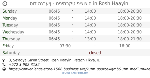
1.848 km
סוד הגרעין - מינימרקט פיצוציה
Se'adya Ga'on Street 3, Rosh Haayin
Grocery or supermarket
Supermarket
Food
Point of interest
Store
Establishment
read more
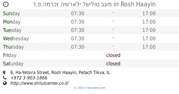
1.902 km
ד.פ.המרכז הישראלי לשילוט בעמ
Ha-Yetsira Street 6, Rosh Haayin
Store
read more
1.903 km
כפר השעשועים
Ha-Yetsira Street 6, Rosh Haayin
Store
read more
1.933 km
שולמן ציוד לימודי
Ha-Ta'asiya Street 4, Rosh Haayin
Store
read more
1.933 km
שולמן ציוד לימודי
התעשייה 4, ראש העין
Store
read more
1.942 km
פארם Fix
הרב שלום שבזי 15, ראש העין
Store
read more
2.078 km
שרות וציוד בעמ
העבודה 36, ראש העין
Store
read more
2.086 km
מור שלטים
Ha-Avoda Street 32, Rosh Haayin
Store
read more
2.272 km
פליקס גרינוורצל ובנו בע"מ
Israel National Trail, Einat
Store
read more
2.438 km
הגלריה של אסף
Einat
Store
read more
2.438 km
הגלריה של אסף
עינת
Store
read more
2.491 km
אוהד אופנועים
עינת
Store
read more
2.652 km
La Goffre
Elazar Fridman Street 9, Petah Tikva
Store
read more
2.659 km
קרביץ סירקין - קניון עופר
אלעזר פרידמן 9, פתח תקווה
Store
read more
2.668 km
Mix Max
Elazar Fridman Street 9, Petah Tikva
Store
read more
2.676 km
The Body Shop
Elazar Fridman Street 9, Petah Tikva
Store
read more
2.687 km
Mama Yokero
Elazar Fridman Street 9, Petah Tikva
Store
read more
📑
all categories
Accounting
Administrative area level 1
Administrative area level 2
Airport
Amusement park
Aquarium
Art gallery
Atm
Bakery
Bank
Bar
Beauty salon
Bicycle store
Book store
Bowling alley
Bus station
Cafe
Campground
Car dealer
Car rental
Car repair
Car wash
Casino
Cemetery
Church
City hall
Clothing store
Colloquial area
Convenience store
Country
Courthouse
Dentist
Department store
Doctor
Electrician
Electronics store
Embassy
Establishment
Finance
Fire station
Florist
Food
Funeral home
Furniture store
Gas station
General contractor
Grocery or supermarket
Gym
Hair care
Hardware store
Health
Hindu Temple
Home goods store
Hospital
Insurance agency
Intersection
Jewelry store
Laundry
Lawyer
Library
Light rail station
Liquor store
Local government office
Locality
Locksmith
Lodging
Meal delivery
Meal takeaway
Mosque
Movie rental
Movie theater
Moving company
Museum
Natural feature
Neighborhood
Night club
Painter
Park
Parking
Pet store
Pharmacy
Physiotherapist
Place of worship
Plumber
Point of interest
Police
Political
Post office
Premise
Real estate agency
Restaurant
Roofing contractor
Route
Rv park, camping
School
Shoe store
Shopping mall
Spa
Stadium
Storage
Store
Subpremise
Subway station
Supermarket
Synagogue
Taxi stand
Train station
Transit station
Travel agency
University
Veterinary care
Zoo
administrative area level 3
administrative area level 4
sublocality level 1
↑