Store nearby Itzik Levy dragged
Israel
Store nearby Itzik Levy dragged
Itzik Levy dragged
Джальджулия, Израиль
contacts phone
:
+972
Latitude:
32.1524568
, Longitude:
34.9539749
larger map & directions
read more
nearest Store
137 m
מזוודות הלאל شنط هلال
124 Street, Jaljulia
Store
read more
137 m
מזוודות הלאל شنط هلال
124, ג'לג'וליה
Store
read more
262 m
אטליז סאריס
31,, 127 Street 17, Jaljulia
Store
read more
290 m
דפוס עדן
1, רחוב ראשי, רחוב מספר 1 בית 20, Jaljulia
Store
read more
290 m
דפוס עדן
1, רחוב ראשי, רחוב מספר 1 בית 20, ג'לג'וליה
Store
read more
637 m
אטליז אלדייעה
ג'לג'וליה
Store
read more
637 m
Butcher Aldiiah
Jaljulia
Store
read more
1.213 km
נ.י. טנק ישראל בעמ - השכרה ותפעול מדיחים תעשייתיים
HaNarkis Street 84, Hagor
Store
read more
1.229 km
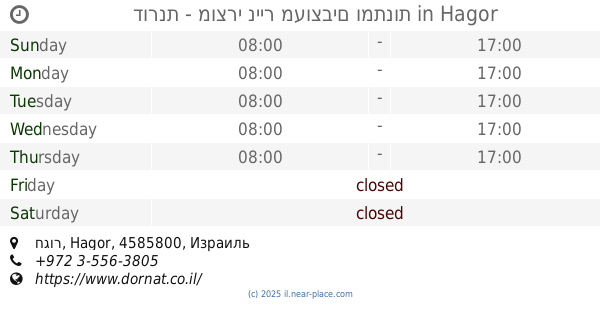
דורנת - מוצרי נייר מעוצבים ומתנות
חגור, Hagor
Store
read more
1.321 km
דלתות כניסה וריאציה
תד 104, Yarhiv
Store
read more
1.49 km
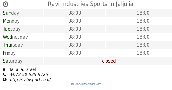
Ravi Industries Sports
Jaljulia
Store
read more
1.611 km
קואלה פתרונות מיחזור בעמ
Ekaliptus Street 1, Sdei Hemed
Store
read more
1.947 km
Peace Nursery
Israel
Store
read more
1.947 km
משתלת השלום
Israel
Store
read more
1.967 km
יינות ביתן - מתן
Hadar Street 84, Matan
Supermarket
Grocery or supermarket
Store
Food
Point of interest
Establishment
read more
1.998 km
אלגומה שופ
עתיר ידע 20, כפר סבא
Store
read more
2.011 km
עדן אריזות בע"מ
הנורית 25, חגור
Store
read more
2.096 km
עץ המחלף בעמ
Kafr Bara
Store
read more
2.162 km
מחיר סופי
אזור תעשייה
Store
read more
2.207 km
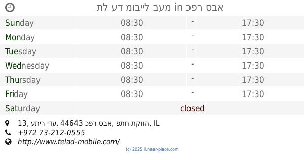
Tel to Mobile Ltd.
Atir Yeda Street 13, Kefar Sava
Store
read more
2.207 km
תל עד מובייל בעמ
עתיר ידע 13, כפר סבא
Store
read more
2.41 km
רמח חריטה ושילוט
HaArava Street 68, Neve Yamin
Store
read more
2.41 km
ביוטי אימיג'
HaArava Street 70, Neve Yamin
Store
read more
2.534 km
טופ אסקייפ רום
הרימון 82, נווה ימין
Store
read more
2.534 km
Top Escape Room
Harimon Street 82, Neve Yamin
Store
read more
📑
all categories
Accounting
Administrative area level 1
Administrative area level 2
Airport
Amusement park
Aquarium
Art gallery
Atm
Bakery
Bank
Bar
Beauty salon
Bicycle store
Book store
Bowling alley
Bus station
Cafe
Campground
Car dealer
Car rental
Car repair
Car wash
Casino
Cemetery
Church
City hall
Clothing store
Colloquial area
Convenience store
Country
Courthouse
Dentist
Department store
Doctor
Electrician
Electronics store
Embassy
Establishment
Finance
Fire station
Florist
Food
Funeral home
Furniture store
Gas station
General contractor
Grocery or supermarket
Gym
Hair care
Hardware store
Health
Hindu Temple
Home goods store
Hospital
Insurance agency
Intersection
Jewelry store
Laundry
Lawyer
Library
Light rail station
Liquor store
Local government office
Locality
Locksmith
Lodging
Meal delivery
Meal takeaway
Mosque
Movie rental
Movie theater
Moving company
Museum
Natural feature
Neighborhood
Night club
Painter
Park
Parking
Pet store
Pharmacy
Physiotherapist
Place of worship
Plumber
Point of interest
Police
Political
Post office
Premise
Real estate agency
Restaurant
Roofing contractor
Route
Rv park, camping
School
Shoe store
Shopping mall
Spa
Stadium
Storage
Store
Subpremise
Subway station
Supermarket
Synagogue
Taxi stand
Train station
Transit station
Travel agency
University
Veterinary care
Zoo
administrative area level 3
administrative area level 4
sublocality level 1
↑