Store nearby הממלכה
Israel
Store nearby הממלכה
הממלכה
10, חנקין, הוד השרון, פתח תקווה, IL ישראל
contacts phone
:
+972 9-894-6404
website:
thekingdom.co.il
Latitude:
32.1601153
, Longitude:
34.9043889
larger map & directions
read more
nearest Store
26 m
טופ גאדג'ט
חנקין 10, Hod Hasharon
Store
read more
81 m
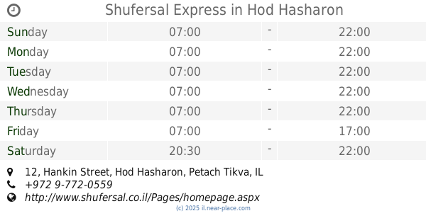
Shufersal Express
Hankin Street 12, Hod Hasharon
Supermarket
Grocery or supermarket
Food
Point of interest
Store
Establishment
read more
102 m
כפר השעשועים
חנקין 20, הוד השרון
Store
read more
164 m
אטליז יובל
סוקולוב 2, הוד השרון
Store
read more
182 m
טופ סלולר
סוקולוב 1, הוד השרון
Store
read more
189 m
Clean Skin
הרצל 6, הוד השרון
Store
read more
215 m
Top Cellular
ידידות 7, הוד השרון
Store
read more
215 m
טופ סלולר
ידידות 7, הוד השרון
Store
read more
295 m
סופר לאב
Derech Magdiel 57 Hod HaSharon IL 4534270, Derech Magdiel 57, Hod Hasharon
Store
read more
316 m
גבינות המשק
סוקולוב 7 הוד השרון IL
Store
read more
478 m
קארס דיל
Pduyim Street, Hod Hasharon
Store
read more
547 m
Seven Market
Asirey Tsiyon Street 22, Hod Hasharon
Supermarket
Grocery or supermarket
Food
Point of interest
Store
Establishment
read more
766 m
דפוס אווטלט
Ha-Khalutsim Street 4, Hod Hasharon
Store
read more
866 m
המשתלה של דני
אסירי ציון 41, הוד השרון
Store
read more
936 m
ARTnBED
Hod Hasharon
Store
read more
952 m
קוי טאטו | Koi-Tattoo
דרך מגדיאל 8, הוד השרון, ישראל, Hod Hasharon
Store
read more
958 m
Golda ice cream
Derech Magdiel 5, Hod Hasharon
Store
read more
965 m
נדל"ן בהוד השרון-ערן ישראלי
דרך רמתיים 38, הוד השרון
Store
read more
983 m
תחושת בטן הוד השרון
דרך רמתיים 57, הוד השרון
Store
read more
986 m
Vaniglia Hod Hasharon
18, Ramatayim Road, Hod Hasharon
Store
read more
1.017 km
מפצח האגוזים
דרך מגדיאל 1, הוד השרון
Store
read more
1.039 km
היפר זול
דרך רמתיים 78, הוד השרון
Store
read more
1.043 km
לינדה
דרך רמתיים 84, הוד השרון
Store
read more
1.046 km
שרזי מרדכי טכניקה
דרך רמתיים 80, הוד השרון
Store
read more
1.068 km
אריה פסח
Yehoshua Ben Gamla Street 7, Hod Hasharon
Store
read more
📑
all categories
Accounting
Administrative area level 1
Administrative area level 2
Airport
Amusement park
Aquarium
Art gallery
Atm
Bakery
Bank
Bar
Beauty salon
Bicycle store
Book store
Bowling alley
Bus station
Cafe
Campground
Car dealer
Car rental
Car repair
Car wash
Casino
Cemetery
Church
City hall
Clothing store
Colloquial area
Convenience store
Country
Courthouse
Dentist
Department store
Doctor
Electrician
Electronics store
Embassy
Establishment
Finance
Fire station
Florist
Food
Funeral home
Furniture store
Gas station
General contractor
Grocery or supermarket
Gym
Hair care
Hardware store
Health
Hindu Temple
Home goods store
Hospital
Insurance agency
Intersection
Jewelry store
Laundry
Lawyer
Library
Light rail station
Liquor store
Local government office
Locality
Locksmith
Lodging
Meal delivery
Meal takeaway
Mosque
Movie rental
Movie theater
Moving company
Museum
Natural feature
Neighborhood
Night club
Painter
Park
Parking
Pet store
Pharmacy
Physiotherapist
Place of worship
Plumber
Point of interest
Police
Political
Post office
Premise
Real estate agency
Restaurant
Roofing contractor
Route
Rv park, camping
School
Shoe store
Shopping mall
Spa
Stadium
Storage
Store
Subpremise
Subway station
Supermarket
Synagogue
Taxi stand
Train station
Transit station
Travel agency
University
Veterinary care
Zoo
administrative area level 3
administrative area level 4
sublocality level 1
↑