Store nearby המדיה
Israel
Store nearby המדיה
המדיה
Weizmann St 19 givataim IL 5339108, וייצמן 19, גבעתיים ישראל
contacts phone
:
+972
Latitude:
32.0743139
, Longitude:
34.8087744
read more
nearest Store
122 m
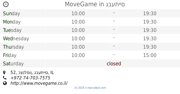
MoveGame
כצנלסון 52, גבעתיים
Store
read more
129 m
Hamalabiya Givvataim
Katzenelson Street 65, Giv'atayim
Store
read more
129 m
קוקינלסון
כצנלסון 52, גבעתיים
Store
read more
442 m
אטליז דאהן
הצנחנים 7, גבעתיים
Store
read more
591 m
Tech Factory Plus
כצנלסון 5, גבעתיים
Store
read more
603 m
משקפשים
כצנלסון 8, גבעתיים
Store
read more
651 m
עדי כרמי קוסמטיקאית רפואית
Reines 1 Giv'atayim IL 5646001, Reines Street 1, Giv'atayim
Store
read more
651 m
מרקט SHUK
ריינס 1, גבעתיים
Store
read more
717 m
Tom's cafe
Sirkin Street 16, Ramat Gan
Cafe
Food
Point of interest
Store
Establishment
read more
739 m
מעבדת סלולר
גבעתיים
Store
read more
766 m
סקס סיטי
Arlozorov Street 1, Ramat Gan
Store
read more
820 m
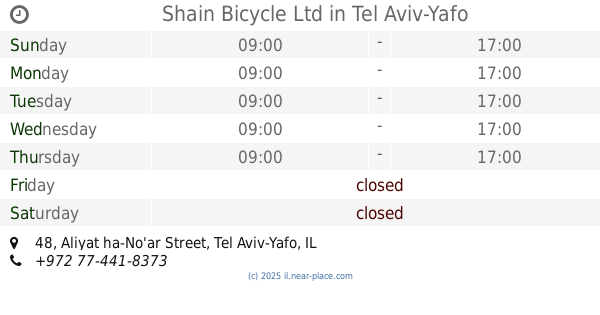
Shain Bicycle Ltd
Aliyat ha-No'ar Street 48, Tel Aviv-Yafo
Store
read more
832 m
הולה
עליית הנוער 50, גבעתיים
Store
read more
863 m
קישריה
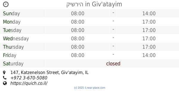
Katzenelson Street 147, Giv'atayim
Cafe
Restaurant
Food
Point of interest
Store
Establishment
read more
870 m
חנות עולם של כלבים
דב פרידמן 21, רמת גן
Store
read more
880 m
Shilav
Krinitsi Street 7, Ramat Gan
Store
read more
885 m
Sports Line
Bialik Street 15, Ramat Gan
Store
read more
885 m
Le Roy Rebe
Derech Yitshak Rabin 53, Giv'atayim
Store
read more
890 m
Pets
ביאליק 18, רמת גן
Store
read more
909 m
רמי לוי בשכונה
David Ben Gurion Road 182, Giv'atayim
Supermarket
Grocery or supermarket
Food
Point of interest
Store
Establishment
read more
935 m
ארנקי ארפל
ביאליק 21, רמת גן
Store
read more
1.058 km
More fruits and vegetables
Derech Yitshak Rabin 28, Giv'atayim
Store
read more
1.081 km
קפה יאיא
Krinitsi Street 32, Ramat Gan
Cafe
Food
Point of interest
Store
Establishment
read more
1.088 km
Склад Бецалель
HaMa'ayan Street 10, Ramat Gan
Store
read more
1.192 km
Lato Sensu Ltd
רח' זאב ז'בוטינסקי 3, רמת גן
Store
read more
📑
all categories
Accounting
Administrative area level 1
Administrative area level 2
Airport
Amusement park
Aquarium
Art gallery
Atm
Bakery
Bank
Bar
Beauty salon
Bicycle store
Book store
Bowling alley
Bus station
Cafe
Campground
Car dealer
Car rental
Car repair
Car wash
Casino
Cemetery
Church
City hall
Clothing store
Colloquial area
Convenience store
Country
Courthouse
Dentist
Department store
Doctor
Electrician
Electronics store
Embassy
Establishment
Finance
Fire station
Florist
Food
Funeral home
Furniture store
Gas station
General contractor
Grocery or supermarket
Gym
Hair care
Hardware store
Health
Hindu Temple
Home goods store
Hospital
Insurance agency
Intersection
Jewelry store
Laundry
Lawyer
Library
Light rail station
Liquor store
Local government office
Locality
Locksmith
Lodging
Meal delivery
Meal takeaway
Mosque
Movie rental
Movie theater
Moving company
Museum
Natural feature
Neighborhood
Night club
Painter
Park
Parking
Pet store
Pharmacy
Physiotherapist
Place of worship
Plumber
Point of interest
Police
Political
Post office
Premise
Real estate agency
Restaurant
Roofing contractor
Route
Rv park, camping
School
Shoe store
Shopping mall
Spa
Stadium
Storage
Store
Subpremise
Subway station
Supermarket
Synagogue
Taxi stand
Train station
Transit station
Travel agency
University
Veterinary care
Zoo
administrative area level 3
administrative area level 4
sublocality level 1
↑