Store nearby Dr food
Israel
Store nearby Dr food
Dr food
33, Ein Hai Street, Kfar Malal, Petach Tikva, IL Israel
contacts phone
:
+972 9-744-4665
website:
www.drfood.co.il
Latitude:
32.1683344
, Longitude:
34.8936001
larger map & directions
read more
nearest Store
75 m
עוצמה דודי שמש ומערכות סולאריות
Ein Hai Street 33, Kfar Malal
Store
read more
76 m
מודי - MODY כפר מל"ל
Ein Hai Street 33, Kfar Malal
Store
read more
192 m
פסטה דלה קזה - כפר מלל
עין חי 43, כפר מל"ל
Store
read more
399 m
La Brocant לה ברוקנט
HaLimon Street 19, Ramot HaShavim
Store
read more
587 m
Keshet Teamim
Netiv HaAvot 14, Kfar Saba
Supermarket
Grocery or supermarket
Food
Point of interest
Store
Establishment
read more
731 m
הדים כפר סבא
Netiv HaAvot 3, Kefar Sava
Store
read more
731 m
הדים כפר סבא
נתיב האבות 3, כפר סבא
Store
read more
842 m
פרי וירק כפר סבא
Ha-Kalanit Street 2, Kefar Sava
Store
read more
842 m
דפוס אווטלט
Ha-Khalutsim Street 4, Hod Hasharon
Store
read more
847 m
Vaniglia Hod Hasharon
18, Ramatayim Road, Hod Hasharon
Store
read more
852 m
Vaniligia
הוד השרון
Store
read more
878 m
פירות וירקות שלומי
גורדון 18, כפר סבא
Store
read more
925 m
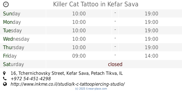
Killer Cat Tattoo
Tchernichovsky Street 16, Kefar Sava
Store
read more
1.062 km
גבינות המשק
סוקולוב 7 הוד השרון IL
Store
read more
1.111 km
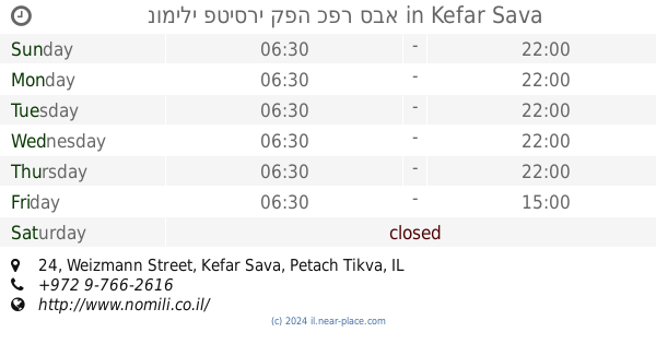
נומילי פטיסרי קפה כפר סבא
Weizmann Street 24, Kefar Sava
Bakery
Cafe
Food
Point of interest
Store
Establishment
read more
1.161 km
Deli Cream
Weizmann Street 40, Kefar Sava
Store
read more
1.161 km
דלי קרים
ויצמן 40, כפר סבא
Store
read more
1.167 km
Top Cellular
ידידות 7, הוד השרון
Store
read more
1.167 km
טופ סלולר
ידידות 7, הוד השרון
Store
read more
1.173 km
לה בורסה כפר סבא
ויצמן 42, כפר סבא
Store
read more
1.192 km
טופ סלולר
סוקולוב 1, הוד השרון
Store
read more
1.203 km
אטליז יובל
סוקולוב 2, הוד השרון
Store
read more
1.261 km
ממלכת קלייה וטבע
Derech Magdiel 54, Hod Hasharon
Store
read more
1.322 km
ללין
ברל כצנלסון 14, כפר סבא
Store
read more
1.365 km
Elidan Computers
Berl Katsnelson Street 14, Kefar Sava
Store
read more
📑
all categories
Accounting
Administrative area level 1
Administrative area level 2
Airport
Amusement park
Aquarium
Art gallery
Atm
Bakery
Bank
Bar
Beauty salon
Bicycle store
Book store
Bowling alley
Bus station
Cafe
Campground
Car dealer
Car rental
Car repair
Car wash
Casino
Cemetery
Church
City hall
Clothing store
Colloquial area
Convenience store
Country
Courthouse
Dentist
Department store
Doctor
Electrician
Electronics store
Embassy
Establishment
Finance
Fire station
Florist
Food
Funeral home
Furniture store
Gas station
General contractor
Grocery or supermarket
Gym
Hair care
Hardware store
Health
Hindu Temple
Home goods store
Hospital
Insurance agency
Intersection
Jewelry store
Laundry
Lawyer
Library
Light rail station
Liquor store
Local government office
Locality
Locksmith
Lodging
Meal delivery
Meal takeaway
Mosque
Movie rental
Movie theater
Moving company
Museum
Natural feature
Neighborhood
Night club
Painter
Park
Parking
Pet store
Pharmacy
Physiotherapist
Place of worship
Plumber
Point of interest
Police
Political
Post office
Premise
Real estate agency
Restaurant
Roofing contractor
Route
Rv park, camping
School
Shoe store
Shopping mall
Spa
Stadium
Storage
Store
Subpremise
Subway station
Supermarket
Synagogue
Taxi stand
Train station
Transit station
Travel agency
University
Veterinary care
Zoo
administrative area level 3
administrative area level 4
sublocality level 1
↑