Store nearby Barmor
Israel
Store nearby Barmor
Barmor
קדימה צורן, ישראל
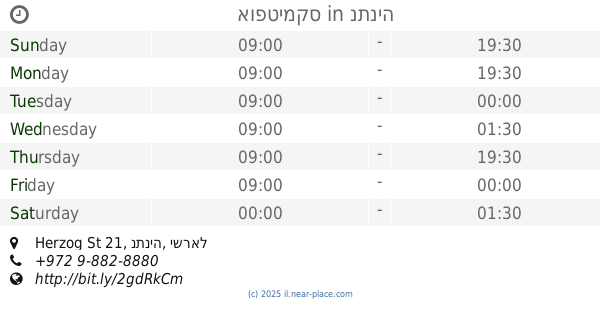
contacts phone
:
+972
Latitude:
32.2685169
, Longitude:
34.8955604
larger map & directions
read more
nearest Store
474 m
לנדוור מובייל landver mobile
קניון אבן יהודה, המייסדים 41, אבן יהודה
Store
read more
490 m
מיכל גרין אופטיקה
Ha-Meyasdim Street 41, Even Yehuda
Store
read more
542 m
Mimimomomamma אלבומים מעוצבים
סמטת עופרית 7, אבן יהודה
Store
read more
592 m
טיקום TIKCOM
אבן יהודה, Bnei Binyamin Street 3
Store
read more
905 m
Kiki funny Akiva photographer
Bnei Binyamin Street 24, Even Yehuda
Store
read more
910 m
פיטר הומל''ס
מרכז מסחרי, בני דרור
Store
read more
911 m
אופטיקה קמינסקי
קניון דרורים, צומת בני דרור
Store
read more
923 m
וניליה דרורים
קניון דרורים
Store
read more
923 m
Vanilia Drorim
קניון דרורים
Store
read more
932 m
Kravitz
קניון דרורים, בני דרור
Store
read more
932 m
Кравиц
קניון דרורים, בני דרור
Store
read more
932 m
קרביץ דרורים
קניון דרורים, בני דרור
Store
read more
950 m
פירות בני דרור בעמ
בני דרור
Store
read more
950 m
Fruit Bnei Dror Ltd.
Bnei Dror
Store
read more
955 m
קמינסקי אופטיקה
קניון דרורים, Bnei Dror
Store
read more
1.026 km
Toy Store טוי-סטור
העצמאות 56, אבן יהודה
Store
read more
1.026 km
Toy Store טוי-סטור
HaAtsmaut Street 56, Even Yehuda
Store
read more
1.274 km
פלד אינסטלציה
מעלה הארגמן 23, אבן יהודה
Store
read more
1.274 km
פלד אינסטלציה
Ma'ale ha-Argaman Street 23, Even Yehuda
Store
read more
1.373 km
העץ הרצליה
שיזף 3, אבן יהודה
Store
read more
1.461 km
סופח לחות
רימון 2 אבן יהודה
Store
read more
1.635 km
משתלת קדימה
צומת הדסים, קדימה צורן
Store
read more
1.975 km
י.ד. עידה בעמ
עידה ממתקים אבן יהודה ב- Waze א.ת אבן יהודה , כיכר התעשיות, אבן יהודה
Store
read more
2.096 km
רודי פרוגקט- מרכז שרות יבואן Rudy Project Israel
Ha-Shalom Street 8, Kfar Netter
Store
read more
2.287 km
אופטימקס
Herzog St 21, נתניה
Store
read more
📑
all categories
Accounting
Administrative area level 1
Administrative area level 2
Airport
Amusement park
Aquarium
Art gallery
Atm
Bakery
Bank
Bar
Beauty salon
Bicycle store
Book store
Bowling alley
Bus station
Cafe
Campground
Car dealer
Car rental
Car repair
Car wash
Casino
Cemetery
Church
City hall
Clothing store
Colloquial area
Convenience store
Country
Courthouse
Dentist
Department store
Doctor
Electrician
Electronics store
Embassy
Establishment
Finance
Fire station
Florist
Food
Funeral home
Furniture store
Gas station
General contractor
Grocery or supermarket
Gym
Hair care
Hardware store
Health
Hindu Temple
Home goods store
Hospital
Insurance agency
Intersection
Jewelry store
Laundry
Lawyer
Library
Light rail station
Liquor store
Local government office
Locality
Locksmith
Lodging
Meal delivery
Meal takeaway
Mosque
Movie rental
Movie theater
Moving company
Museum
Natural feature
Neighborhood
Night club
Painter
Park
Parking
Pet store
Pharmacy
Physiotherapist
Place of worship
Plumber
Point of interest
Police
Political
Post office
Premise
Real estate agency
Restaurant
Roofing contractor
Route
Rv park, camping
School
Shoe store
Shopping mall
Spa
Stadium
Storage
Store
Subpremise
Subway station
Supermarket
Synagogue
Taxi stand
Train station
Transit station
Travel agency
University
Veterinary care
Zoo
administrative area level 3
administrative area level 4
sublocality level 1
↑