Shopping mall nearby My Old Market
Israel
Shopping mall nearby My Old Market
My Old Market
Szfar'am, Izrael
contacts phone
:
+972
Latitude:
32.8052218
, Longitude:
35.1699276
larger map & directions
read more
nearest Shopping mall
שוק עירוני ישן
שפרעם
Shopping mall
read more
360 m
Ak Kaloti Center مركز الكالوتي لكل جميل
440, שפרעם
Shopping mall
read more
1.743 km
קניון שפרעם
שפרעם
Shopping mall
read more
2.061 km
Samara Brothers Shopping Center
Shefa-'Amr
Shopping mall
read more
2.061 km
מרכז מסחרי אחים סמארה
שפרעם
Shopping mall
read more
2.1 km
קניון שפרעם
אזור תעשיה מזרחי, שפרעם
Shopping mall
read more
2.168 km
Grocery Store
עדי
Shopping mall
read more
2.168 km
Grocery Store
Adi
Shopping mall
read more
4.611 km
Grocery Store
Ramat Yohanan
Shopping mall
read more
8.44 km
Kiryon Mall Building B
קריית ביאליק
Shopping mall
read more
8.889 km
שוק עירוני
קריית ביאליק
Shopping mall
read more
10.478 km
מרכז ניצן
קרית ים
Shopping mall
read more
10.583 km
Factory 54 MALL
החרושת 10, חיפה
Shopping mall
read more
10.843 km
סטריט מול
אקליפטוס 3, רמת ישי
Shopping mall
read more
10.87 km
Vertex מזרנים
Ha-Kharoshet 10,pob 12068,, Haifa
Shopping mall
read more
11.226 km
דני מרקט
Sde Boker Street 9, Qiryat haim
Shopping mall
read more
12.11 km
Commercial Center Mall Misgav
Israel
Shopping mall
read more
12.845 km
Керамика
HaNapah Street 16-20, Haifa
Shopping mall
read more
14.676 km
Ziv Center
Хайфа
Shopping mall
read more
17.167 km
عمر المختار
4059 Street 27, Nazareth
Shopping mall
read more
18.247 km
Hani Center
Нацрат-Иллит
Shopping mall
read more
18.254 km
Hani Center
Ha-Lulav Street 25, Nazareth Iliit
Shopping mall
read more
19.75 km
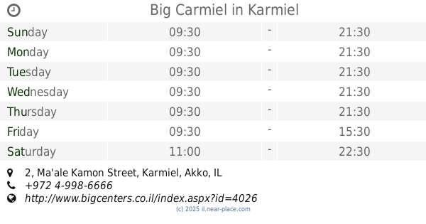
Big Carmiel
Ma'ale Kamon Street 2, Karmiel
Shopping mall
read more
20.004 km
קרולינה למקה כרמיאל
כרמיאל
Shopping mall
read more
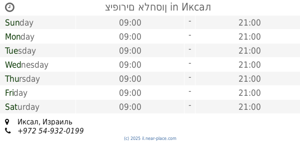
20.261 km
ציפורים אלחסון
Iksal
Shopping mall
read more
📑
all categories
Accounting
Administrative area level 1
Administrative area level 2
Airport
Amusement park
Aquarium
Art gallery
Atm
Bakery
Bank
Bar
Beauty salon
Bicycle store
Book store
Bowling alley
Bus station
Cafe
Campground
Car dealer
Car rental
Car repair
Car wash
Casino
Cemetery
Church
City hall
Clothing store
Colloquial area
Convenience store
Country
Courthouse
Dentist
Department store
Doctor
Electrician
Electronics store
Embassy
Establishment
Finance
Fire station
Florist
Food
Funeral home
Furniture store
Gas station
General contractor
Grocery or supermarket
Gym
Hair care
Hardware store
Health
Hindu Temple
Home goods store
Hospital
Insurance agency
Intersection
Jewelry store
Laundry
Lawyer
Library
Light rail station
Liquor store
Local government office
Locality
Locksmith
Lodging
Meal delivery
Meal takeaway
Mosque
Movie rental
Movie theater
Moving company
Museum
Natural feature
Neighborhood
Night club
Painter
Park
Parking
Pet store
Pharmacy
Physiotherapist
Place of worship
Plumber
Point of interest
Police
Political
Post office
Premise
Real estate agency
Restaurant
Roofing contractor
Route
Rv park, camping
School
Shoe store
Shopping mall
Spa
Stadium
Storage
Store
Subpremise
Subway station
Supermarket
Synagogue
Taxi stand
Train station
Transit station
Travel agency
University
Veterinary care
Zoo
administrative area level 3
administrative area level 4
sublocality level 1
↑