Shopping mall nearby מרכז מסחרי סקי גלבוע
Coronavirus disease (COVID-19) Situation
confirmed cases
4841772
deaths
12707
Israel
Shopping mall nearby מרכז מסחרי סקי גלבוע
מרכז מסחרי סקי גלבוע
Израиль
contacts phone
:
+972
Latitude:
32.5527445
, Longitude:
35.3338227
larger map & directions
read more
nearest Shopping mall
2.696 km
Grocery Store
אביטל
Shopping mall
read more
2.795 km
Grocery Store
גן נר
Shopping mall
read more
2.795 km
Grocery Store
Gan Ner
Shopping mall
read more
3.059 km
Grocery Store
Kfar Yehezkel
Shopping mall
read more
3.151 km
Grocery Store
מיטב
Shopping mall
read more
6.896 km
Afula structure
Kehilat Tsiyon Street 20-24, Afula
Shopping mall
read more
6.977 km
Big Afula
HaShuk Street 13, Afula
Shopping mall
read more
7.669 km
Friendly
Yitshak Rabin Boulevard 18, Afula
Shopping mall
read more
7.681 km
מרכז G בעמק
שדרות יצחק רבין 18, עפולה
Shopping mall
read more
8.621 km
Grocery Store
Merkaz Omen
Shopping mall
read more
9.041 km
מתחם פז סנטר תענכים
כביש 675, ניר יפה
Shopping mall
read more
9.689 km
Tastes of curtains, carpets, mattresses, household
Gamal Abdel Nasser Street, Al Bayda
Shopping mall
read more
9.701 km
Albulhh Shoes Showroom
Jemmal
Shopping mall
read more
9.834 km
Kolbo Alonit
Beit HaShita
Shopping mall
read more
10.797 km
Grocery Store
Moledet
Shopping mall
read more
11.169 km
מכולת
טמרה
Shopping mall
read more
11.736 km
מכולת
Taibe
Shopping mall
read more
14.178 km
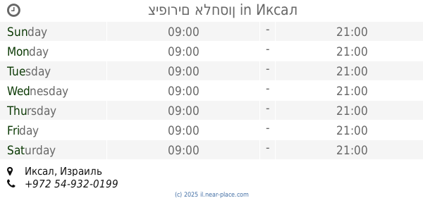
ציפורים אלחסון
Iksal
Shopping mall
read more
16.27 km
קניון לב העמק
מגדל העמק
Shopping mall
read more
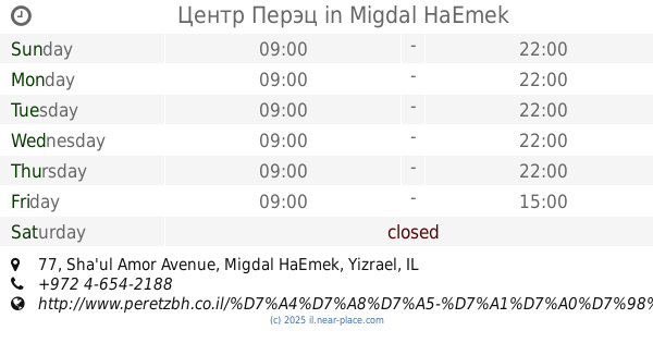
16.295 km
Центр Перэц
Sha'ul Amor Avenue 77, Migdal HaEmek
Shopping mall
read more
17.011 km
Aosnt Robin
Nitsanim Street 39, Migdal HaEmek
Shopping mall
read more
17.22 km
ميني ماركت الخطيب
Covert
Shopping mall
read more
17.221 km
קניונית יפעת
יפעת
Shopping mall
read more
18.353 km
Grocery Store
רחוב
Shopping mall
read more
18.353 km
Grocery Store
Rehov
Shopping mall
read more
📑
all categories
Accounting
Administrative area level 1
Administrative area level 2
Airport
Amusement park
Aquarium
Art gallery
Atm
Bakery
Bank
Bar
Beauty salon
Bicycle store
Book store
Bowling alley
Bus station
Cafe
Campground
Car dealer
Car rental
Car repair
Car wash
Casino
Cemetery
Church
City hall
Clothing store
Colloquial area
Convenience store
Country
Courthouse
Dentist
Department store
Doctor
Electrician
Electronics store
Embassy
Establishment
Finance
Fire station
Florist
Food
Funeral home
Furniture store
Gas station
General contractor
Grocery or supermarket
Gym
Hair care
Hardware store
Health
Hindu Temple
Home goods store
Hospital
Insurance agency
Intersection
Jewelry store
Laundry
Lawyer
Library
Light rail station
Liquor store
Local government office
Locality
Locksmith
Lodging
Meal delivery
Meal takeaway
Mosque
Movie rental
Movie theater
Moving company
Museum
Natural feature
Neighborhood
Night club
Painter
Park
Parking
Pet store
Pharmacy
Physiotherapist
Place of worship
Plumber
Point of interest
Police
Political
Post office
Premise
Real estate agency
Restaurant
Roofing contractor
Route
Rv park, camping
School
Shoe store
Shopping mall
Spa
Stadium
Storage
Store
Subpremise
Subway station
Supermarket
Synagogue
Taxi stand
Train station
Transit station
Travel agency
University
Veterinary care
Zoo
administrative area level 3
administrative area level 4
sublocality level 1
↑