Shopping mall nearby Grocery Store
Israel
Shopping mall nearby Grocery Store
Grocery Store
אילון, ישראל
contacts phone
:
+972
Latitude:
33.0636353
, Longitude:
35.2210234
larger map & directions
read more
nearest Shopping mall
1.489 km
Grocery Store
גורן
Shopping mall
read more
6.146 km
Assi Center Mall
Mi'ilya
Shopping mall
read more
6.227 km
Grocery Store
Ein Ya'akov
Shopping mall
read more
7.031 km
מרכז מסחרי סיטי סנטר
מעלות תרשיחא
Shopping mall
read more
7.403 km
Home Center
Ma'alot-Tarshiha
Shopping mall
read more
7.845 km
Grocery Store
בצת
Shopping mall
read more
12.502 km
קניון שופינג סנטר
ירכא
Shopping mall
read more
12.64 km
GAIA Center
ירכא
Shopping mall
read more
12.645 km
כיכר קדמאני
Asa Kadmoni Street, Tel Aviv-Yafo
Shopping mall
read more
12.648 km
מרכז מסחרי שלמה
נהריה
Shopping mall
read more
12.648 km
Shlomo Shopping Center
Nahariyya
Shopping mall
read more
12.858 km
בית בד אבו עפיף
Hurfeish
Shopping mall
read more
12.896 km
Dahar Shopping Center
Yarka
Shopping mall
read more
13.122 km
שוק עירוני
כפר יאסיף
Shopping mall
read more
13.247 km
הוד הגעתון נהריה
Nahariyya
Shopping mall
read more
13.35 km
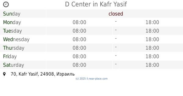
D Center
70, Kafr Yasif
Shopping mall
read more
13.367 km
קניון פרץ
Sderot HaGa'aton 28, Nahariyya
Shopping mall
read more
13.398 km
רוקמות התחרה חורפיש
route 89 horfeish
Shopping mall
read more
14.171 km
מתחם פז סנטר נהריה
כביש 4, נהריה
Shopping mall
read more
14.39 km
Hamed Center
Mazra'a
Shopping mall
read more
15.253 km
Pioneer mountain cliff
Israel
Shopping mall
read more
17.133 km
כלבו
Shomrat
Shopping mall
read more
18.514 km
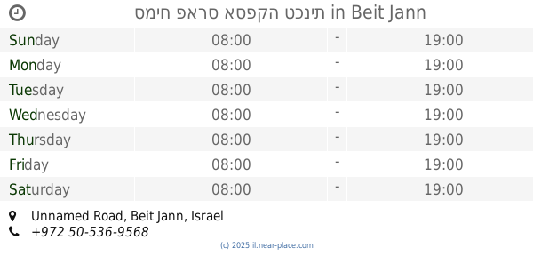
סמיח פארס אספקה טכנית
Unnamed Road, Beit Jann
Shopping mall
read more
18.923 km
Grocery Store
שזור
Shopping mall
read more
19.712 km
נעלי וליאם איוב - נעלי המשפחה
ראמה
Shopping mall
read more
📑
all categories
Accounting
Administrative area level 1
Administrative area level 2
Airport
Amusement park
Aquarium
Art gallery
Atm
Bakery
Bank
Bar
Beauty salon
Bicycle store
Book store
Bowling alley
Bus station
Cafe
Campground
Car dealer
Car rental
Car repair
Car wash
Casino
Cemetery
Church
City hall
Clothing store
Colloquial area
Convenience store
Country
Courthouse
Dentist
Department store
Doctor
Electrician
Electronics store
Embassy
Establishment
Finance
Fire station
Florist
Food
Funeral home
Furniture store
Gas station
General contractor
Grocery or supermarket
Gym
Hair care
Hardware store
Health
Hindu Temple
Home goods store
Hospital
Insurance agency
Intersection
Jewelry store
Laundry
Lawyer
Library
Light rail station
Liquor store
Local government office
Locality
Locksmith
Lodging
Meal delivery
Meal takeaway
Mosque
Movie rental
Movie theater
Moving company
Museum
Natural feature
Neighborhood
Night club
Painter
Park
Parking
Pet store
Pharmacy
Physiotherapist
Place of worship
Plumber
Point of interest
Police
Political
Post office
Premise
Real estate agency
Restaurant
Roofing contractor
Route
Rv park, camping
School
Shoe store
Shopping mall
Spa
Stadium
Storage
Store
Subpremise
Subway station
Supermarket
Synagogue
Taxi stand
Train station
Transit station
Travel agency
University
Veterinary care
Zoo
administrative area level 3
administrative area level 4
sublocality level 1
↑