Shopping mall nearby Grocery Store
Israel
Shopping mall nearby Grocery Store
Grocery Store
Shibli, Israel
contacts phone
:
+972
Latitude:
32.6772476
, Longitude:
35.3919986
larger map & directions
read more
nearest Shopping mall
1.781 km
Commercial Center Dvourah Center
Daburiyya
Shopping mall
read more
2.951 km
ملحمة الهلال سفيان يوسف
Daburiyya
Shopping mall
read more
2.951 km
ملحمة الهلال سفيان يوسف
דבוריה
Shopping mall
read more
3.152 km
מתחם מול התבור
כפר תבור
Shopping mall
read more
3.152 km
מתחם מול התבור
Kfar Tavor
Shopping mall
read more
3.164 km
מתחם מול תבור - כפר תבור
Bazelet Street 2, Kfar Tavor
Shopping mall
Supermarket
Shoe store
Grocery or supermarket
Clothing store
Store
Restaurant
Point of interest
Food
Establishment
read more
4.823 km
מכולת
טמרה
Shopping mall
read more
4.825 km
Grocery Store
Shadmot Dvora
Shopping mall
read more
6.043 km
ציפורים אלחסון
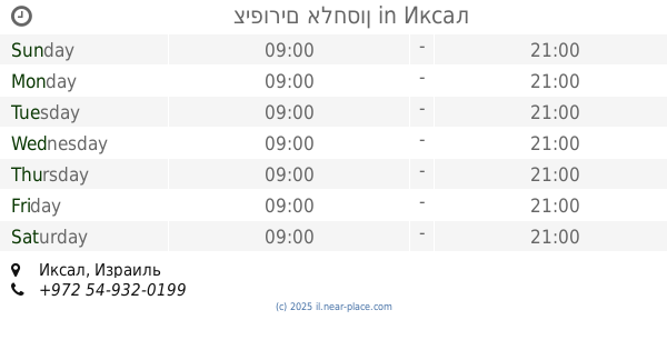
Iksal
Shopping mall
read more
6.832 km
הום סנטר
נצרת עילית
Shopping mall
read more
6.874 km
Saf Center mall
Nazareth Iliit
Shopping mall
read more
7.185 km
Hani Center
Ha-Lulav Street 25, Nazareth Iliit
Shopping mall
read more
7.193 km
Hani Center
Нацрат-Иллит
Shopping mall
read more
7.84 km
בריכה עירונית
נצרת עילית
Shopping mall
read more
8.638 km
عمر المختار
4059 Street 27, Nazareth
Shopping mall
read more
9.452 km
מכולת
Taibe
Shopping mall
read more
11.191 km
Grocery Store
Moledet
Shopping mall
read more
11.858 km
Afula structure
Kehilat Tsiyon Street 20-24, Afula
Shopping mall
read more
12.177 km
Big Afula
HaShuk Street 13, Afula
Shopping mall
read more
14.215 km
קניון לב העמק
מגדל העמק
Shopping mall
read more
14.861 km
Kolbo Alonit
Beit HaShita
Shopping mall
read more
17.364 km
מתחם פז סנטר תענכים
כביש 675, ניר יפה
Shopping mall
read more
18.203 km
מרכז מסחרי בזלת
טבריה
Shopping mall
read more
18.341 km
מרכז מסחרי גליל סנטר
Tiberias
Shopping mall
read more
Grocery Store
שיבלי
Shopping mall
read more
📑
all categories
Accounting
Administrative area level 1
Administrative area level 2
Airport
Amusement park
Aquarium
Art gallery
Atm
Bakery
Bank
Bar
Beauty salon
Bicycle store
Book store
Bowling alley
Bus station
Cafe
Campground
Car dealer
Car rental
Car repair
Car wash
Casino
Cemetery
Church
City hall
Clothing store
Colloquial area
Convenience store
Country
Courthouse
Dentist
Department store
Doctor
Electrician
Electronics store
Embassy
Establishment
Finance
Fire station
Florist
Food
Funeral home
Furniture store
Gas station
General contractor
Grocery or supermarket
Gym
Hair care
Hardware store
Health
Hindu Temple
Home goods store
Hospital
Insurance agency
Intersection
Jewelry store
Laundry
Lawyer
Library
Light rail station
Liquor store
Local government office
Locality
Locksmith
Lodging
Meal delivery
Meal takeaway
Mosque
Movie rental
Movie theater
Moving company
Museum
Natural feature
Neighborhood
Night club
Painter
Park
Parking
Pet store
Pharmacy
Physiotherapist
Place of worship
Plumber
Point of interest
Police
Political
Post office
Premise
Real estate agency
Restaurant
Roofing contractor
Route
Rv park, camping
School
Shoe store
Shopping mall
Spa
Stadium
Storage
Store
Subpremise
Subway station
Supermarket
Synagogue
Taxi stand
Train station
Transit station
Travel agency
University
Veterinary care
Zoo
administrative area level 3
administrative area level 4
sublocality level 1
↑