Shopping mall nearby المركز التجاري كفر مندا
Israel
Shopping mall nearby المركز التجاري كفر مندا
المركز التجاري كفر مندا
כפר מנדא, ישראל
contacts phone
:
+972
Latitude:
32.8060589
, Longitude:
35.2560094
larger map & directions
read more
nearest Shopping mall
المركز التجاري كفر مندا
Kafr Manda
Shopping mall
read more
276 m
Baby Mall
כפר מנדא
Shopping mall
read more
276 m
Baby Mall
Kafr Manda
Shopping mall
read more
651 m
سوبر ماركت النسيم
Kafr Manda
Shopping mall
read more
651 m
سوبر ماركت النسيم
כפר מנדא
Shopping mall
read more
2.651 km
Grocery Store
Hanaton
Shopping mall
read more
2.651 km
Grocery Store
חנתון
Shopping mall
read more
7.112 km
Commercial Center Mall Misgav
Israel
Shopping mall
read more
8.346 km
Ak Kaloti Center مركز الكالوتي لكل جميل
440, שפרעם
Shopping mall
read more
8.557 km
Grocery Store
Ka'abiyye-Tabbash-Hajajre
Shopping mall
read more
9.554 km
מרכז מסחרי בני שריף
עראבה
Shopping mall
read more
12.367 km
Grocery Store
מנשיית א זבדה
Shopping mall
read more
12.379 km
Saf Center mall
Nazareth Iliit
Shopping mall
read more
12.415 km
הום סנטר
נצרת עילית
Shopping mall
read more
12.677 km
عمر المختار
4059 Street 27, Nazareth
Shopping mall
read more
13.029 km
בריכה עירונית
נצרת עילית
Shopping mall
read more
13.173 km
Hani Center
Нацрат-Иллит
Shopping mall
read more
13.177 km
Hani Center
Ha-Lulav Street 25, Nazareth Iliit
Shopping mall
read more
13.355 km
קניון מול היער
Kiryat Tiv'on
Shopping mall
read more
13.37 km
סטריט מול
אקליפטוס 3, רמת ישי
Shopping mall
read more
13.573 km
קניון כיכר העיר
כרמיאל
Shopping mall
read more
14.885 km
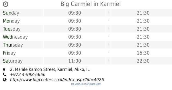
Big Carmiel
Ma'ale Kamon Street 2, Karmiel
Shopping mall
read more
15.095 km
קרולינה למקה כרמיאל
כרמיאל
Shopping mall
read more
15.513 km
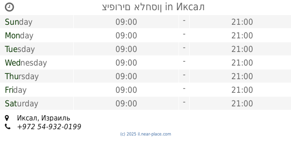
ציפורים אלחסון
Iksal
Shopping mall
read more
15.686 km
שוק עירוני
קריית ביאליק
Shopping mall
read more
📑
all categories
Accounting
Administrative area level 1
Administrative area level 2
Airport
Amusement park
Aquarium
Art gallery
Atm
Bakery
Bank
Bar
Beauty salon
Bicycle store
Book store
Bowling alley
Bus station
Cafe
Campground
Car dealer
Car rental
Car repair
Car wash
Casino
Cemetery
Church
City hall
Clothing store
Colloquial area
Convenience store
Country
Courthouse
Dentist
Department store
Doctor
Electrician
Electronics store
Embassy
Establishment
Finance
Fire station
Florist
Food
Funeral home
Furniture store
Gas station
General contractor
Grocery or supermarket
Gym
Hair care
Hardware store
Health
Hindu Temple
Home goods store
Hospital
Insurance agency
Intersection
Jewelry store
Laundry
Lawyer
Library
Light rail station
Liquor store
Local government office
Locality
Locksmith
Lodging
Meal delivery
Meal takeaway
Mosque
Movie rental
Movie theater
Moving company
Museum
Natural feature
Neighborhood
Night club
Painter
Park
Parking
Pet store
Pharmacy
Physiotherapist
Place of worship
Plumber
Point of interest
Police
Political
Post office
Premise
Real estate agency
Restaurant
Roofing contractor
Route
Rv park, camping
School
Shoe store
Shopping mall
Spa
Stadium
Storage
Store
Subpremise
Subway station
Supermarket
Synagogue
Taxi stand
Train station
Transit station
Travel agency
University
Veterinary care
Zoo
administrative area level 3
administrative area level 4
sublocality level 1
↑