Shoe store nearby Fly Foot
Israel
Shoe store nearby Fly Foot
Fly Foot
1, Derech HaRakevet, Ashdod, Ashkelon, IL Israel
contacts phone
:
+972 8-921-3030
website:
flyfoot.co.il
Latitude:
31.7758652
, Longitude:
34.6643037
larger map & directions
read more
nearest Shoe store
Fly Foot
דרך הרכבת 1, אשדוד
Shoe store
read more
17 m
Nike Store
1 Derech Harakevet, Big Fashion Center, Ashdod
Shoe store
read more
23 m
TO GO
Derech HaRakevet 1, Ashdod
Shoe store
read more
37 m
טבע נאות
Ashdod
Shoe store
read more
41 m
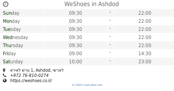
WeShoes
אריאל שרון 1, Ashdod
Shoe store
read more
49 m
Steve Madden
Derech HaRakevet 1, Ashdod
Shoe store
read more
63 m
אלדו - ALDO
Derech HaRakevet 1, ביג אשדוד, Ashdod
Shoe store
read more
63 m
ליידי קומפורט אשדוד -ביג פאשן
1, Derech HaRakevet, Ashdod
Shoe store
read more
63 m
Lady Comfort
דרך הרכבת 1, אשדוד
Shoe store
read more
75 m
שופרא - אשדוד - ביג פאשן
Ariel Sharon Road 1, אשדוד
Shoe store
read more
75 m
שופרא - אשדוד - ביג פאשן
Ariel Sharon Road 1, Ashdod
Shoe store
read more
88 m
נעלי נמרוד ביג אשדוד
שדרות משה סנה, Ashdod
Shoe store
read more
132 m
Foot Locker
אשדוד
Shoe store
read more
132 m
Foot Locker
Ashdod
Shoe store
read more
1.524 km
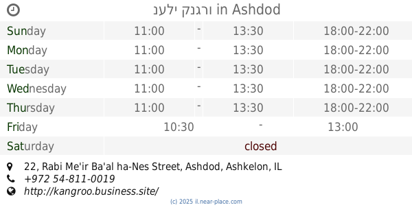
נעלי קנגרו
Rabi Me'ir Ba'al ha-Nes Street 22, Ashdod
Shoe store
read more
1.524 km
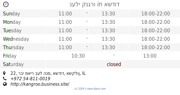
נעלי קנגרו
רבי מאיר בעל הנס 22, אשדוד
Shoe store
read more
1.6 km
ולרי דאנס
Menachem Begin Boulevard 0, Ashdod
Shoe store
read more
1.741 km
גרוסמן נעליים
רבי יהודה הנשיא 8, אשדוד
Shoe store
read more
2.164 km
Фит Степ Про
Tashah Street 9, Ashdod
Shoe store
read more
2.164 km
Фит Степ Про
תש"ח 9, אשדוד
Shoe store
read more
2.818 km
Paola
יהודה הלוי 14, אשדוד
Shoe store
read more
2.866 km
ברוכים אורטופדיה
קניון הסיטי תחנה מרכזית, שדרות מנחם בגין 1, אשדוד
Shoe store
read more
2.87 km
נעלי לנון
יהודה הלוי 14, אשדוד
Shoe store
read more
3.162 km
אילן המכון לאורטופדיה
הבנים 1, אשדוד
Shoe store
read more
3.162 km
אילן המכון לאורטופדיה
HaBanim Street 1, Ashdod
Shoe store
read more
📑
all categories
Accounting
Administrative area level 1
Administrative area level 2
Airport
Amusement park
Aquarium
Art gallery
Atm
Bakery
Bank
Bar
Beauty salon
Bicycle store
Book store
Bowling alley
Bus station
Cafe
Campground
Car dealer
Car rental
Car repair
Car wash
Casino
Cemetery
Church
City hall
Clothing store
Colloquial area
Convenience store
Country
Courthouse
Dentist
Department store
Doctor
Electrician
Electronics store
Embassy
Establishment
Finance
Fire station
Florist
Food
Funeral home
Furniture store
Gas station
General contractor
Grocery or supermarket
Gym
Hair care
Hardware store
Health
Hindu Temple
Home goods store
Hospital
Insurance agency
Intersection
Jewelry store
Laundry
Lawyer
Library
Light rail station
Liquor store
Local government office
Locality
Locksmith
Lodging
Meal delivery
Meal takeaway
Mosque
Movie rental
Movie theater
Moving company
Museum
Natural feature
Neighborhood
Night club
Painter
Park
Parking
Pet store
Pharmacy
Physiotherapist
Place of worship
Plumber
Point of interest
Police
Political
Post office
Premise
Real estate agency
Restaurant
Roofing contractor
Route
Rv park, camping
School
Shoe store
Shopping mall
Spa
Stadium
Storage
Store
Subpremise
Subway station
Supermarket
Synagogue
Taxi stand
Train station
Transit station
Travel agency
University
Veterinary care
Zoo
administrative area level 3
administrative area level 4
sublocality level 1
↑