Colegio cercanos צוללי המזרח התיכון
Israel
Colegio cercanos צוללי המזרח התיכון
צוללי המזרח התיכון
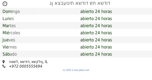
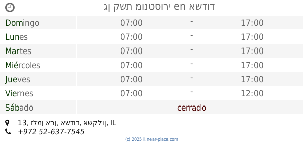
26, Ha-Shayatim Street, Ashdod, Ashkelon, IL Израиль
contactos teléfono
:
+972
Latitude:
31.7991768
, Longitude:
34.6420572
mapa e indicaciones
leer más
Colegio más cercano
200 m
בית ספר ארזים
הרב שאולי 7-15, אשדוד
Colegio
leer más
200 m
בית ספר ארזים
Ha-Rav Sha'uli Street 7-15, Ashdod
Colegio
leer más
293 m
גן אצבעונית אשדוד
האשל, אשדוד
Colegio
leer más
307 m
בית ספר מקיף ג׳ אשדוד
הצוללים 3, אשדוד
Colegio
leer más
355 m
Comprehensive D Ashdod
Bialik Street 10, Ashdod
Colegio
leer más
355 m
מקיף ד' אשדוד
ביאליק 10, אשדוד
Colegio
leer más
423 m
גן קשת מונטסורי
זלמן ארן 13, אשדוד
Colegio
leer más
453 m
גן מיקי מאוס
HaBanim Street, Ashdod
Colegio
leer más
453 m
גן מיקי מאוס
הבנים, אשדוד
Colegio
leer más
542 m
ביס רננים
רח' אבן עזרא 16, אשדוד
Colegio
leer más
546 m
עיריית אשדוד , גן סירונית
אל הציפור 12, אשדוד
Colegio
leer más
612 m
ביס אנקורי
הרצל 1, אשדוד
Colegio
leer más
632 m
Shazar School
Ashdod
Colegio
leer más
674 m
Iq центр
Ha-Rishonim Street 43, Ashdod
Colegio
leer más
696 m
בישבילי אימון לילדים ונוער
Moshe Ibn Ezra Street 23, Ashdod
Colegio
leer más
764 m
Детский сад Дом Яэль
Ha-Atsma'ut Street 2, Ashdod
Colegio
leer más
764 m
Детский сад Дом Яэль
העצמאות 2, אשדוד
Colegio
leer más
765 m
מעון יום אילונית
Ha-Atsma'ut Street 3, Ashdod
Colegio
leer más
773 m
בי״ס היובל
העצמאות 7, אשדוד
Colegio
leer más
773 m
בי״ס היובל
Ha-Atsma'ut Street 7, Ashdod
Colegio
leer más
809 m
בי״ס יסודי גאולים
HaErez Street 6, Ashdod
Colegio
leer más
933 m
Muftan Hermon School
Brenner Street 15, Ashdod
Colegio
leer más
957 m
דינה דרזי- צמיחה רוחנית | מעגלי נשים, אבחון קוד התדר האנושי
אקסודוס 20, אשדוד
Colegio
leer más
971 m
גן ילדים אני גאון
העצמאות 26, אשדוד
Colegio
leer más
1.111 km
HaKirya School
Ha-Atsma'ut Street 63, Ashdod
Colegio
leer más
📑
todas las categorias
Abogado
Acuario
Aeropuerto
Agencia de seguros
Agencia de viajes
Agencia inmobiliaria
Almacenamiento
Almacenar
Alojamiento
Alquiler de coches
Alquiler de películas
Banco
Bar
Barrio
Biblioteca
Bolera
Cafetería
Cajero automático
Característica natural
Casa funeraria
Casino
Cementerio
Centro comercial
Cerrajero
Cine
Club nocturno
Colegio
Comestibles o supermercado
Comida
Comida para llevar
Contabilidad
Contratista de techos
Contratista general
Cuidado del cabello
Cuidado veterinario
De las bicicletas
Dentista
El hospital
Electricista
Embajada
Empresa de mudanzas
Entrega de comidas
Establecimiento
Estacionamiento
Estación de autobuses
Estación de bomberos
Estación de metro
Estación de tren
Estación de tren ligero
Estación de tránsito
Estadio
Farmacia
Ferretería
Financiar
Fisioterapeuta
Florista
Fontanero
Galería de arte
Gasolinera
Gimnasio
Grandes almacenes
Iglesia
Intersección
Joyería
Lavado de autos
Lavandería
Librería
Localidad
Lugar de adoración
Mezquita
Museo
Médico
Nivel 1 área administrativa
Nivel 2 área administrativa
Nivel de sublocality 1
Oficina del gobierno local
Oficina postal
Palacio Municipal
Palacio de justicia
Panadería
Parada de taxi
Parque
Parque de atracciones
Parque de rv, cámping
País
Pintor
Policía
Político
Premisa
Punto de interés
Reparación de autos
Restaurante
Ruta
Salud
Salón de belleza
Sinagoga
Spa
Subpremise
Supermercado
Templo hindú
Terreno de camping
Tienda de artículos para el hogar
Tienda de conveniencia
Tienda de electrónicos
Tienda de licor
Tienda de mascotas
Tienda de muebles
Tienda de ropa
Universidad
Vendedor de autos
Zapatería
Zoo
Área administrativa nivel 3
Área administrativa nivel 4
Área coloquial
↑