School nearby Tehila School
Israel
School nearby Tehila School
Tehila School
Хайфа, Израиль
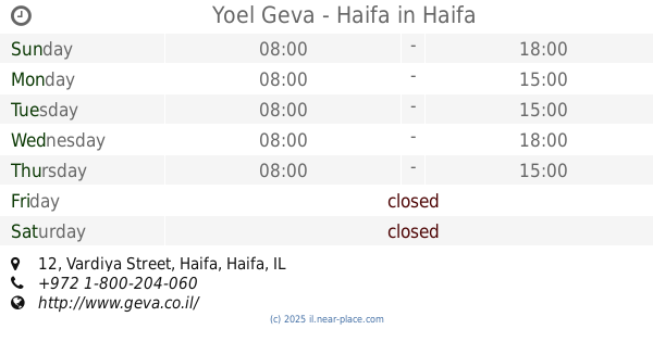
contacts phone
:
+972
Latitude:
32.7871713
, Longitude:
34.9791887
larger map & directions
read more
nearest School
245 m
גן הילדים ליטל פיפל
מיכ"ל 6, חיפה
School
read more
245 m
גן הילדים ליטל פיפל
Mikhal Street 6, Haifa
School
read more
610 m
המרכז למצוינות - ליאור לזר
Khorev Street 1, Haifa
School
read more
671 m
הבית של סימונה
Khorev Street 16, Haifa
School
read more
687 m
The new creative garden
Moriya Boulevard 122, Haifa
School
read more
717 m
גן ארזים
שדרות סיני 9, חיפה
School
read more
717 m
Cedars Park
Sderot Sinai 9, Haifa
School
read more
728 m
גן מור
שדרות סיני 9, חיפה
School
read more
732 m
Haifa levels
Gat Street, Haifa
School
read more
769 m
ביס זיכרון יוסף אחוזה
Sderot Sinai 13, Haifa
School
read more
782 m
גן אחוזת כרמל
דישראלי 12, חיפה
School
read more
802 m
בית רות - מרכז לטיפול בליקויי למידה ע"ש רות פרנקל
34336 3, אילון, חיפה
School
read more
802 m
בית רות - מרכז לטיפול בליקויי למידה עש רות פרנקל
34336, Eilon Street 3, Haifa
School
read more
802 m
בית רות - מרכז לטיפול בליקויי למידה עש רות פרנקל
34336 3, Eilon Street, Haifa
School
read more
809 m
Neot Peres School
Haifa
School
read more
954 m
גן טנדו
Khorev Street 23, Haifa
School
read more
1.062 km
דר ענבל בכלר-סיון קליניקה ללקויות למידה
Albert Einstein Street 25, Haifa
School
read more
1.073 km
אחוזת ילדים
חורב 36, חיפה
School
read more
1.1 km
גן ילדים נאות פרס
Neot Peres, Haifa
School
read more
1.195 km
מעון אמונה
דרך פרויד 42, חיפה
School
read more
1.195 km
Emunah Daycare
Derech Freud 42, Haifa
School
read more
1.814 km
ביס נופים
סורוקה 22, חיפה
School
read more
1.837 km
Yoel Geva - Haifa
Vardiya Street 12, Haifa
School
read more
2.169 km
גן כחל
חיפה
School
read more
2.33 km
גן חמניות
רמב"ן 12, חיפה
School
read more
📑
all categories
Accounting
Administrative area level 1
Administrative area level 2
Airport
Amusement park
Aquarium
Art gallery
Atm
Bakery
Bank
Bar
Beauty salon
Bicycle store
Book store
Bowling alley
Bus station
Cafe
Campground
Car dealer
Car rental
Car repair
Car wash
Casino
Cemetery
Church
City hall
Clothing store
Colloquial area
Convenience store
Country
Courthouse
Dentist
Department store
Doctor
Electrician
Electronics store
Embassy
Establishment
Finance
Fire station
Florist
Food
Funeral home
Furniture store
Gas station
General contractor
Grocery or supermarket
Gym
Hair care
Hardware store
Health
Hindu Temple
Home goods store
Hospital
Insurance agency
Intersection
Jewelry store
Laundry
Lawyer
Library
Light rail station
Liquor store
Local government office
Locality
Locksmith
Lodging
Meal delivery
Meal takeaway
Mosque
Movie rental
Movie theater
Moving company
Museum
Natural feature
Neighborhood
Night club
Painter
Park
Parking
Pet store
Pharmacy
Physiotherapist
Place of worship
Plumber
Point of interest
Police
Political
Post office
Premise
Real estate agency
Restaurant
Roofing contractor
Route
Rv park, camping
School
Shoe store
Shopping mall
Spa
Stadium
Storage
Store
Subpremise
Subway station
Supermarket
Synagogue
Taxi stand
Train station
Transit station
Travel agency
University
Veterinary care
Zoo
administrative area level 3
administrative area level 4
sublocality level 1
↑