School nearby Tabnkin School
Israel
School nearby Tabnkin School
Tabnkin School
Bat Yam Israel
contacts phone
:
+972
Latitude:
32.0134559
, Longitude:
34.7403419
read more
nearest School
126 m
פיסגה
,ישראל, Ha-Sar Shapira Street 35, Bat Yam
School
read more
187 m
גן ילדים טשה
אוסישקין 1-9, בת ים
School
read more
335 m
בי"ס יצחק שדה
בת ים
School
read more
502 m
ביס בני ציון
בת ים
School
read more
502 m
Bnei Tsiyon School
Bat Yam
School
read more
654 m
גן מספנה
יוספטל 21, בת ים
School
read more
684 m
מינימרקט החברים
בר אילן 33, בת ים
School
read more
747 m
Chabad kindergartens and daycare Bat Yam
Arlozorov Street 83, Bat Yam
School
read more
757 m
ביס יעד עמלני
Doctor Nahum Nir Street 28, Bat Yam
School
read more
757 m
ביס יעד עמלני
ד"ר נחום ניר 28, בת ים
School
read more
784 m
Ben Gurion School
Ort Israel Street 16, Bat Yam
School
read more
784 m
Школа Бен Гурион
Ort Israel Street 16, Bat Yam
School
read more
811 m
Tichon Hadash Darca
Israel, Ort Israel Street 9, Bat Yam
School
read more
874 m
IsraelWay University
Ort Israel Street 5, Bat Yam
School
read more
891 m
גן הצוציקים
Yoseftal Street 74, Bat Yam
School
read more
899 m
גן דמבו
החשמונאים 75, בת ים
School
read more
899 m
גן דמבו
HaHashmona'im Street 75, Bat Yam
School
read more
916 m
גן משפחתון וצהרון דידי בת ים
החשמונאים 84, בת ים
School
read more
1.018 km
בייבי גן
החשמונאים 64, בת ים
School
read more
1.034 km
English Academy Fluent האקדמיה לאנגלית
21, Ha-Rav Nisanbaum Street, Bat Yam
School
read more
1.034 km
ЛИДЕРLand
Ha-Rav Nisanbaum Street 21, Bat Yam
School
read more
1.148 km
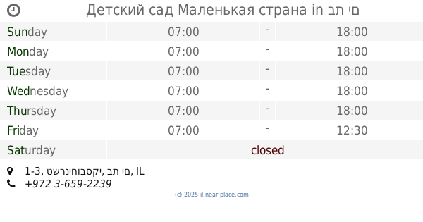
Детский сад Маленькая страна
טשרניחובסקי 1-3, בת ים
School
read more
1.27 km
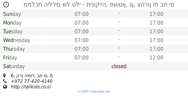
ממלכת הילדים של טלי - תינוקייה, פעוטון, גן, צהרון
קרן היסוד 6, בת ים
School
read more
1.324 km
גן מעון וצהרון "רונית"
דניאל 37, בת ים
School
read more
1.324 km
גן מעון וצהרון רונית
Daniel Street 37, Bat Yam
School
read more
📑
all categories
Accounting
Administrative area level 1
Administrative area level 2
Airport
Amusement park
Aquarium
Art gallery
Atm
Bakery
Bank
Bar
Beauty salon
Bicycle store
Book store
Bowling alley
Bus station
Cafe
Campground
Car dealer
Car rental
Car repair
Car wash
Casino
Cemetery
Church
City hall
Clothing store
Colloquial area
Convenience store
Country
Courthouse
Dentist
Department store
Doctor
Electrician
Electronics store
Embassy
Establishment
Finance
Fire station
Florist
Food
Funeral home
Furniture store
Gas station
General contractor
Grocery or supermarket
Gym
Hair care
Hardware store
Health
Hindu Temple
Home goods store
Hospital
Insurance agency
Intersection
Jewelry store
Laundry
Lawyer
Library
Light rail station
Liquor store
Local government office
Locality
Locksmith
Lodging
Meal delivery
Meal takeaway
Mosque
Movie rental
Movie theater
Moving company
Museum
Natural feature
Neighborhood
Night club
Painter
Park
Parking
Pet store
Pharmacy
Physiotherapist
Place of worship
Plumber
Point of interest
Police
Political
Post office
Premise
Real estate agency
Restaurant
Roofing contractor
Route
Rv park, camping
School
Shoe store
Shopping mall
Spa
Stadium
Storage
Store
Subpremise
Subway station
Supermarket
Synagogue
Taxi stand
Train station
Transit station
Travel agency
University
Veterinary care
Zoo
administrative area level 3
administrative area level 4
sublocality level 1
↑