School nearby Mutanabi School
Israel
School nearby Mutanabi School
Mutanabi School
Маджд-аль-Крум, Израиль
contacts phone
:
+972
Latitude:
32.925828
, Longitude:
35.2626473
larger map & directions
read more
nearest School
101 m
תיכון שאעור
מג'ד אל-כרום
School
read more
158 m
اعداديه محمود درويش
מג'ד אל-כרום
School
read more
158 m
اعداديه محمود درويش
Majd al-Krum
School
read more
287 m
Kindergartens Almgd
Majd al-Krum
School
read more
746 m
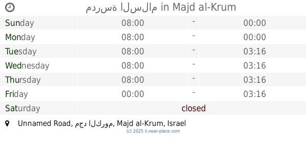
مدرسة السلام
Unnamed Road, مجد الكروم
School
read more
763 m
ביס ב'
בענה
School
read more
783 m
Omar bin al-Khattab School
Majd al-Krum
School
read more
783 m
ביס עומר בן אל ח'טאב
מג'ד אל-כרום
School
read more
930 m
Ibn Khaldun School
Deir al-Asad
School
read more
958 m
كلية البيان
Unnamed Road, البعنة
School
read more
1.011 km
תיכון מקיף
דיר אל-אסד
School
read more
1.011 km
Makif High School
Deir al-Asad
School
read more
1.28 km
ביס א סלאם
מג'ד אל-כרום
School
read more
1.421 km
A school
Bi'ina
School
read more
1.543 km
גן בציר
אביב 57, כרמיאל
School
read more
1.543 km
גן בציר
Aviv Street 57, Karmiel
School
read more
1.575 km
BS Deir al-Asad Al-Ayn
Deir al-Asad
School
read more
1.586 km
المدرسه الاعداديه البعنه
85, בענה
School
read more
1.586 km
المدرسه الاعداديه البعنه
85, Bi'ina
School
read more
1.716 km
גן פעמון
שביל שבט 37, כרמיאל
School
read more
1.994 km
Goren Park - Kindergarten
Asif Street 50, Karmiel
School
read more
2.108 km
School Ziv spindle
Kishor
School
read more
2.141 km
مدرسة ركيفت
רח אסיף 7, כרמיאל
School
read more
2.348 km
CREI סדנה ללימודי צורפות
Derech HaShalom 205, Karmiel
School
read more
2.377 km
בית החינוך אמית
Derech HaShalom 187, Karmiel
School
read more
📑
all categories
Accounting
Administrative area level 1
Administrative area level 2
Airport
Amusement park
Aquarium
Art gallery
Atm
Bakery
Bank
Bar
Beauty salon
Bicycle store
Book store
Bowling alley
Bus station
Cafe
Campground
Car dealer
Car rental
Car repair
Car wash
Casino
Cemetery
Church
City hall
Clothing store
Colloquial area
Convenience store
Country
Courthouse
Dentist
Department store
Doctor
Electrician
Electronics store
Embassy
Establishment
Finance
Fire station
Florist
Food
Funeral home
Furniture store
Gas station
General contractor
Grocery or supermarket
Gym
Hair care
Hardware store
Health
Hindu Temple
Home goods store
Hospital
Insurance agency
Intersection
Jewelry store
Laundry
Lawyer
Library
Light rail station
Liquor store
Local government office
Locality
Locksmith
Lodging
Meal delivery
Meal takeaway
Mosque
Movie rental
Movie theater
Moving company
Museum
Natural feature
Neighborhood
Night club
Painter
Park
Parking
Pet store
Pharmacy
Physiotherapist
Place of worship
Plumber
Point of interest
Police
Political
Post office
Premise
Real estate agency
Restaurant
Roofing contractor
Route
Rv park, camping
School
Shoe store
Shopping mall
Spa
Stadium
Storage
Store
Subpremise
Subway station
Supermarket
Synagogue
Taxi stand
Train station
Transit station
Travel agency
University
Veterinary care
Zoo
administrative area level 3
administrative area level 4
sublocality level 1
↑