School nearby مدرسة ذكور الشاطئ الابتدائية المشتركة (د/ ج) ابو عاصي
Israel
School nearby مدرسة ذكور الشاطئ الابتدائية المشتركة (د/ ج) ابو عاصي
مدرسة ذكور الشاطئ الابتدائية المشتركة (د/ ج) ابو عاصي
Газа
contacts phone
:
+972
Latitude:
31.5372568
, Longitude:
34.4497414
larger map & directions
read more
nearest School
828 m
مدرسة عدنان العلمي الثانوية للبنين
Ghazah
School
read more
921 m
مدرسة النصر الإسلامية النوذجية الخاصة
El-Nasr, Giza
School
read more
1.203 km
مدرسة الرمال الاعدادية للبنين
شارع
School
read more
1.26 km
مدرسة الخزندار
تقاطع شارع العاص مع شارع الشقيري
School
read more
1.26 km
مدرسة غزة الجديدة
Adel Abou Zahra
School
read more
1.622 km
مدرسة سليمان سلطان
Mahmoud Soliman
School
read more
1.684 km
Arafat Secondary School for Gifted School For Boys
غزة-الشيخ رضوان-خلف السوق
School
read more
1.756 km
Al Fakhoora Representative Office
1 8، Илинденци
School
read more
1.765 km
مدرسة الوحيدي لتعليم قيادة السيارات
غزة شارع الثورة شرق المطعم التايلندي
School
read more
1.842 km
مدرسة غزة الجديدة
شارع الشفاء, Hafar Al Batin
School
read more
1.881 km
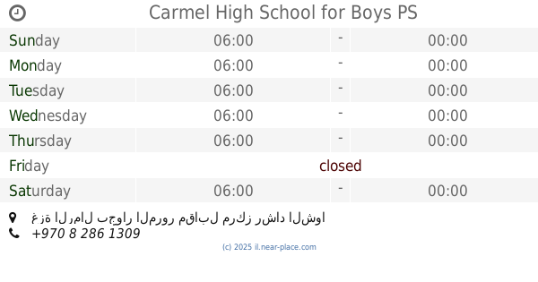
Carmel High School for Boys
غزة الرمال بجوار المرور مقابل مركز رشاد الشوا
School
read more
2.08 km
مدرسة عبد الرحمن بن عوف
الشيخ رضوان شارع الجلاءتقاطع ابشارع الاول
School
read more
2.183 km
مدرسة عبدالملك بن مروان
Tawfik
School
read more
2.187 km
كلية غزة
El-Galaa Street 4
School
read more
2.283 km
مدرسة مصعب بن عمير
بجوار بركة الشيخ رضوان
School
read more
2.374 km
مدرسة عباد الرحمن الخاصة
جباليا، الصفطاوي
School
read more
2.645 km
Alqattan Center
wihda, Al Wahda Street, Sharjah
School
read more
2.665 km
Kindergarten Tomorrow's Pioneers
جباليا ، التوام
School
read more
2.684 km
Qattan Center for the Child
El-Wehda Street، غزة
School
read more
2.867 km
Othman bin Affan Secondary School
School
read more
2.974 km
Slaves Rahman Private School
Jabalia
School
read more
3.006 km
شركة الاسي للتجارة العامة والمقاولات
Popular Street, Drums Crossroads
School
read more
3.51 km
Jabalia Elementary School for Boys
Al Amry Mosque
School
read more
3.896 km
مدرسة الزهرة
الشجاعية حي الدرج
School
read more
4.09 km
Basic Ramleh
مركز شرطة شجاعية
School
read more
📑
all categories
Accounting
Administrative area level 1
Administrative area level 2
Airport
Amusement park
Aquarium
Art gallery
Atm
Bakery
Bank
Bar
Beauty salon
Bicycle store
Book store
Bowling alley
Bus station
Cafe
Campground
Car dealer
Car rental
Car repair
Car wash
Casino
Cemetery
Church
City hall
Clothing store
Colloquial area
Convenience store
Country
Courthouse
Dentist
Department store
Doctor
Electrician
Electronics store
Embassy
Establishment
Finance
Fire station
Florist
Food
Funeral home
Furniture store
Gas station
General contractor
Grocery or supermarket
Gym
Hair care
Hardware store
Health
Hindu Temple
Home goods store
Hospital
Insurance agency
Intersection
Jewelry store
Laundry
Lawyer
Library
Light rail station
Liquor store
Local government office
Locality
Locksmith
Lodging
Meal delivery
Meal takeaway
Mosque
Movie rental
Movie theater
Moving company
Museum
Natural feature
Neighborhood
Night club
Painter
Park
Parking
Pet store
Pharmacy
Physiotherapist
Place of worship
Plumber
Point of interest
Police
Political
Post office
Premise
Real estate agency
Restaurant
Roofing contractor
Route
Rv park, camping
School
Shoe store
Shopping mall
Spa
Stadium
Storage
Store
Subpremise
Subway station
Supermarket
Synagogue
Taxi stand
Train station
Transit station
Travel agency
University
Veterinary care
Zoo
administrative area level 3
administrative area level 4
sublocality level 1
↑