School nearby مدرسة الرسالة الأهلية للعلوم
Israel
School nearby مدرسة الرسالة الأهلية للعلوم
مدرسة الرسالة الأهلية للعلوم
רחוב חסן נימר, שפרעם ישראל
contacts phone
:
+972
Latitude:
32.808426
, Longitude:
35.177911
read more
nearest School
مدرسة الرسالة الأهلية للعلوم
Hasan Nimaer Street, Shefa-'Amr
School
read more
674 m
Sisters of Nazareth School
Ha-Nezirot Street, Shefa-'Amr
School
read more
799 m
בית ספר אלבסליה
Shefa-'Amr
School
read more
799 m
בית ספר אלבסליה
שפרעם
School
read more
922 m
Greek Catholic School
Shefa-'Amr
School
read more
922 m
Greek Catholic School
שפרעם
School
read more
1.199 km
Helen Doron Shefa'amer
440 Street, Shefa-'Amr
School
read more
1.199 km
Helen Doron Shefa'amer
440, שפרעם
School
read more
1.384 km
ביס אל בורג'
שפרעם
School
read more
1.384 km
Al-Burj
Shefa-'Amr
School
read more
1.538 km
ביס יסודי א' שפרעם
שפרעם
School
read more
1.79 km
המכללה הטכנולוגית שפרעם
500, שפרעם
School
read more
1.79 km
Technological College Shefar'am
500, Shefa-'Amr
School
read more
3.495 km
סלון סומיה עבאס
כפר כנא
School
read more
3.655 km
Garden Hill Oaks
Snunit Street, Kiryat Ata
School
read more
3.655 km
גן גבעת אלונים
סנונית, קרית אתא
School
read more
4.721 km
Gepouri Independent School Etzion
Kiryat Ata
School
read more
4.866 km
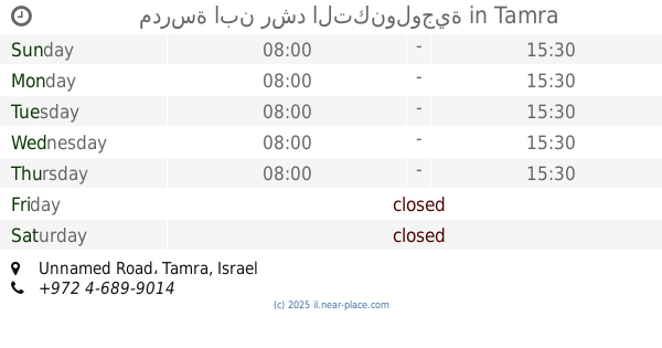
مدرسة ابن رشد التكنولوجية
Unnamed Road, Tamra
School
read more
5.004 km
בית ספר אלבוכארי
Unnamed Road, Tamra
School
read more
5.149 km
B-school
Bir al-Maksur
School
read more
5.663 km
בית ספר יסודי אפק
אפק
School
read more
5.714 km
חט"ב ביר אל מכסור
Bir al-Maksur
School
read more
5.723 km
בית ספר אלח׳וארזמי
טמרה
School
read more
5.782 km
مدرسة المتنبي الاعدادية.
Tamra
School
read more
5.841 km
בית ספר אלראזי ה
Tamra
School
read more
📑
all categories
Accounting
Administrative area level 1
Administrative area level 2
Airport
Amusement park
Aquarium
Art gallery
Atm
Bakery
Bank
Bar
Beauty salon
Bicycle store
Book store
Bowling alley
Bus station
Cafe
Campground
Car dealer
Car rental
Car repair
Car wash
Casino
Cemetery
Church
City hall
Clothing store
Colloquial area
Convenience store
Country
Courthouse
Dentist
Department store
Doctor
Electrician
Electronics store
Embassy
Establishment
Finance
Fire station
Florist
Food
Funeral home
Furniture store
Gas station
General contractor
Grocery or supermarket
Gym
Hair care
Hardware store
Health
Hindu Temple
Home goods store
Hospital
Insurance agency
Intersection
Jewelry store
Laundry
Lawyer
Library
Light rail station
Liquor store
Local government office
Locality
Locksmith
Lodging
Meal delivery
Meal takeaway
Mosque
Movie rental
Movie theater
Moving company
Museum
Natural feature
Neighborhood
Night club
Painter
Park
Parking
Pet store
Pharmacy
Physiotherapist
Place of worship
Plumber
Point of interest
Police
Political
Post office
Premise
Real estate agency
Restaurant
Roofing contractor
Route
Rv park, camping
School
Shoe store
Shopping mall
Spa
Stadium
Storage
Store
Subpremise
Subway station
Supermarket
Synagogue
Taxi stand
Train station
Transit station
Travel agency
University
Veterinary care
Zoo
administrative area level 3
administrative area level 4
sublocality level 1
↑