School nearby Kiryat Bialik Conservatory
Israel
School nearby Kiryat Bialik Conservatory
Kiryat Bialik Conservatory
Кирьят-Бялик, Израиль
contacts phone
:
+972
Latitude:
32.8311533
, Longitude:
35.0961015
larger map & directions
read more
nearest School
קונסרבטוריון קריית ביאליק
קריית ביאליק
School
read more
483 m
מתנס גבעת הרקפות
לוטם, קריית ביאליק
School
read more
483 m
מתנס גבעת הרקפות
Lotem Street, Kiryat Bialik
School
read more
485 m
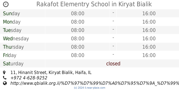
Rakafot Elementry School
Hinanit Street 11, Kiryat Bialik
School
read more
572 m
Ort junior Daphne
Kiryat Bialik
School
read more
578 m
Ort junior Daphne
Dafna Street 54, Kiryat Bialik
School
read more
578 m
אורט דפנה חט"ב
דפנה 54, קריית ביאליק
School
read more
647 m
קונסרבטוריון
דפנה 51, קריית ביאליק
School
read more
647 m
קונסרבטוריון
Dafna Street 51, Kiryat Bialik
School
read more
657 m
חיפה
הערמונים 17, קריית ביאליק
School
read more
657 m
חיפה
HaArmonim Street 17, Kiryat Bialik
School
read more
684 m
גן ברושים
הגנים 4, קריית ביאליק
School
read more
693 m
מורה לפסנתר בקריות
HaShkedim Street 7, Kiryat Bialik
School
read more
693 m
מורה לפסנתר בקריות
השקדים 7, קריית ביאליק
School
read more
955 m
בי"ס נעורים
בנימין 3, קריית ביאליק
School
read more
955 m
Ne'urim School
Binyamin Street 3, Kiryat Bialik
School
read more
1.001 km
בי"ס קדימה
נפתלי 6, קריית ביאליק
School
read more
1.001 km
Kadima School
Naftali Street 6, Kiryat Bialik
School
read more
1.225 km
פעוטון פרפרים /Parparim
Derekh Acre Haifa 139, Kiryat Motzkin
School
read more
1.363 km
תיכון גימנסיה - תיכון פרטי | בית ספר לבגרויות | תיכון בחווית לימודים אחרת
דרך עכו 165, קרית מוצקין
School
read more
1.933 km
בית ספר אחדות
Usha Street 39, Kiryat Motzkin
School
read more
2.172 km
בית הספר קינסרק
Ha-Rishonim Street 1, Kiryat Ata
School
read more
2.199 km
Pinsker School
Kiryat Ata
School
read more
2.423 km
גן מנחם
Yair Street 2, Kiryat Ata
School
read more
2.521 km
תיכון רבין
קרית ים
School
read more
📑
all categories
Accounting
Administrative area level 1
Administrative area level 2
Airport
Amusement park
Aquarium
Art gallery
Atm
Bakery
Bank
Bar
Beauty salon
Bicycle store
Book store
Bowling alley
Bus station
Cafe
Campground
Car dealer
Car rental
Car repair
Car wash
Casino
Cemetery
Church
City hall
Clothing store
Colloquial area
Convenience store
Country
Courthouse
Dentist
Department store
Doctor
Electrician
Electronics store
Embassy
Establishment
Finance
Fire station
Florist
Food
Funeral home
Furniture store
Gas station
General contractor
Grocery or supermarket
Gym
Hair care
Hardware store
Health
Hindu Temple
Home goods store
Hospital
Insurance agency
Intersection
Jewelry store
Laundry
Lawyer
Library
Light rail station
Liquor store
Local government office
Locality
Locksmith
Lodging
Meal delivery
Meal takeaway
Mosque
Movie rental
Movie theater
Moving company
Museum
Natural feature
Neighborhood
Night club
Painter
Park
Parking
Pet store
Pharmacy
Physiotherapist
Place of worship
Plumber
Point of interest
Police
Political
Post office
Premise
Real estate agency
Restaurant
Roofing contractor
Route
Rv park, camping
School
Shoe store
Shopping mall
Spa
Stadium
Storage
Store
Subpremise
Subway station
Supermarket
Synagogue
Taxi stand
Train station
Transit station
Travel agency
University
Veterinary care
Zoo
administrative area level 3
administrative area level 4
sublocality level 1
↑