School nearby خلة المية
Israel
School nearby خلة المية
خلة المية
Yata
contacts phone
:
+972
Latitude:
31.44415
, Longitude:
35.090105
larger map & directions
read more
nearest School
2.359 km
مدرسة ذكور ضرار بن الأزور الأساسية
شارع أم الجرفان
School
read more
4.693 km
مدرسة ذكور السموع الثانوية
Samou Street, يطا
School
read more
4.846 km
Male Bukhari Elementary School
as-Samu
School
read more
4.987 km
مدرسة مؤتة - فراس حوامدة
School
read more
5.232 km
مدرسة بنات السموع الثانوية
as-Samu
School
read more
5.405 km
مدرسة ذكور جعفر بن أبي طالب الأساسية
as-Samu
School
read more
5.43 km
simya school
31°25'04.5"N 35°02'30.6"E
School
read more
5.43 km
مدرسة السيميا
31°25'04.5"N 35°02'30.6"E
School
read more
5.443 km
School males Ibn Khaldun basic
as-Samu
School
read more
7.185 km
School of the pioneers of knowledge of excellence
Hebron Street, Ari'el
School
read more
7.185 km
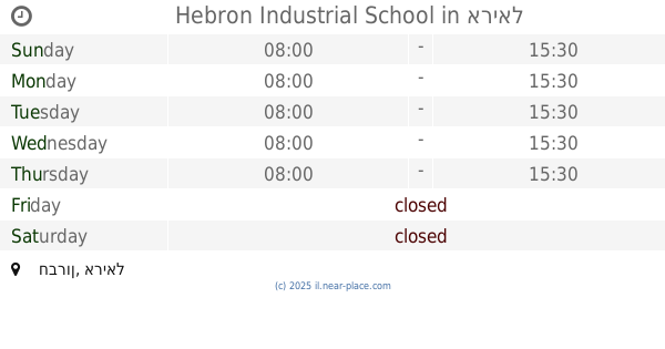
Hebron Industrial School
חברון, אריאל
School
read more
7.687 km
مدرسة القدس المختلطة
Yafa
School
read more
8.351 km
مدرسة الشافعي للبنين
شارع الحاووز الأول بجانب مركز شرطة الحاووز
School
read more
8.416 km
مدرسة الشهيد عبد العزيز
חברון, אריאל
School
read more
8.72 km
مدرسة خديجة بنت خويلد
חברון, אריאל
School
read more
8.72 km
مدرسة خديجة بنت خويلد
Hebron Street, Ari'el
School
read more
8.813 km
مدرسة جوهر
חברון, אריאל
School
read more
9.134 km
مدرسة الحاج زياد جابر
Hebron
School
read more
9.971 km
Haj Rab'i Elementary School for Girls
School
read more
10.398 km
مدرسة الحاجة نظيرة ابو رميلة
School
read more
10.753 km
مدرسة شهداء الحرم الاساسية للبنات
31°31'51.4"N, 东环五巷, 龙岩市
School
read more
11.439 km
ישיבה תיכונית אור מנחם
קרית ארבע
School
read more
12.62 km
Al-Sayyed School
Al Remaia
School
read more
12.623 km
School for Boys Mr. fundamental
ضاحية الرامة الخليل فلسطين
School
read more
19.539 km
מעון חב"ד מיתר
דרך מיתר 71, מיתר
School
read more
📑
all categories
Accounting
Administrative area level 1
Administrative area level 2
Airport
Amusement park
Aquarium
Art gallery
Atm
Bakery
Bank
Bar
Beauty salon
Bicycle store
Book store
Bowling alley
Bus station
Cafe
Campground
Car dealer
Car rental
Car repair
Car wash
Casino
Cemetery
Church
City hall
Clothing store
Colloquial area
Convenience store
Country
Courthouse
Dentist
Department store
Doctor
Electrician
Electronics store
Embassy
Establishment
Finance
Fire station
Florist
Food
Funeral home
Furniture store
Gas station
General contractor
Grocery or supermarket
Gym
Hair care
Hardware store
Health
Hindu Temple
Home goods store
Hospital
Insurance agency
Intersection
Jewelry store
Laundry
Lawyer
Library
Light rail station
Liquor store
Local government office
Locality
Locksmith
Lodging
Meal delivery
Meal takeaway
Mosque
Movie rental
Movie theater
Moving company
Museum
Natural feature
Neighborhood
Night club
Painter
Park
Parking
Pet store
Pharmacy
Physiotherapist
Place of worship
Plumber
Point of interest
Police
Political
Post office
Premise
Real estate agency
Restaurant
Roofing contractor
Route
Rv park, camping
School
Shoe store
Shopping mall
Spa
Stadium
Storage
Store
Subpremise
Subway station
Supermarket
Synagogue
Taxi stand
Train station
Transit station
Travel agency
University
Veterinary care
Zoo
administrative area level 3
administrative area level 4
sublocality level 1
↑