School nearby Keshet School
Coronavirus disease (COVID-19) Situation
confirmed cases
4841772
deaths
12707
Israel
School nearby Keshet School
Keshet School
11, Tishrei Street, Ashdod, Ashkelon, IL Израиль
contacts phone
:
+972 8-864-9618
website:
www.keshetschool.edu2.org.il
Latitude:
31.7812354
, Longitude:
34.641392
larger map & directions
read more
nearest School
209 m
בית חלומותי - גני ילדים ומעונות יום בעמ
אדר 4, אשדוד
School
read more
319 m
גן לילך
המרי, אשדוד
School
read more
337 m
גן אשכל ענבלים
הציונות 85, אשדוד
School
read more
367 m
גן ברוש אשדוד
David HaMelech Street 12, Ashdod
School
read more
490 m
גן רעות
אשדוד
School
read more
490 m
גן רעות
Ashdod
School
read more
511 m
Yahad
אשדוד
School
read more
526 m
גן אחווה
אשדוד
School
read more
551 m
מקיף ט'
Shevet Re'uven Street 2, Ashdod
School
read more
608 m
TET HIGH SCHOOL
שבט ראובן, אשדוד
School
read more
648 m
Садик Улыбки
Ha-Tsiyonut Street 47, Ashdod
School
read more
660 m
בית חינוך תיכון אמי"ת י'
נחל שניר 1, אשדוד
School
read more
738 m
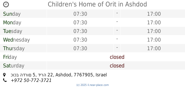
Children's Home of Orit
כוכב הדרום 5, דירה 22, Ashdod
School
read more
738 m
המשפחתון של אורית
כוכב הדרום 5, דירה 22, אשדוד
School
read more
747 m
בי"ס יסודי אמירים
העלייה 3, אשדוד
School
read more
747 m
Amirim School
Ha-Aliya Street 3, Ashdod
School
read more
771 m
ביס רתמים
המלך חזקיה 22, אשדוד
School
read more
820 m
בית ספר לנהיגה גנים באשדוד
תש"ח 11, אשדוד
School
read more
820 m
בית ספר לנהיגה גנים באשדוד
Tashah Street 11, Ashdod
School
read more
852 m
Berlitz Language School
Hagshama Street 2, Ashdod
School
read more
866 m
Elementary School Hofit
Harei Golan Street 4, Ashdod
School
read more
866 m
ביס ממלכתי חופית
הרי גולן 4, אשדוד
School
read more
1.075 km
בישבילי אימון ילדים ונוער
בית הרופאים, Ashdod
School
read more
1.231 km
בית ספר לאומנויות צמח
Ha-Rotem Street 33, Ashdod
School
read more
1.27 km
מקיף ה' אשדוד
הרותם 31, אשדוד
School
read more
📑
all categories
Accounting
Administrative area level 1
Administrative area level 2
Airport
Amusement park
Aquarium
Art gallery
Atm
Bakery
Bank
Bar
Beauty salon
Bicycle store
Book store
Bowling alley
Bus station
Cafe
Campground
Car dealer
Car rental
Car repair
Car wash
Casino
Cemetery
Church
City hall
Clothing store
Colloquial area
Convenience store
Country
Courthouse
Dentist
Department store
Doctor
Electrician
Electronics store
Embassy
Establishment
Finance
Fire station
Florist
Food
Funeral home
Furniture store
Gas station
General contractor
Grocery or supermarket
Gym
Hair care
Hardware store
Health
Hindu Temple
Home goods store
Hospital
Insurance agency
Intersection
Jewelry store
Laundry
Lawyer
Library
Light rail station
Liquor store
Local government office
Locality
Locksmith
Lodging
Meal delivery
Meal takeaway
Mosque
Movie rental
Movie theater
Moving company
Museum
Natural feature
Neighborhood
Night club
Painter
Park
Parking
Pet store
Pharmacy
Physiotherapist
Place of worship
Plumber
Point of interest
Police
Political
Post office
Premise
Real estate agency
Restaurant
Roofing contractor
Route
Rv park, camping
School
Shoe store
Shopping mall
Spa
Stadium
Storage
Store
Subpremise
Subway station
Supermarket
Synagogue
Taxi stand
Train station
Transit station
Travel agency
University
Veterinary care
Zoo
administrative area level 3
administrative area level 4
sublocality level 1
↑