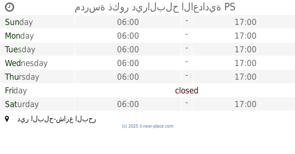
School nearby Kamal Adwan School
Israel
School nearby Kamal Adwan School
Kamal Adwan School
Tall As-Sultan Street, Irbid
contacts phone
:
+970 8 215 1025
Latitude:
31.3106419
, Longitude:
34.2399641
larger map & directions
read more
nearest School
393 m
Jeddah Primary School
الحي السعودي 1
School
read more
404 m
Qadisiyah School
Prince Mohammed Bin Fahd Road, Dammam
School
read more
2.384 km
Mosque of Ali bin Abi Talib Rafah
Mosqué Ali Ben Abi Taleb, N6, Reggane
School
read more
2.681 km
مديرية تعليم رفح
شارع حسين طه الزر
School
read more
5.082 km
School Shafa Amr and Deir Yassin
Rafah
School
read more
5.183 km
مدرسة المسمية النصر رفح
Rabat St, Sana'a
School
read more
6.13 km
مدرسة الاسراء
Al Dahra, Khan Yunis
School
read more
6.225 km
مدرسة طارق ابن زياد
School
read more
6.443 km
مدسة احمد عبد العزيز الجديدة
31°20'42.8"N 34°17'39.9"E
School
read more
6.496 km
مدرسة الشيخ جميل
31°20'45.4"N 34°17'40.1"E
School
read more
6.509 km
مدرسة الحوراني
School
read more
6.535 km
مدرسة عكا
School
read more
6.548 km
مدرسة عكا للبنات
31°20'54.3"N 34°17'34.3"E
School
read more
6.566 km
مدرسة حياه
School
read more
7.31 km
Jinan School
4 9، חיפה
School
read more
7.532 km
مدرسة هارون الرشيد
School
read more
7.591 km
مدرسة الفخاري
Brookfield Place, الاوربي, Bay Street 161, Toronto
School
read more
8.107 km
مدرسة البرش
Bani Suheila
School
read more
11.219 km
روضة ريحانة كيدز
شارع صلاح الدين، خان يونس
School
read more
11.618 km
مدرسة عيلبون الثانوية للبنات غزة
رقم 2, طريق القرارة
School
read more
15.229 km
School martyrs of Deir al-Balah Secondary Girls
شارع الشهيد عبد الكريم العكلوك، قطاع غزّة
School
read more
15.679 km
مدرسة ذكور ديرالبلح الاعدادية
دير البلح-شارع البحر
School
read more
15.699 km
مدرسة العائشية
Deir al Balah
School
read more
15.735 km
مدرسة الشهيد عبد الكريم العكلوك
شارع الشهيد عبد الكريم العكلوك
School
read more
20.175 km
مدرسه خالد بن الوليد
شارع العشرين، نصيرات، الوسطى
School
read more
📑
all categories
Accounting
Administrative area level 1
Administrative area level 2
Airport
Amusement park
Aquarium
Art gallery
Atm
Bakery
Bank
Bar
Beauty salon
Bicycle store
Book store
Bowling alley
Bus station
Cafe
Campground
Car dealer
Car rental
Car repair
Car wash
Casino
Cemetery
Church
City hall
Clothing store
Colloquial area
Convenience store
Country
Courthouse
Dentist
Department store
Doctor
Electrician
Electronics store
Embassy
Establishment
Finance
Fire station
Florist
Food
Funeral home
Furniture store
Gas station
General contractor
Grocery or supermarket
Gym
Hair care
Hardware store
Health
Hindu Temple
Home goods store
Hospital
Insurance agency
Intersection
Jewelry store
Laundry
Lawyer
Library
Light rail station
Liquor store
Local government office
Locality
Locksmith
Lodging
Meal delivery
Meal takeaway
Mosque
Movie rental
Movie theater
Moving company
Museum
Natural feature
Neighborhood
Night club
Painter
Park
Parking
Pet store
Pharmacy
Physiotherapist
Place of worship
Plumber
Point of interest
Police
Political
Post office
Premise
Real estate agency
Restaurant
Roofing contractor
Route
Rv park, camping
School
Shoe store
Shopping mall
Spa
Stadium
Storage
Store
Subpremise
Subway station
Supermarket
Synagogue
Taxi stand
Train station
Transit station
Travel agency
University
Veterinary care
Zoo
administrative area level 3
administrative area level 4
sublocality level 1
↑