School nearby חטב השחר
Israel
School nearby חטב השחר
חטב השחר
36, רח השחר, הוד השרון, פתח תקווה, IL Израиль
contacts phone
:
+972 9-740-6045
website:
www.hashahar10.edu1.org.il
Latitude:
32.1504283
, Longitude:
34.8924275
larger map & directions
read more
nearest School
60 m
Lapid Elementary School
Ha-Shakhar Street 34, Hod Hasharon
School
read more
60 m
בית ספר לפיד
השחר 34, הוד השרון
School
read more
205 m
Garden Tidhar
Noga Alley 5, Hod Hasharon
School
read more
320 m
סטודיו למחול זוהר
Ramatayim Road 108, Hod Hasharon
School
read more
320 m
סטודיו למחול זוהר
דרך רמתיים 108, הוד השרון
School
read more
552 m
גן אלון
סמטת האלון 6, הוד השרון
School
read more
652 m
Hod Hasharon Zen Center
Ha-Tkhelet Street 16, Hod Hasharon
School
read more
680 m
Hadarim High School
Jabotinski Street 4, Hod Hasharon
School
read more
680 m
בית ספר תיכון הדרים
ז'בוטינסקי 4, הוד השרון
School
read more
686 m
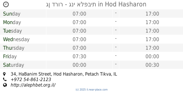
גן דרור - גני אלפבית
HaBanim Street 34, Hod Hasharon
School
read more
701 m
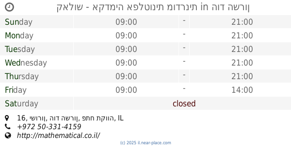
קאלוש - אקדמיה אפלטונית מודרנית
ישורון 16, הוד השרון
School
read more
728 m
Hana Paz-Expert in Learning Disabilities
הגאולה 14, הוד השרון
School
read more
801 m
ילדי המים
Derech HaBrosh 6, Yarkona
School
read more
801 m
ילדי המים
דרך הברוש 6, ירקונה
School
read more
824 m
גן תמרים
משאבים 15, הוד השרון
School
read more
868 m
פרויקט הילה
דרך רמתיים 47, הוד השרון
School
read more
902 m
כפר הנוער מוסינזון
עליית הנוער 1, הוד השרון
School
read more
908 m
Democratic School
HaBanim Street 53, Hod Hasharon
School
read more
929 m
Alexander Muss High School in Israel
Aliyat Hano'ar Street 1, Hod Hasharon
School
read more
952 m
אוריגני
בית העם 30, גני עם
School
read more
1.069 km
חטיבת ביניים הראשונים
רח' פדויים 16, הוד השרון
School
read more
1.113 km
גן ניצן אביב
Hod Hasharon
School
read more
1.113 km
גן ניצן אביב
הוד השרון
School
read more
1.201 km
גן סייפן
הארבל 1-7, הוד השרון
School
read more
1.201 km
Saifun Garden
Ha-Arbel Street 1-7, Hod Hasharon
School
read more
📑
all categories
Accounting
Administrative area level 1
Administrative area level 2
Airport
Amusement park
Aquarium
Art gallery
Atm
Bakery
Bank
Bar
Beauty salon
Bicycle store
Book store
Bowling alley
Bus station
Cafe
Campground
Car dealer
Car rental
Car repair
Car wash
Casino
Cemetery
Church
City hall
Clothing store
Colloquial area
Convenience store
Country
Courthouse
Dentist
Department store
Doctor
Electrician
Electronics store
Embassy
Establishment
Finance
Fire station
Florist
Food
Funeral home
Furniture store
Gas station
General contractor
Grocery or supermarket
Gym
Hair care
Hardware store
Health
Hindu Temple
Home goods store
Hospital
Insurance agency
Intersection
Jewelry store
Laundry
Lawyer
Library
Light rail station
Liquor store
Local government office
Locality
Locksmith
Lodging
Meal delivery
Meal takeaway
Mosque
Movie rental
Movie theater
Moving company
Museum
Natural feature
Neighborhood
Night club
Painter
Park
Parking
Pet store
Pharmacy
Physiotherapist
Place of worship
Plumber
Point of interest
Police
Political
Post office
Premise
Real estate agency
Restaurant
Roofing contractor
Route
Rv park, camping
School
Shoe store
Shopping mall
Spa
Stadium
Storage
Store
Subpremise
Subway station
Supermarket
Synagogue
Taxi stand
Train station
Transit station
Travel agency
University
Veterinary care
Zoo
administrative area level 3
administrative area level 4
sublocality level 1
↑