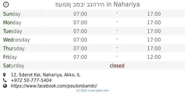
School nearby הגן שלנו הגן הדו לשוני
Israel
School nearby הגן שלנו הגן הדו לשוני
הגן שלנו הגן הדו לשוני
12, Sderot Kei, Nahariya, Akko, IL Израиль
contacts phone
:
+972 54-656-7735
Latitude:
32.9978889
, Longitude:
35.0923759
larger map & directions
read more
nearest School
הגן שלנו הגן הדו לשוני
שדרות קיי 12, נהריה
School
read more
25 m
פעוטון במבי בנהריה
שדרות קיי 12 נהריה IL 2244830, Sderot Kei 12, Nahariyya
School
read more
25 m
פעוטון במבי בנהריה
שדרות קיי 12 נהריה IL 2244830, שדרות קיי 12, נהריה
School
read more
229 m
Golda Meir School
Balfour Street 71, Nahariyya
School
read more
249 m
גנון חוויה
Kaplan Street 11, Nahariyya
School
read more
249 m
גנון חוויה
קפלן 11, נהריה
School
read more
302 m
גן נופר
נהריה
School
read more
467 m
גננו הקטן
נחום סוקולוב 38-44, נהריה
School
read more
568 m
בי"ס מנחם בגין
נהריה
School
read more
641 m
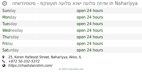
החשדניסטים - מקצועות העולם אנשי העולם החדש
Keren HaYesod Street 25, Nahariyya
School
read more
664 m
גן הילה של אושר
וייצמן 81, נהריה
School
read more
670 m
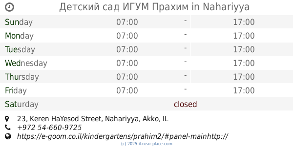
Детский сад ИГУМ Прахим
קרן היסוד 23, נהריה
School
read more
670 m
Детский сад ИГУМ Прахим
Keren HaYesod Street 23, Nahariyya
School
read more
714 m
Even Shoham School
Nahariyya
School
read more
866 m
School Weizmann Nahariya
David Remez Street 2-22, Nahariyya
School
read more
1.009 km
איזימט EZmath
Sderot HaGa'aton 28, Nahariyya
School
read more
1.009 km
איזימט EZmath
שדרות הגעתון 28, נהריה
School
read more
1.033 km
Rushonim, Центр развития
נהריה
School
read more
1.033 km
Rushonim, Центр развития
Nahariyya
School
read more
1.033 km
Rishonim, Центр развития
Nahariyya
School
read more
1.048 km
בי"ס אוסישקין
נהריה
School
read more
1.048 km
Ussishkin School
Nahariyya
School
read more
1.112 km
בית חינוך אופק
ד.נ. גליל מערבי, Evron
School
read more
1.158 km
Ofek School
עברון
School
read more
1.237 km
קלאב קידס נהריה
השקד 16, נהריה
School
read more
📑
all categories
Accounting
Administrative area level 1
Administrative area level 2
Airport
Amusement park
Aquarium
Art gallery
Atm
Bakery
Bank
Bar
Beauty salon
Bicycle store
Book store
Bowling alley
Bus station
Cafe
Campground
Car dealer
Car rental
Car repair
Car wash
Casino
Cemetery
Church
City hall
Clothing store
Colloquial area
Convenience store
Country
Courthouse
Dentist
Department store
Doctor
Electrician
Electronics store
Embassy
Establishment
Finance
Fire station
Florist
Food
Funeral home
Furniture store
Gas station
General contractor
Grocery or supermarket
Gym
Hair care
Hardware store
Health
Hindu Temple
Home goods store
Hospital
Insurance agency
Intersection
Jewelry store
Laundry
Lawyer
Library
Light rail station
Liquor store
Local government office
Locality
Locksmith
Lodging
Meal delivery
Meal takeaway
Mosque
Movie rental
Movie theater
Moving company
Museum
Natural feature
Neighborhood
Night club
Painter
Park
Parking
Pet store
Pharmacy
Physiotherapist
Place of worship
Plumber
Point of interest
Police
Political
Post office
Premise
Real estate agency
Restaurant
Roofing contractor
Route
Rv park, camping
School
Shoe store
Shopping mall
Spa
Stadium
Storage
Store
Subpremise
Subway station
Supermarket
Synagogue
Taxi stand
Train station
Transit station
Travel agency
University
Veterinary care
Zoo
administrative area level 3
administrative area level 4
sublocality level 1
↑