School nearby حضانة ليوشاגן ליושה
Israel
School nearby حضانة ليوشاגן ליושה
حضانة ليوشاגן ליושה
Исфия, Израиль
contacts phone
:
+972 52-373-0627
Latitude:
32.7166084
, Longitude:
35.0616116
larger map & directions
read more
nearest School
520 m
מרכז אנגלית קטרינה מארון
עיספיא
School
read more
520 m
מרכז אנגלית קטרינה מארון
Isfiya
School
read more
573 m
Indoor sports hall
Isfiya
School
read more
573 m
אולם ספורט מקורה
עיספיא
School
read more
581 m
בית ספר אורט חטה עספייא
Isfiya
School
read more
1.224 km
בית ספר אורט רונסון
Isfiya
School
read more
1.338 km
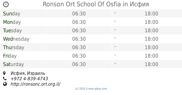
Ronson Ort School Of Osfia
Isfiya
School
read more
1.348 km
בית ספר יסודי א עוספיא
עוספיא, Isfiya
School
read more
1.353 km
בית ספר חטב אלאשראק
Isfiya
School
read more
1.359 km
בית ספר יסודי אלאשראק
עיספיא
School
read more
1.359 km
בית ספר יסודי אלאשראק
Isfiya
School
read more
1.485 km
בית ספר מסא
Unnamed Road, עיספיא
School
read more
1.485 km
בית ספר מס"א
Unnamed Road, Isfiya
School
read more
2.268 km
קרמיקה עוספייה
Isfiya
School
read more
2.344 km
جمعية فأس التعاونية
672, Daliyat al-Karmel
School
read more
3.648 km
ביס כרמל זבולון
יגור
School
read more
3.648 km
Carmel Zevulun School
Yagur
School
read more
3.699 km
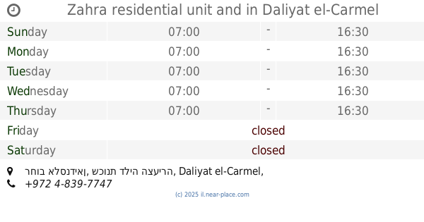
Zahra residential unit and
רחוב אלסנדיאן, שכונת דליה הצעירה, Daliyat al-Karmel
School
read more
3.894 km
בית ספר עתיד טכנולוגי
Daliyat al-Karmel
School
read more
4.639 km
גל כתב- בית ספר למאלפי כלבים ופנסיון פתוח לכלבים
Kfar Hasidim
School
read more
4.952 km
גבינות מהלב
36851, העלייה 24, נשר
School
read more
5.114 km
The wisdom of Israel
מעלה צוהר 3, רכסים
School
read more
5.535 km
מגרש הדרכה כרמל בטיחות
כפר חסידים א'
School
read more
5.688 km
Ohel Sara School for girls
Rekhasim
School
read more
6.057 km
Tauber Bioinformatics Research Center
Haifa
School
read more
📑
all categories
Accounting
Administrative area level 1
Administrative area level 2
Airport
Amusement park
Aquarium
Art gallery
Atm
Bakery
Bank
Bar
Beauty salon
Bicycle store
Book store
Bowling alley
Bus station
Cafe
Campground
Car dealer
Car rental
Car repair
Car wash
Casino
Cemetery
Church
City hall
Clothing store
Colloquial area
Convenience store
Country
Courthouse
Dentist
Department store
Doctor
Electrician
Electronics store
Embassy
Establishment
Finance
Fire station
Florist
Food
Funeral home
Furniture store
Gas station
General contractor
Grocery or supermarket
Gym
Hair care
Hardware store
Health
Hindu Temple
Home goods store
Hospital
Insurance agency
Intersection
Jewelry store
Laundry
Lawyer
Library
Light rail station
Liquor store
Local government office
Locality
Locksmith
Lodging
Meal delivery
Meal takeaway
Mosque
Movie rental
Movie theater
Moving company
Museum
Natural feature
Neighborhood
Night club
Painter
Park
Parking
Pet store
Pharmacy
Physiotherapist
Place of worship
Plumber
Point of interest
Police
Political
Post office
Premise
Real estate agency
Restaurant
Roofing contractor
Route
Rv park, camping
School
Shoe store
Shopping mall
Spa
Stadium
Storage
Store
Subpremise
Subway station
Supermarket
Synagogue
Taxi stand
Train station
Transit station
Travel agency
University
Veterinary care
Zoo
administrative area level 3
administrative area level 4
sublocality level 1
↑