School nearby גן אצטרובל
Israel
School nearby גן אצטרובל
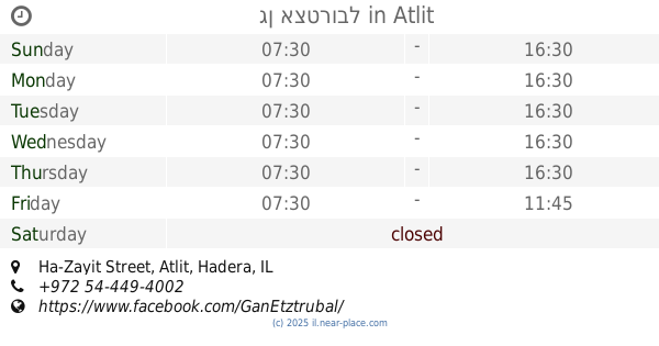
גן אצטרובל
הזית, עתלית, חדרה, IL ישראל
contacts phone
:
+972 54-449-4002
website:
www.facebook.com
Latitude:
32.686176
, Longitude:
34.9422322
larger map & directions
read more
nearest School
גן אצטרובל
69, Ha-Zayit Street, Atlit
School
read more
110 m
Activities for children Flower
Shoshanat HaYam Street 138/4, Atlit
School
read more
110 m
הפעלות לילדים פרח
שושנת הים 138/4, עתלית
School
read more
385 m
גן נרקיס
גבעת הבריכות 11-33, עתלית
School
read more
385 m
גן נרקיס
Giv'at HaBreichot Street 11-33, Atlit
School
read more
396 m
גן כלנית
גבעת הבריכות 33, עתלית
School
read more
396 m
גן כלנית
Giv'at HaBreichot Street 33, Atlit
School
read more
500 m
גן ילדים רקפת
עתלית
School
read more
500 m
גן ילדים רקפת
Atlit
School
read more
1.238 km
ביס אזורי כרמל וים
עין כרמל
School
read more
1.238 km
Carmel Va-Yam Regional School
Ein Carmel
School
read more
1.314 km
בית הספר גלי עתלית החדש
עתלית
School
read more
1.314 km
School new waves of Atlit
Atlit
School
read more
1.326 km
בי"ס גלי עתלית
החיטה 1, עתלית
School
read more
1.57 km
GreenLand Foundation עמותת ארץ ירוקה
נווה ים
School
read more
1.987 km
גן נחלים
נחל גלים 2-8, עתלית
School
read more
1.987 km
גן נחלים
Nahal Galim Street 2-8, Atlit
School
read more
3.822 km
ישיבת שלום אסיריך
פורצי כלא עכו 6, בני ברק
School
read more
4.295 km
Chabad School Carmel Beach
Israel
School
read more
4.295 km
בית ספר חבד חוף הכרמל
Israel
School
read more
4.334 km
Kfar Tzvi Sitrin
99, Megadim
School
read more
4.456 km
ישיבת אור אבנר כפר סיטרין
חוף הכרמל, חדרה
School
read more
4.54 km
ישיבה אור אבנר
Israel
School
read more
4.677 km
Школа Назара
Israel
School
read more
4.775 km
Yemin Orde
Israel
School
read more
📑
all categories
Accounting
Administrative area level 1
Administrative area level 2
Airport
Amusement park
Aquarium
Art gallery
Atm
Bakery
Bank
Bar
Beauty salon
Bicycle store
Book store
Bowling alley
Bus station
Cafe
Campground
Car dealer
Car rental
Car repair
Car wash
Casino
Cemetery
Church
City hall
Clothing store
Colloquial area
Convenience store
Country
Courthouse
Dentist
Department store
Doctor
Electrician
Electronics store
Embassy
Establishment
Finance
Fire station
Florist
Food
Funeral home
Furniture store
Gas station
General contractor
Grocery or supermarket
Gym
Hair care
Hardware store
Health
Hindu Temple
Home goods store
Hospital
Insurance agency
Intersection
Jewelry store
Laundry
Lawyer
Library
Light rail station
Liquor store
Local government office
Locality
Locksmith
Lodging
Meal delivery
Meal takeaway
Mosque
Movie rental
Movie theater
Moving company
Museum
Natural feature
Neighborhood
Night club
Painter
Park
Parking
Pet store
Pharmacy
Physiotherapist
Place of worship
Plumber
Point of interest
Police
Political
Post office
Premise
Real estate agency
Restaurant
Roofing contractor
Route
Rv park, camping
School
Shoe store
Shopping mall
Spa
Stadium
Storage
Store
Subpremise
Subway station
Supermarket
Synagogue
Taxi stand
Train station
Transit station
Travel agency
University
Veterinary care
Zoo
administrative area level 3
administrative area level 4
sublocality level 1
↑