School nearby בית ספר לנהיגה יוזמה
Israel
School nearby בית ספר לנהיגה יוזמה
בית ספר לנהיגה יוזמה
170, ההסתדרות, חולון, IL ישראל
contacts phone
:
+972 3-556-5492
website:
www.yoz-ma.co.il
Latitude:
32.0123925
, Longitude:
34.7898673
larger map & directions
read more
nearest School
21 m
משפחתוגן משפחתון וגן בחולון
Mapu Street 3, Holon
School
read more
21 m
משפחתוגן משפחתון וגן בחולון
מאפו 3, חולון
School
read more
208 m
בית ספר שחר
Perets Smolenskin Street 15, Holon
School
read more
355 m
"פעוטון חב"ד "גולדי
יחזקאל 15, חולון
School
read more
355 m
"Chabad nursery" Goldie
Yekhezkel Street 15, Holon
School
read more
360 m
גן מעון קלודין
החרמון 19 רמת הנשיא, בת ים
School
read more
403 m
בי"ס אשכול
מרבד הקסמים 9, חולון
School
read more
570 m
Детский Сад
Sheshet ha-Yamim Street 17, Holon
School
read more
629 m
תיכון נעמת חולון
Keren Kayemet le-Yisra'el Street 13, Holon
School
read more
749 m
Re'im High School
Nekhemya Street 13, Holon
School
read more
762 m
Moshe Sharett School
משה שרת 38, חולון
School
read more
825 m
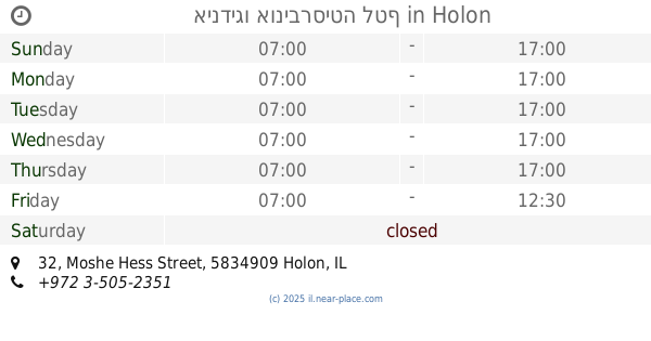
אינדיגו אוניברסיטה לטף
Moshe Hess Street 32, Holon
School
read more
855 m
גן הביצה שהתחפשה
גולדה מאיר 11, חולון
School
read more
891 m
הגן של אפי
Mohiliver Street 15, Holon
School
read more
892 m
גן מעגלים
רפאל איתן 12, חולון
School
read more
900 m
הקטנטנים של עינת
מוהליבר 38 חולון, Holon
School
read more
906 m
גן ילדים לי גן
מוהליבר 36, חולון
School
read more
912 m
גן חבד גולדי
החסידה 4, חולון
School
read more
933 m
Hatavor School
Ha-Tavor Street 1, Holon
School
read more
968 m
בית ספר ניצנים
Ghivat Ha Tahmoset 43, חולון
School
read more
970 m
בית ספר יבנה
Ze'ev Yavets Street, Holon
School
read more
988 m
אשכול גנים - מרגנית
HaMarganit Street 11, Holon
School
read more
1.019 km
גן אלון
המרגנית 11, חולון
School
read more
1.291 km
Shenkar School
Holon
School
read more
1.311 km
ריקודים סלוניים ולטינו אמריקאיים
אחד העם 10, חולון
School
read more
📑
all categories
Accounting
Administrative area level 1
Administrative area level 2
Airport
Amusement park
Aquarium
Art gallery
Atm
Bakery
Bank
Bar
Beauty salon
Bicycle store
Book store
Bowling alley
Bus station
Cafe
Campground
Car dealer
Car rental
Car repair
Car wash
Casino
Cemetery
Church
City hall
Clothing store
Colloquial area
Convenience store
Country
Courthouse
Dentist
Department store
Doctor
Electrician
Electronics store
Embassy
Establishment
Finance
Fire station
Florist
Food
Funeral home
Furniture store
Gas station
General contractor
Grocery or supermarket
Gym
Hair care
Hardware store
Health
Hindu Temple
Home goods store
Hospital
Insurance agency
Intersection
Jewelry store
Laundry
Lawyer
Library
Light rail station
Liquor store
Local government office
Locality
Locksmith
Lodging
Meal delivery
Meal takeaway
Mosque
Movie rental
Movie theater
Moving company
Museum
Natural feature
Neighborhood
Night club
Painter
Park
Parking
Pet store
Pharmacy
Physiotherapist
Place of worship
Plumber
Point of interest
Police
Political
Post office
Premise
Real estate agency
Restaurant
Roofing contractor
Route
Rv park, camping
School
Shoe store
Shopping mall
Spa
Stadium
Storage
Store
Subpremise
Subway station
Supermarket
Synagogue
Taxi stand
Train station
Transit station
Travel agency
University
Veterinary care
Zoo
administrative area level 3
administrative area level 4
sublocality level 1
↑