School nearby בי"ס פסגות
Israel
School nearby בי"ס פסגות
בי"ס פסגות
קריית ביאליק ישראל
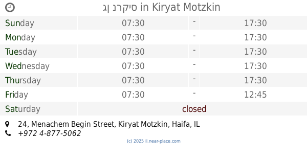
contacts phone
:
+972
Latitude:
32.8545384
, Longitude:
35.0978478
read more
nearest School
Pasgot School
Kiryat Bialik
School
read more
257 m
בית ספר יד"ע
ז'בוטינסקי 30, קריית ביאליק
School
read more
257 m
בית ספר יד"ע
Jabotinski Street 30, Kiryat Bialik
School
read more
271 m
תכנית אדוה המדרשה למנהיגות ציבורית
Ha-Partizanim St. 7, קריית ביאליק
School
read more
472 m
מעון ויצו נווה גנים
דרך עכו חיפה 285, קרית מוצקין
School
read more
472 m
Neve WIZO residence and gardens
Derekh Acre Haifa 285, Kiryat Motzkin
School
read more
593 m
בי"ס עליזה ומנחם בגין
מנחם בגין 26, קרית מוצקין
School
read more
593 m
School Aliza Begin
Menachem Begin Street 26, Kiryat Motzkin
School
read more
631 m
גן נרקיס
מנחם בגין 24, קרית מוצקין
School
read more
631 m
גן נרקיס
Menachem Begin Street 24, Kiryat Motzkin
School
read more
755 m
HaYovel & HaDaffna Kindergartens
Yitskhak Ben Tsvi Street 6, Kiryat Motzkin
School
read more
755 m
HaYovel & HaDaffna Kindergartens
יצחק בן צבי 6, קרית מוצקין
School
read more
1.169 km
Yoel Geva - Kryon
Derekh Acre Haifa 194, Kiryat Bialik
School
read more
1.344 km
גן נוגה
אילנות 10, קרית ים
School
read more
1.344 km
גן נוגה
Ilanot Street 10, Kiryat Yam
School
read more
1.359 km
ביס סביונים
קרית ים
School
read more
1.536 km
גן מאדים
שדרות ארזים, קרית ים
School
read more
1.561 km
גן ערבה
הערבה 50, קרית ים
School
read more
1.58 km
גן צאלון
הגליל 2, קרית ים
School
read more
1.631 km
פלא גן
עדולם 27, קרית ים
School
read more
1.73 km
בי"ס קדימה
נפתלי 6, קריית ביאליק
School
read more
1.772 km
תיכון גימנסיה - תיכון פרטי | בית ספר לבגרויות | תיכון בחווית לימודים אחרת
דרך עכו 165, קרית מוצקין
School
read more
2.088 km
Ульпан
Kadish Luz Street 11, Kiryat Motzkin
School
read more
2.125 km
תיכון רבין
קרית ים
School
read more
2.157 km
ביס יסודי עש יאנוש קורצ'אק
דולצ'ין, קרית מוצקין
School
read more
📑
all categories
Accounting
Administrative area level 1
Administrative area level 2
Airport
Amusement park
Aquarium
Art gallery
Atm
Bakery
Bank
Bar
Beauty salon
Bicycle store
Book store
Bowling alley
Bus station
Cafe
Campground
Car dealer
Car rental
Car repair
Car wash
Casino
Cemetery
Church
City hall
Clothing store
Colloquial area
Convenience store
Country
Courthouse
Dentist
Department store
Doctor
Electrician
Electronics store
Embassy
Establishment
Finance
Fire station
Florist
Food
Funeral home
Furniture store
Gas station
General contractor
Grocery or supermarket
Gym
Hair care
Hardware store
Health
Hindu Temple
Home goods store
Hospital
Insurance agency
Intersection
Jewelry store
Laundry
Lawyer
Library
Light rail station
Liquor store
Local government office
Locality
Locksmith
Lodging
Meal delivery
Meal takeaway
Mosque
Movie rental
Movie theater
Moving company
Museum
Natural feature
Neighborhood
Night club
Painter
Park
Parking
Pet store
Pharmacy
Physiotherapist
Place of worship
Plumber
Point of interest
Police
Political
Post office
Premise
Real estate agency
Restaurant
Roofing contractor
Route
Rv park, camping
School
Shoe store
Shopping mall
Spa
Stadium
Storage
Store
Subpremise
Subway station
Supermarket
Synagogue
Taxi stand
Train station
Transit station
Travel agency
University
Veterinary care
Zoo
administrative area level 3
administrative area level 4
sublocality level 1
↑