School nearby Al Kholpha'a Secondary School
Israel
School nearby Al Kholpha'a Secondary School
Al Kholpha'a Secondary School
President Yaser Arafat
contacts phone
:
+972
Latitude:
31.7031016
, Longitude:
35.1806755
larger map & directions
read more
nearest School
155 m
Muscat Secondary School For Girls
president yasser arafat
School
read more
866 m
Talitha Kumi Educational Center
אל עמל, بيت جالا
School
read more
985 m
Dehesheh Girls School
road transport department near, Hebron Street, Bet Shemesh
School
read more
1.488 km
Al-Amal School
Israel
School
read more
2.003 km
House Of Hope
Hebron Road, Bethlehem
School
read more
2.069 km
Bethlehem International Center of Bethlehem
Avenue Paul Vi, Saint-Raymond
School
read more
2.135 km
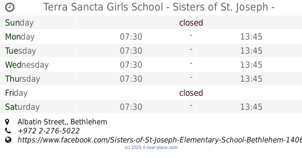
Terra Sancta Girls School - Sisters of St. Joseph - Bethlehem (Elementary School)
Albatin Street,, Bethlehem
School
read more
2.138 km
مدرسة النخبة
Beit Lekhem Street, Rishon LeTsiyon
School
read more
2.235 km
Bic
hosh abu jarour, Star Street, Bethlehem
School
read more
2.269 km
Terra Sancta Girls School - Sisters of St. Joseph - Bethlehem (Secondary School)
Manger Street
School
read more
3.011 km
Gilo Unified School for Science and the Arts
Jerusalem
School
read more
3.011 km
ביס גילה מאוחד למדעים ואמנות
ירושלים
School
read more
3.128 km
תיכון ארץ הצבי גילה
הגננת 29, Jerusalem
School
read more
3.128 km
תיכון ארץ הצבי גילה
HaGanenet Street 29, Jerusalem
School
read more
3.128 km
Eretz Hatzvi High School Gilo
HaGanenet Street 29, Jerusalem
School
read more
3.188 km
The boy Amit House
HaShayish Street 9, Jerusalem
School
read more
3.188 km
בית הילד אמית
השיש 9, ירושלים
School
read more
3.37 km
ויצו גילה-הנופך
HaNofech Street, Jerusalem
School
read more
3.607 km
School Gilo as an official religious institution
Jerusalem
School
read more
3.607 km
ביס גילה ב' ממד
ירושלים
School
read more
3.794 km
Greek Catholic Patriarchate School Peter Nettekoven Beit Sahour
School
read more
3.855 km
School Obiyat
هندازة
School
read more
3.958 km
מכינת ארז ירושלים
Vardinon Street 14, Jerusalem
School
read more
3.983 km
ביס תלי גילה
ורדינון 1, ירושלים
School
read more
4.804 km
תלמוד תורה אריאל ארץ המוריה (ער)
הרב מן ההר 16, ירושלים
School
read more
📑
all categories
Accounting
Administrative area level 1
Administrative area level 2
Airport
Amusement park
Aquarium
Art gallery
Atm
Bakery
Bank
Bar
Beauty salon
Bicycle store
Book store
Bowling alley
Bus station
Cafe
Campground
Car dealer
Car rental
Car repair
Car wash
Casino
Cemetery
Church
City hall
Clothing store
Colloquial area
Convenience store
Country
Courthouse
Dentist
Department store
Doctor
Electrician
Electronics store
Embassy
Establishment
Finance
Fire station
Florist
Food
Funeral home
Furniture store
Gas station
General contractor
Grocery or supermarket
Gym
Hair care
Hardware store
Health
Hindu Temple
Home goods store
Hospital
Insurance agency
Intersection
Jewelry store
Laundry
Lawyer
Library
Light rail station
Liquor store
Local government office
Locality
Locksmith
Lodging
Meal delivery
Meal takeaway
Mosque
Movie rental
Movie theater
Moving company
Museum
Natural feature
Neighborhood
Night club
Painter
Park
Parking
Pet store
Pharmacy
Physiotherapist
Place of worship
Plumber
Point of interest
Police
Political
Post office
Premise
Real estate agency
Restaurant
Roofing contractor
Route
Rv park, camping
School
Shoe store
Shopping mall
Spa
Stadium
Storage
Store
Subpremise
Subway station
Supermarket
Synagogue
Taxi stand
Train station
Transit station
Travel agency
University
Veterinary care
Zoo
administrative area level 3
administrative area level 4
sublocality level 1
↑