Restaurant nearby צ'יקין אין גאולה
Israel
Restaurant nearby צ'יקין אין גאולה
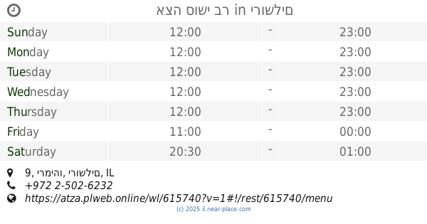
צ'יקין אין גאולה
יעקב מאיר, ירושלים ישראל
contacts phone
:
+972
Latitude:
31.7882538
, Longitude:
35.2158773
read more
nearest Restaurant
262 m
פינוקים
מאה שערים 1, ירושלים
Restaurant
read more
314 m
פלאפל עוזי
Yisha'ayahu Street 10, Jerusalem
Restaurant
read more
512 m
שיפודי מוריס
Beit Ya'akov Street 4, Jerusalem
Restaurant
read more
513 m
ג'קט פוטטו בר
בית יעקב 5, ירושלים
Restaurant
read more
554 m
Jacobs
HaArmonim Street 4, Jerusalem
Restaurant
read more
555 m
ברביקיו 77
Agripas Street 77, Jerusalem
Restaurant
read more
565 m
Shegar Ethiopian Restaurant
אגריפס 18, ירושלים
Restaurant
read more
594 m
ליטבו - מסעדת שף חלהית
Ha-Nevi'im Street 43, Jerusalem
Restaurant
read more
668 m
דומבו גריל בר
Ya'avets Street 4, Jerusalem
Restaurant
read more
746 m
אצה סושי בר
רוממה, ירמיהו 9, ירושלים
Restaurant
read more
820 m
Restaurante etio Israel
Yitskhak Elisar Street 6, Jerusalem
Restaurant
read more
846 m
Burgers Bar
Shamai Street 12, Jerusalem
Restaurant
read more
863 m
שאנטי
מעלות נחלת שבעה 4, ירושלים
Restaurant
read more
890 m
Shalom Falafel
Hillel Street 8, Jerusalem
Restaurant
read more
917 m
גורמנדיז
יואל משה סלומון 10, ירושלים
Restaurant
read more
934 m
Hamishpaha
Yo'el Moshe Salomon Street 12, Jerusalem
Restaurant
read more
943 m
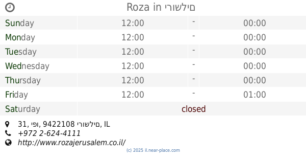
Roza
מתחם פיינגולד, יפו 31, ירושלים
Restaurant
read more
969 m
צ'ילי פיצריה
הלל 28, ירושלים
Restaurant
read more
969 m
Shulhan Hasultan
Yermiyahu Street 17, Jerusalem
Restaurant
read more
983 m
גורמה Gourmet
Yosef Rivlin Street 18, Jerusalem
Restaurant
read more
991 m
פיש בייט
שמגר 16, ירושלים
Restaurant
read more
1.016 km
Rony's Pizza
Jaffa Street 25, Jerusalem
Restaurant
read more
1.047 km
מוטי'ס
Shamgar Street 21, Jerusalem
Restaurant
read more
1.052 km
Walia Ibex
ירושלים
Restaurant
read more
1.107 km
DIANA'S B & B
10 Hulda HaNeviah Street, Musrara, POB 4030, 91040 Jerusalem, Jerusalem
Restaurant
read more
📑
all categories
Accounting
Administrative area level 1
Administrative area level 2
Airport
Amusement park
Aquarium
Art gallery
Atm
Bakery
Bank
Bar
Beauty salon
Bicycle store
Book store
Bowling alley
Bus station
Cafe
Campground
Car dealer
Car rental
Car repair
Car wash
Casino
Cemetery
Church
City hall
Clothing store
Colloquial area
Convenience store
Country
Courthouse
Dentist
Department store
Doctor
Electrician
Electronics store
Embassy
Establishment
Finance
Fire station
Florist
Food
Funeral home
Furniture store
Gas station
General contractor
Grocery or supermarket
Gym
Hair care
Hardware store
Health
Hindu Temple
Home goods store
Hospital
Insurance agency
Intersection
Jewelry store
Laundry
Lawyer
Library
Light rail station
Liquor store
Local government office
Locality
Locksmith
Lodging
Meal delivery
Meal takeaway
Mosque
Movie rental
Movie theater
Moving company
Museum
Natural feature
Neighborhood
Night club
Painter
Park
Parking
Pet store
Pharmacy
Physiotherapist
Place of worship
Plumber
Point of interest
Police
Political
Post office
Premise
Real estate agency
Restaurant
Roofing contractor
Route
Rv park, camping
School
Shoe store
Shopping mall
Spa
Stadium
Storage
Store
Subpremise
Subway station
Supermarket
Synagogue
Taxi stand
Train station
Transit station
Travel agency
University
Veterinary care
Zoo
administrative area level 3
administrative area level 4
sublocality level 1
↑