Restaurant nearby איסקנדר
Israel
Restaurant nearby איסקנדר
איסקנדר
גדות, Gadot, 12000
contacts phone
:
+972 4-900-7020
website:
iskander.rest.co.il
Latitude:
33.0251104
, Longitude:
35.6279082
larger map & directions
read more
nearest Restaurant
3.777 km
מסעדת בית העוגות
HaMezah, Yesud HaMa'ala
Restaurant
read more
3.991 km
פו בכיכר
Yesud, Yesud HaMa'ala
Restaurant
read more
4.912 km
אחוזת דוברובין גן אירועים ומסעדה
Yesud HaMa'ala
Restaurant
read more
7.151 km
El basha
Mahanayim Shopping Center, mahanayim shopping center
Restaurant
read more
7.818 km
פיצה ומאפיית הכפר
Unnamed Road, Tuba Zangariya
Bakery
Cafe
Restaurant
Point of interest
Store
Food
Establishment
read more
7.909 km
הטאגין
Hatzor HaGlilit
Restaurant
read more
8.001 km
חוות הג'ילבון
כביש 91
Restaurant
read more
9.62 km
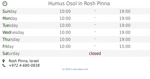
Humus Osol
Rosh Pinna
Restaurant
read more
9.78 km
דוני'ס
דרך המרכז, ראש פינה
Restaurant
read more
10.03 km
מסעדת ארגמן
עמוקה
Restaurant
read more
10.549 km
Papa Pizza
He-Khaluts Street 32, Rosh Pinna
Restaurant
read more
10.858 km
ג'חנון בגליל
11632, Kiryat Shmona
Restaurant
read more
11.547 km
מוסקט מסעדת מצפה הימים
צפת
Restaurant
read more
11.547 km
Muscat Restaurant Mizpe HaYamim
Safed
Restaurant
read more
12.525 km
קופי ענן
הר בנטל, צפת
Restaurant
read more
13.97 km
פריקסה זהבה
מגיני צפת, צפת
Restaurant
read more
14.001 km
שניצל בטעמים
ירושלים 89, צפת
Restaurant
read more
14.002 km
The falafel and shwarma
Jerusalem Street 84-86, Safed
Restaurant
read more
14.01 km
שווארמה
Jerusalem Street 88, Safed
Restaurant
Point of interest
Food
Establishment
read more
14.045 km
The Falafel Of Lalo
Jerusalem Street 76, Safed
Restaurant
read more
14.481 km
תאכזינה
Safed
Restaurant
read more
14.904 km
Restaurant Daboosh
אזור התעשיה החדש, Safed
Restaurant
read more
18.376 km
מסעדת הבוקרים - Habokrim Restaurant
מרום גולן
Restaurant
read more
18.376 km
Cowboys Restaurant
Merom Golan
Restaurant
read more
18.565 km
רומנטיקה במרום.romance bamarom
ארבל 76, Kahal
Lodging
Restaurant
Food
Point of interest
Establishment
read more
📑
all categories
Accounting
Administrative area level 1
Administrative area level 2
Airport
Amusement park
Aquarium
Art gallery
Atm
Bakery
Bank
Bar
Beauty salon
Bicycle store
Book store
Bowling alley
Bus station
Cafe
Campground
Car dealer
Car rental
Car repair
Car wash
Casino
Cemetery
Church
City hall
Clothing store
Colloquial area
Convenience store
Country
Courthouse
Dentist
Department store
Doctor
Electrician
Electronics store
Embassy
Establishment
Finance
Fire station
Florist
Food
Funeral home
Furniture store
Gas station
General contractor
Grocery or supermarket
Gym
Hair care
Hardware store
Health
Hindu Temple
Home goods store
Hospital
Insurance agency
Intersection
Jewelry store
Laundry
Lawyer
Library
Light rail station
Liquor store
Local government office
Locality
Locksmith
Lodging
Meal delivery
Meal takeaway
Mosque
Movie rental
Movie theater
Moving company
Museum
Natural feature
Neighborhood
Night club
Painter
Park
Parking
Pet store
Pharmacy
Physiotherapist
Place of worship
Plumber
Point of interest
Police
Political
Post office
Premise
Real estate agency
Restaurant
Roofing contractor
Route
Rv park, camping
School
Shoe store
Shopping mall
Spa
Stadium
Storage
Store
Subpremise
Subway station
Supermarket
Synagogue
Taxi stand
Train station
Transit station
Travel agency
University
Veterinary care
Zoo
administrative area level 3
administrative area level 4
sublocality level 1
↑