Restaurant nearby ירקות מאודים
Israel
Restaurant nearby ירקות מאודים
ירקות מאודים
Udim, Izrael
contacts phone
:
+972 52-537-3446
website:
www.facebook.com
Latitude:
32.2618962
, Longitude:
34.8458292
larger map & directions
read more
nearest Restaurant
541 m
Amigos
Harimon Street 1, Udim
Restaurant
read more
541 m
אמיגוס
הרימון 1, אודים
Restaurant
read more
751 m
קפה מוסקט
מתחם מוסקט, הדקל, אודים
Restaurant
read more
827 m
HaTaverna
Ha-Shita Street, Udim
Restaurant
read more
827 m
הטברנה
השיטה, אודים
Restaurant
read more
1.473 km
Макдоналдс
זלמן שזר 10, נתניה
Restaurant
read more
1.473 km
מקדונלד'ס
זלמן שזר 10, נתניה
Restaurant
read more
1.692 km
במבו וילג'
חוף פולג, נתניה
Restaurant
read more
1.728 km
Fiori
יקום
Restaurant
read more
1.846 km
קפה מקיאטו
בני ברמן 6, נתניה
Restaurant
read more
1.862 km
פיצה פרגו נתניה
בני ברמן 2, נתניה
Restaurant
read more
1.862 km
Пицца Фарго
Beni Berman Street 2, Netanya
Restaurant
read more
1.91 km
קפה גרג
בני ברמן 2, נתניה
Restaurant
read more
1.949 km
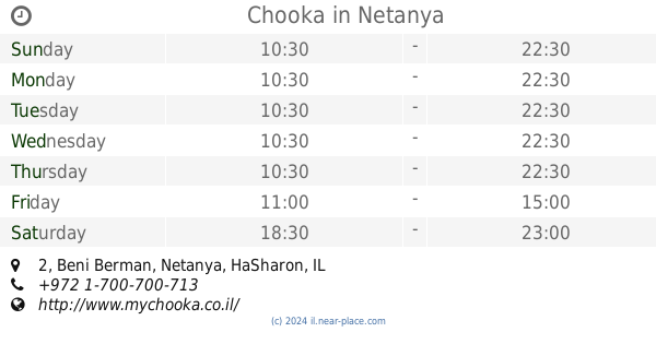
Chooka
קניון עיר ימים, Beni Berman 2, Netanya
Meal delivery
Meal takeaway
Restaurant
Food
Point of interest
Establishment
read more
1.953 km
McDonald's
קניון עיר ימים, בני ברמן 2, נתניה
Restaurant
read more
1.981 km
נגיסה
Maffi Street 5, Netanya
Restaurant
read more
2.058 km
ביגה - BIGA - מטבח בייקרי קפה
Netanya
Restaurant
read more
2.066 km
Suduch
Sderot Giborei Israel 5, Netanya
Restaurant
read more
2.13 km
McDonald's - מקדונלד'ס - סיטי פולג
שדרות גיבורי ישראל 5, נתניה
Restaurant
read more
2.23 km
Japanika Netanya
Sderot Giborei Israel 5, Netanya
Meal takeaway
Restaurant
Food
Point of interest
Establishment
read more
2.251 km
שווארמה הנביאים - עיוני
Ha-Omanut Street 8, Netanya
Restaurant
read more
2.286 km
Kitchen Bar
גיבורי ישראל 7, Netanya
Restaurant
read more
2.362 km
Jacko
בניין בית אדר, שדרות גיבורי ישראל 7, נתניה
Restaurant
read more
2.362 km
Жако
בניין בית אדר, שדרות גיבורי ישראל 7, נתניה
Restaurant
read more
2.415 km
עוזי חומוס פול
Sderot Giborei Israel 20, Netanya
Restaurant
read more
📑
all categories
Accounting
Administrative area level 1
Administrative area level 2
Airport
Amusement park
Aquarium
Art gallery
Atm
Bakery
Bank
Bar
Beauty salon
Bicycle store
Book store
Bowling alley
Bus station
Cafe
Campground
Car dealer
Car rental
Car repair
Car wash
Casino
Cemetery
Church
City hall
Clothing store
Colloquial area
Convenience store
Country
Courthouse
Dentist
Department store
Doctor
Electrician
Electronics store
Embassy
Establishment
Finance
Fire station
Florist
Food
Funeral home
Furniture store
Gas station
General contractor
Grocery or supermarket
Gym
Hair care
Hardware store
Health
Hindu Temple
Home goods store
Hospital
Insurance agency
Intersection
Jewelry store
Laundry
Lawyer
Library
Light rail station
Liquor store
Local government office
Locality
Locksmith
Lodging
Meal delivery
Meal takeaway
Mosque
Movie rental
Movie theater
Moving company
Museum
Natural feature
Neighborhood
Night club
Painter
Park
Parking
Pet store
Pharmacy
Physiotherapist
Place of worship
Plumber
Point of interest
Police
Political
Post office
Premise
Real estate agency
Restaurant
Roofing contractor
Route
Rv park, camping
School
Shoe store
Shopping mall
Spa
Stadium
Storage
Store
Subpremise
Subway station
Supermarket
Synagogue
Taxi stand
Train station
Transit station
Travel agency
University
Veterinary care
Zoo
administrative area level 3
administrative area level 4
sublocality level 1
↑