Restaurant nearby Water Restaurant
Israel
Restaurant nearby Water Restaurant
Water Restaurant
Sha'ab, Israel
contacts phone
:
+972
Latitude:
32.9018202
, Longitude:
35.2146155
larger map & directions
read more
nearest Restaurant
2.172 km
אצל גילי ותמר שולחן שף
Shahamon Street, Gilon
Restaurant
read more
2.59 km
Indiana Bar and Grill
כביש 85 כרמיאל-עכו (מתחם מנטה יער אחיהוד
Bar
Restaurant
Point of interest
Food
Establishment
read more
2.658 km
אינדיאנה גריל בר
מג'ד אל-כרום
Restaurant
read more
2.658 km
Indiana Bar and Grill
Majd al-Krum
Restaurant
read more
3.036 km
مطعم ومقهى هوى الوديان הווא אלודיאן
מג'ד אל-כרום
Restaurant
read more
3.262 km
חומוס אבו ראני
מג'ד אל-כרום
Restaurant
read more
3.262 km
Hummus Abu Rani
Majd al-Krum
Restaurant
read more
3.429 km
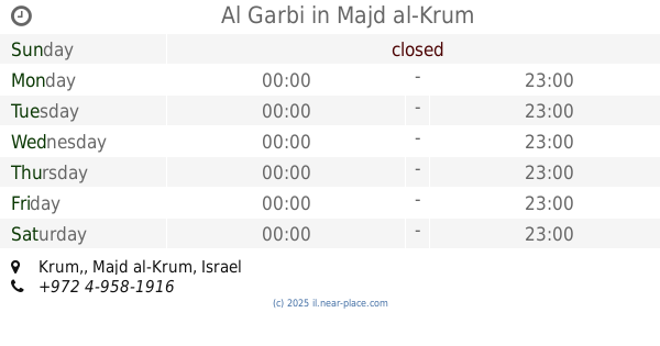
אל גרבי
Krum,, Majd al-Krum
Restaurant
read more
3.429 km
Al Garbi
Krum,, Majd al-Krum
Restaurant
read more
3.643 km
כפר נופש סאנדיבאד
כאבול
Restaurant
read more
3.719 km
Beit dolev
Tzurit, Zurit
Restaurant
read more
3.744 km
בית דולב
Tzurit
Restaurant
read more
3.744 km
בית דולב
צורית
Restaurant
read more
3.797 km
מפגש הטעם
Majd al-Krum
Restaurant
read more
3.874 km
קבב הכפר
Majd al-Krum
Restaurant
read more
4.403 km
שווארמה סרחאן
Majd al-Krum
Restaurant
read more
4.743 km
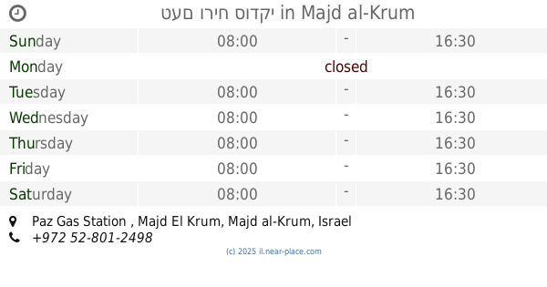
טעם וריח סודקי
Paz Gas Station , Majd El Krum
Restaurant
read more
6.3 km
מסעדת אבו עלי
Tamra
Restaurant
read more
6.353 km
בית הפנקיק המקורי
8533 503, Julis
Restaurant
read more
6.391 km
שוארמה אלחיר
מסעף טמרה, טמרה
Restaurant
read more
6.409 km
סמבוסאק סלאם
8533, Yarka
Restaurant
read more
6.419 km
מסעדת טעם של פעם
8533 503, Julis
Restaurant
read more
6.517 km
Alrobian
דור אלון, כביש 784
Restaurant
read more
6.569 km
פיצה מטיילת
Unnamed Road, Rakefet
Restaurant
read more
6.608 km
באלה חומוס
לב משגב, 2017500, Rakefet
Restaurant
read more
📑
all categories
Accounting
Administrative area level 1
Administrative area level 2
Airport
Amusement park
Aquarium
Art gallery
Atm
Bakery
Bank
Bar
Beauty salon
Bicycle store
Book store
Bowling alley
Bus station
Cafe
Campground
Car dealer
Car rental
Car repair
Car wash
Casino
Cemetery
Church
City hall
Clothing store
Colloquial area
Convenience store
Country
Courthouse
Dentist
Department store
Doctor
Electrician
Electronics store
Embassy
Establishment
Finance
Fire station
Florist
Food
Funeral home
Furniture store
Gas station
General contractor
Grocery or supermarket
Gym
Hair care
Hardware store
Health
Hindu Temple
Home goods store
Hospital
Insurance agency
Intersection
Jewelry store
Laundry
Lawyer
Library
Light rail station
Liquor store
Local government office
Locality
Locksmith
Lodging
Meal delivery
Meal takeaway
Mosque
Movie rental
Movie theater
Moving company
Museum
Natural feature
Neighborhood
Night club
Painter
Park
Parking
Pet store
Pharmacy
Physiotherapist
Place of worship
Plumber
Point of interest
Police
Political
Post office
Premise
Real estate agency
Restaurant
Roofing contractor
Route
Rv park, camping
School
Shoe store
Shopping mall
Spa
Stadium
Storage
Store
Subpremise
Subway station
Supermarket
Synagogue
Taxi stand
Train station
Transit station
Travel agency
University
Veterinary care
Zoo
administrative area level 3
administrative area level 4
sublocality level 1
↑