Restaurant nearby טאטי
Israel
Restaurant nearby טאטי
טאטי
3, Avraham Giron Street, Yehud, Petach Tikva, IL Israel
contacts phone
:
+972 53-936-6104
website:
www.tatti.co.il
Latitude:
32.0272976
, Longitude:
34.8948473
larger map & directions
read more
nearest Restaurant
7 m
Tatti Loft Yehud
Avraham Giron Street 3, Yehud-Monosson
Restaurant
Food
Point of interest
Establishment
read more
82 m
שווארמה האחים
Shabazi Street 10, Yehud
Restaurant
read more
188 m
דונר/שווארמה טורקית ועל האש
אברהם גירון 20, יהוד
Restaurant
read more
194 m
דונר שאוורמה טורקית אוריגינלית
אברהם גירון 26, יהוד
Restaurant
read more
220 m
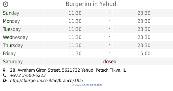
Burgerim
Avraham Giron Street 28, Yehud
Restaurant
read more
220 m
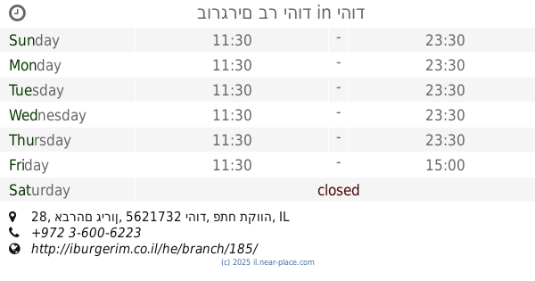
בורגרים בר יהוד
אברהם גירון 28, יהוד
Restaurant
read more
285 m
בואנו מסעדה איטלקית כשרה למהדרין
בית השחף, מוהליבר 2 ב, יהוד
Restaurant
read more
365 m
מתוק מהלב
Derech HaAtsma'ut 54, Yehud
Restaurant
read more
380 m
פאצו קוזין
Altalef Street 3, Yehud
Restaurant
read more
388 m
Zinc
Altalef Street 5, Yehud
Restaurant
read more
415 m
Ashkenazi Humus
Ashkenazi Street 19, Yehud
Restaurant
read more
416 m
פונדק אקספרס - מזללת קבב
אלטלף 2, יהוד
Restaurant
read more
596 m
Humus Givataim
HaTa'asiya Street 16, Or Yehuda
Restaurant
read more
609 m
Roket
Derech HaAtsma'ut 34, Yehud
Restaurant
read more
609 m
רוקט
דרך העצמאות 34, יהוד
Restaurant
read more
677 m
עגלקטיקוס
Se'adya Khatuka Street 18, Yehud
Restaurant
read more
724 m
פלאפל ציון 2
Tsvi Yishai Street 14, Yehud
Restaurant
read more
805 m
Dr. Mitt
Tsvi Yishai Street 5, Yehud
Restaurant
read more
818 m
מפגש L.A
אלפרט 11, יהוד
Restaurant
read more
836 m
B2
בית ישי, דרך העצמאות 16, יהוד
Restaurant
read more
837 m
Big Burger
Tsvi Yishai Street 1, Yehud
Restaurant
read more
837 m
ביג בורגר
צבי ישי 1, יהוד
Restaurant
read more
914 m
White corner Ltd.
Herzl Street 7, Yehud
Restaurant
read more
935 m
אסתר
דרך העצמאות 8, יהוד
Restaurant
read more
935 m
אסתר
Derech HaAtsma'ut 8, Yehud
Restaurant
read more
📑
all categories
Accounting
Administrative area level 1
Administrative area level 2
Airport
Amusement park
Aquarium
Art gallery
Atm
Bakery
Bank
Bar
Beauty salon
Bicycle store
Book store
Bowling alley
Bus station
Cafe
Campground
Car dealer
Car rental
Car repair
Car wash
Casino
Cemetery
Church
City hall
Clothing store
Colloquial area
Convenience store
Country
Courthouse
Dentist
Department store
Doctor
Electrician
Electronics store
Embassy
Establishment
Finance
Fire station
Florist
Food
Funeral home
Furniture store
Gas station
General contractor
Grocery or supermarket
Gym
Hair care
Hardware store
Health
Hindu Temple
Home goods store
Hospital
Insurance agency
Intersection
Jewelry store
Laundry
Lawyer
Library
Light rail station
Liquor store
Local government office
Locality
Locksmith
Lodging
Meal delivery
Meal takeaway
Mosque
Movie rental
Movie theater
Moving company
Museum
Natural feature
Neighborhood
Night club
Painter
Park
Parking
Pet store
Pharmacy
Physiotherapist
Place of worship
Plumber
Point of interest
Police
Political
Post office
Premise
Real estate agency
Restaurant
Roofing contractor
Route
Rv park, camping
School
Shoe store
Shopping mall
Spa
Stadium
Storage
Store
Subpremise
Subway station
Supermarket
Synagogue
Taxi stand
Train station
Transit station
Travel agency
University
Veterinary care
Zoo
administrative area level 3
administrative area level 4
sublocality level 1
↑