Restaurant nearby אטליז ומסעדת אל ודיאן
Israel
Restaurant nearby אטליז ומסעדת אל ודיאן
אטליז ומסעדת אל ודיאן
ירכא, ישראל
contacts phone
:
+972 53-230-1008
Latitude:
32.9590918
, Longitude:
35.2173131
larger map & directions
read more
nearest Restaurant
612 m
The Special 1
ירכא
Restaurant
read more
612 m
The Special 1
Yarka
Restaurant
read more
792 m
Foodruse
Cnaan mall, Yarcha
Restaurant
read more
792 m
פודרוז
Cnaan mall, Yarcha
Restaurant
read more
794 m
Falafel Srks Yarka
Unnamed Road, Yarka
Restaurant
read more
796 m
שווארמה האלופים
יארכה, ירכא
Restaurant
read more
1.578 km
adama vegan guesthouse
מטה, אשר
Restaurant
read more
1.869 km
טאבון הכיכר
ירכא
Restaurant
read more
2.057 km
מסעדת מפגש החברים
Yanuh-Jat
Restaurant
read more
2.295 km
קיוסק באב אלחארה
Unnamed Road, יאנוח ג'ת
Restaurant
read more
2.431 km
המטבח של ג'נט
יאנוח ג'ת
Restaurant
read more
2.431 km
המטבח של ג'נט
Yanuh-Jat
Restaurant
read more
2.438 km
מרכז סרקס
8533, Yarka
Restaurant
read more
2.487 km
בורקס טורקי ירכא
ירכא
Restaurant
read more
2.509 km
שיפודי ג'נג'י
ירכא
Restaurant
read more
2.698 km
The Indian Israeli restaurant at Klil. Tammy&Shlomo
Unnamed Road Klil
Restaurant
read more
2.702 km
Cafe Klil
Klil
Restaurant
read more
2.857 km
פיצה פאלה ירכא
Yarka
Restaurant
read more
3.239 km
Clil In The Galilee
Clil P.O. Box oshrat, Yehiam
Restaurant
read more
4.088 km
Caf'e Mazaya مزايا
Yarka
Restaurant
read more
4.181 km
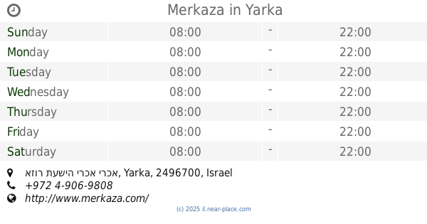
Merkaza
אזור תעשיה ירכא ירכא
Shopping mall
Supermarket
Grocery or supermarket
Restaurant
Food
Point of interest
Store
Establishment
read more
4.29 km
Druz Sweets Ala Saraia
Yarka
Restaurant
read more
4.331 km
בורגר מי
ירכא
Restaurant
read more
5.306 km
קבב הכפר
Majd al-Krum
Restaurant
read more
5.497 km
מסעדת דיוואן
דיר אל-אסד
Restaurant
read more
📑
all categories
Accounting
Administrative area level 1
Administrative area level 2
Airport
Amusement park
Aquarium
Art gallery
Atm
Bakery
Bank
Bar
Beauty salon
Bicycle store
Book store
Bowling alley
Bus station
Cafe
Campground
Car dealer
Car rental
Car repair
Car wash
Casino
Cemetery
Church
City hall
Clothing store
Colloquial area
Convenience store
Country
Courthouse
Dentist
Department store
Doctor
Electrician
Electronics store
Embassy
Establishment
Finance
Fire station
Florist
Food
Funeral home
Furniture store
Gas station
General contractor
Grocery or supermarket
Gym
Hair care
Hardware store
Health
Hindu Temple
Home goods store
Hospital
Insurance agency
Intersection
Jewelry store
Laundry
Lawyer
Library
Light rail station
Liquor store
Local government office
Locality
Locksmith
Lodging
Meal delivery
Meal takeaway
Mosque
Movie rental
Movie theater
Moving company
Museum
Natural feature
Neighborhood
Night club
Painter
Park
Parking
Pet store
Pharmacy
Physiotherapist
Place of worship
Plumber
Point of interest
Police
Political
Post office
Premise
Real estate agency
Restaurant
Roofing contractor
Route
Rv park, camping
School
Shoe store
Shopping mall
Spa
Stadium
Storage
Store
Subpremise
Subway station
Supermarket
Synagogue
Taxi stand
Train station
Transit station
Travel agency
University
Veterinary care
Zoo
administrative area level 3
administrative area level 4
sublocality level 1
↑