Restaurant nearby סייה מסעדה
Israel
Restaurant nearby סייה מסעדה
סייה מסעדה
שביל ישראל, הרצליה, IL ישראל
contacts phone
:
+972
Latitude:
32.1658091
, Longitude:
34.7982554
larger map & directions
read more
nearest Restaurant
229 m
בל ביץ'
חוף אכדיה, הרצליה
Restaurant
read more
237 m
Martiniq
Ha-Shunit Street 2, Herzliya
Restaurant
read more
274 m
פאפאגאיו ארנה
השונית 2, הרצליה
Restaurant
read more
274 m
Hummus +
השונית 2, הרצליה
Restaurant
read more
363 m
Meat and Eat
HaTsedef Street 15950, Herzliya
Restaurant
read more
477 m
מאקה מאקה
רמת ים 80, הרצליה
Restaurant
read more
521 m
בני הדייג מרינה הרצליה
יורדי ים 1, הרצליה
Restaurant
read more
828 m
כספי על הים By Nine Beach
Ramat Yam St 50 Herzliya IL 4685150, Ramat Yam Street 50, Herzliya
Restaurant
read more
828 m
ocean 50
Ramat Yam Street 50, Herzliya
Restaurant
read more
828 m
כספי על הים By Nine Beach
Ramat Yam St 50 Herzliya IL 4685150, רמת ים 50, הרצליה
Restaurant
read more
851 m
בנדיקט
האצ"ל 1, הרצליה
Restaurant
read more
875 m
MeatBar Restaurant
Ha-Sadna'ot Street 4, Herzliya
Restaurant
read more
912 m
גונדולה
שדרות אבא אבן 18, הרצליה
Restaurant
read more
924 m
Samsara
Galgalei ha-Plada Street 11, Herzliya
Restaurant
read more
1.045 km
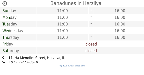
Bahadunes
Ha-Menofim Street 11, Herzliya
Restaurant
read more
1.062 km
ויקטור'ס
המנופים 8, הרצליה
Restaurant
read more
1.063 km
Giraffe
Ha-Manofim 9, הרצליה
Restaurant
read more
1.068 km
Chicken Box
Abba Eban Boulevard 12, Herzliya
Restaurant
read more
1.07 km
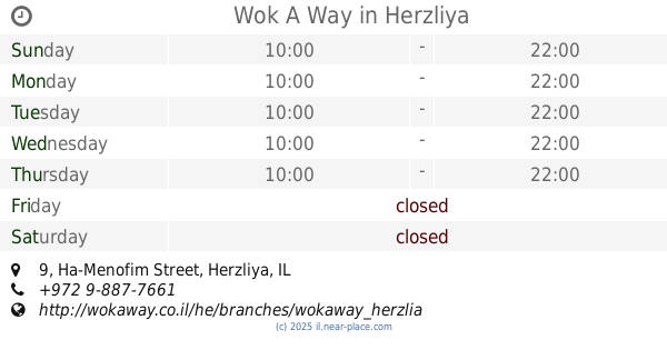
Wok A Way
Ha-Menofim Street 9, Herzliya
Restaurant
read more
1.085 km
Davidi
Abba Eban Boulevard 12, Herzliya
Restaurant
read more
1.085 km
Minato
Ha-Menofim Street 8, Herzliya
Restaurant
read more
1.219 km
ברגר קינג
אריה שנקר 14, הרצליה
Restaurant
read more
1.233 km
#SegevArt Herzliya
Arieh Shenkar Street 16, Herzliya
Restaurant
read more
1.256 km
Montagy
16 Arie shenkar St, Herzliya Pituah
Restaurant
read more
1.26 km
בורגוס בורגר בר
אריה שנקר 11, הרצליה
Restaurant
read more
📑
all categories
Accounting
Administrative area level 1
Administrative area level 2
Airport
Amusement park
Aquarium
Art gallery
Atm
Bakery
Bank
Bar
Beauty salon
Bicycle store
Book store
Bowling alley
Bus station
Cafe
Campground
Car dealer
Car rental
Car repair
Car wash
Casino
Cemetery
Church
City hall
Clothing store
Colloquial area
Convenience store
Country
Courthouse
Dentist
Department store
Doctor
Electrician
Electronics store
Embassy
Establishment
Finance
Fire station
Florist
Food
Funeral home
Furniture store
Gas station
General contractor
Grocery or supermarket
Gym
Hair care
Hardware store
Health
Hindu Temple
Home goods store
Hospital
Insurance agency
Intersection
Jewelry store
Laundry
Lawyer
Library
Light rail station
Liquor store
Local government office
Locality
Locksmith
Lodging
Meal delivery
Meal takeaway
Mosque
Movie rental
Movie theater
Moving company
Museum
Natural feature
Neighborhood
Night club
Painter
Park
Parking
Pet store
Pharmacy
Physiotherapist
Place of worship
Plumber
Point of interest
Police
Political
Post office
Premise
Real estate agency
Restaurant
Roofing contractor
Route
Rv park, camping
School
Shoe store
Shopping mall
Spa
Stadium
Storage
Store
Subpremise
Subway station
Supermarket
Synagogue
Taxi stand
Train station
Transit station
Travel agency
University
Veterinary care
Zoo
administrative area level 3
administrative area level 4
sublocality level 1
↑