Restaurant nearby שווארמה ראמי טבעוני
Israel
Restaurant nearby שווארמה ראמי טבעוני
שווארמה ראמי טבעוני
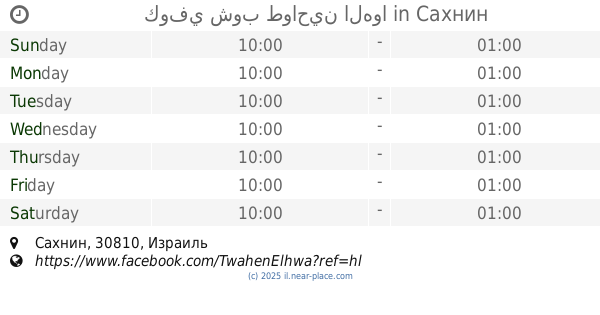
Сахнин, Израиль
contacts phone
:
+972
Latitude:
32.8607129
, Longitude:
35.3048889
larger map & directions
read more
nearest Restaurant
109 m
חומוס מיכא
Sakhnin
Restaurant
read more
166 m
كوفي شوب طواحين الهوا
Sakhnin
Restaurant
read more
228 m
קנדטוריה פיפתי
805, סח'נין
Restaurant
read more
228 m
קנדטוריה פיפתי
805, Sakhnin
Restaurant
read more
346 m
פיצה בראוו
סכנין כביש ראשי, סח'נין
Restaurant
read more
346 m
פיצה בראוו
סכנין כביש ראשי, Sakhnin
Restaurant
read more
487 m
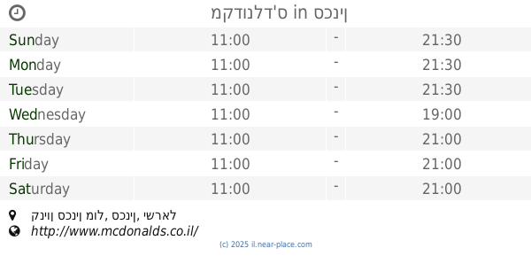
McDonald's
קניון סכנין מול, סכנין
Restaurant
read more
487 m
Макдоналдс
קניון סכנין מול, סכנין
Restaurant
read more
487 m
מקדונלד'ס
קניון סכנין מול, סכנין
Restaurant
read more
538 m
La Dolce Vita Gelato
כיכר ראשי 49, Sakhnin
Cafe
Store
Restaurant
Food
Point of interest
Establishment
read more
546 m
מיסטר שווארמה
Sakhnin
Restaurant
read more
616 m
مطعم دبي سخنين
805, סח'נין
Restaurant
read more
719 m
חומוס מדמס
סח'נין
Restaurant
read more
766 m
מסעדת אבו שאדי
סח'נין
Restaurant
read more
766 m
מסעדת אבו שאדי
Sakhnin
Restaurant
read more
777 m
Abu Shadi hummus restaurant
Sakhnin
Restaurant
Food
Point of interest
Establishment
read more
786 m
Maxicana sakhnin - مكسيكانا سخنين
V76W+WM4, Sakhnin
Restaurant
Food
Point of interest
Establishment
read more
934 m
שוארמה אסטנבול
805, סח'נין
Restaurant
read more
934 m
שוארמה אסטנבול
805, Sakhnin
Restaurant
read more
937 m
Savoy restaurant - מסעדת סבוי
Sakhnin
Restaurant
Food
Point of interest
Establishment
read more
942 m
ميسجاف
Sakhnin
Restaurant
read more
1.025 km
Doha Najma
Sakhnin
Restaurant
read more
1.039 km
שיפודייה בשכונה - בהנהלת פיראס גאליה
سخنين،
Restaurant
read more
1.039 km
Entricot
Sakhnin
Restaurant
read more
1.07 km
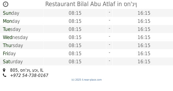
Restaurant Bilal Abu Atlaf
805, סח'נין
Restaurant
read more
📑
all categories
Accounting
Administrative area level 1
Administrative area level 2
Airport
Amusement park
Aquarium
Art gallery
Atm
Bakery
Bank
Bar
Beauty salon
Bicycle store
Book store
Bowling alley
Bus station
Cafe
Campground
Car dealer
Car rental
Car repair
Car wash
Casino
Cemetery
Church
City hall
Clothing store
Colloquial area
Convenience store
Country
Courthouse
Dentist
Department store
Doctor
Electrician
Electronics store
Embassy
Establishment
Finance
Fire station
Florist
Food
Funeral home
Furniture store
Gas station
General contractor
Grocery or supermarket
Gym
Hair care
Hardware store
Health
Hindu Temple
Home goods store
Hospital
Insurance agency
Intersection
Jewelry store
Laundry
Lawyer
Library
Light rail station
Liquor store
Local government office
Locality
Locksmith
Lodging
Meal delivery
Meal takeaway
Mosque
Movie rental
Movie theater
Moving company
Museum
Natural feature
Neighborhood
Night club
Painter
Park
Parking
Pet store
Pharmacy
Physiotherapist
Place of worship
Plumber
Point of interest
Police
Political
Post office
Premise
Real estate agency
Restaurant
Roofing contractor
Route
Rv park, camping
School
Shoe store
Shopping mall
Spa
Stadium
Storage
Store
Subpremise
Subway station
Supermarket
Synagogue
Taxi stand
Train station
Transit station
Travel agency
University
Veterinary care
Zoo
administrative area level 3
administrative area level 4
sublocality level 1
↑