Restaurant nearby רוזמרין
Israel
Restaurant nearby רוזמרין
רוזמרין
19-27, Efron Street, Haifa, Haifa, IL Israel
contacts phone
:
+972
website:
www.yagurgan.co.il
Latitude:
32.8331563
, Longitude:
34.9853678
larger map & directions
read more
nearest Restaurant
1 m
הסושיה
עפרון 9-17, חיפה
Restaurant
read more
1 m
הסושיה
Efron Street 9-17, Haifa
Restaurant
read more
167 m
מסעדת חברים
HaAliya HaShniya Street 2, Haifa
Restaurant
read more
188 m
קבב שווארמה
העלייה השנייה 0, חיפה
Restaurant
read more
376 m
מסעדת הפקולטה
Haifa
Restaurant
read more
388 m
יעקב קבב
העלייה השנייה 20, חיפה
Restaurant
read more
388 m
Falafel brother
HaAliya HaShniya Street 20, Haifa
Restaurant
read more
477 m
Viktor's Sandwich
HaSharon Street 10, Haifa
Restaurant
read more
480 m
פיצה מוריני
42,, HaAliya HaShniya Street 38, Haifa
Restaurant
read more
492 m
ויקטור סנדוויצים
15, HaSharon Street 9, Haifa
Restaurant
read more
509 m
כריכי ויקטור
השרון 12, חיפה
Restaurant
read more
642 m
מסעדת אבו יוסף
A.L. Ziso Street 29, Haifa
Restaurant
read more
642 m
מסעדת אבו יוסף
א.ל. זיסו 29, חיפה
Restaurant
read more
692 m
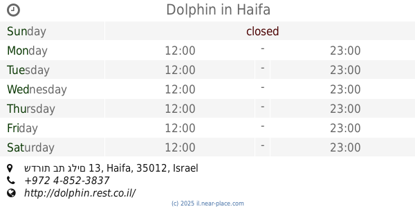
Dolphin
שדרות בת גלים 13, Haifa
Restaurant
read more
703 m
שווארמה חאזן
Jaffa Road 140, Haifa
Restaurant
read more
712 m
Shawarma Hazen
Jaffa Road 136, Haifa
Restaurant
read more
743 m
Shawarma brothers
Jaffa Road 136, Haifa
Restaurant
read more
744 m
קפה סקואלה
תל אביב 46, חיפה
Restaurant
read more
744 m
Yoheved
Tel Aviv Street 46, Haifa
Restaurant
read more
759 m
שווארמה ג'יבלי
שד' ההסתדרות 84, חיפה
Restaurant
read more
761 m
Jibli
Jaffa Road 134, Haifa
Restaurant
read more
805 m
מיסדג
Retsif Pinhas Margolin Street, Haifa
Restaurant
read more
902 m
קינג ג'ורג' פיצה
Tel Aviv Street 16, Haifa
Restaurant
read more
1.056 km
מסעדת האם נבילה
Tel Aviv Street 1, Haifa
Restaurant
read more
1.056 km
מסעדת האם נבילה
תל אביב 1, חיפה
Restaurant
read more
📑
all categories
Accounting
Administrative area level 1
Administrative area level 2
Airport
Amusement park
Aquarium
Art gallery
Atm
Bakery
Bank
Bar
Beauty salon
Bicycle store
Book store
Bowling alley
Bus station
Cafe
Campground
Car dealer
Car rental
Car repair
Car wash
Casino
Cemetery
Church
City hall
Clothing store
Colloquial area
Convenience store
Country
Courthouse
Dentist
Department store
Doctor
Electrician
Electronics store
Embassy
Establishment
Finance
Fire station
Florist
Food
Funeral home
Furniture store
Gas station
General contractor
Grocery or supermarket
Gym
Hair care
Hardware store
Health
Hindu Temple
Home goods store
Hospital
Insurance agency
Intersection
Jewelry store
Laundry
Lawyer
Library
Light rail station
Liquor store
Local government office
Locality
Locksmith
Lodging
Meal delivery
Meal takeaway
Mosque
Movie rental
Movie theater
Moving company
Museum
Natural feature
Neighborhood
Night club
Painter
Park
Parking
Pet store
Pharmacy
Physiotherapist
Place of worship
Plumber
Point of interest
Police
Political
Post office
Premise
Real estate agency
Restaurant
Roofing contractor
Route
Rv park, camping
School
Shoe store
Shopping mall
Spa
Stadium
Storage
Store
Subpremise
Subway station
Supermarket
Synagogue
Taxi stand
Train station
Transit station
Travel agency
University
Veterinary care
Zoo
administrative area level 3
administrative area level 4
sublocality level 1
↑