Restaurant nearby Roladin
Israel
Restaurant nearby Roladin
Roladin
19, תרצה, רמת גן, IL ישראל
contacts phone
:
+972
Latitude:
32.0716069
, Longitude:
34.8287949
larger map & directions
read more
nearest Restaurant
16 m
Café Café
מרכז מרום נווה, תרצה 19, רמת גן
Cafe
Restaurant
Food
Point of interest
Store
Establishment
read more
34 m
אושי אושי
Khayim Landau Street 7, Ramat Gan
Restaurant
read more
38 m
Burgeranch
חיים לנדאו 7A, רמת גן
Restaurant
read more
52 m
מן בורגר
Tirzah Street 19, Ramat Gan
Restaurant
read more
52 m
מן בורגר
תרצה 19, רמת גן
Restaurant
read more
260 m
שניצל ציון
Derech Negba 39, Ramat Gan
Restaurant
read more
314 m
המטבח של טל
Pinkas Street 6, Ramat Gan
Restaurant
read more
329 m
Santa Katerina
2, Har Sinai Street, Tel Aviv-Yafo
Restaurant
read more
424 m
אייס פוינט רמת גן
הרא"ה 186, רמת גן
Restaurant
read more
446 m
חומוס ירושלים
Sderot Yerushalayim 54, Ramat Gan
Restaurant
read more
472 m
Friedman authentic Jewish food
Derech Negba 15, Ramat Gan
Restaurant
read more
549 m
ג'חנון לשבת
Uzi'el Street 70, Ramat Gan
Restaurant
read more
584 m
Tommy roll bar
Sderot Yerushalayim 42, Ramat Gan
Restaurant
read more
633 m
חומוס גבעתיים
עוזיאל 97, רמת גן
Restaurant
read more
633 m
חומוס גבעתיים
Uzi'el Street 97, Ramat Gan
Restaurant
read more
702 m
חומוס בויה
Rosh Pina Street 9, Ramat Gan
Restaurant
read more
765 m
פלאפל מנה מנה
Sderot Yerushalayim 26, Ramat Gan
Restaurant
read more
793 m
Spicy Grill Bar
Ha-roeh, Haroe Street 133, Ramat Gan
Restaurant
read more
859 m
פקוס
אצ"ל 46, רמת גן
Restaurant
read more
914 m
פלאפל
אמרי חיים 32, בני ברק
Restaurant
read more
1.001 km
פיצוחי ידעי
קהילות יעקב 37, בני ברק
Restaurant
read more
1.001 km
Fitzohi Idai
Kehilot Ya'akov Street 37, Bnei Brak
Restaurant
read more
1.026 km
שיפודי סמי ובניו
דרך בן גוריון 173, רמת גן
Restaurant
read more
1.026 km
שיפודי סמי ובניו
Derech Ben Gurion 173, Ramat Gan
Restaurant
read more
1.246 km
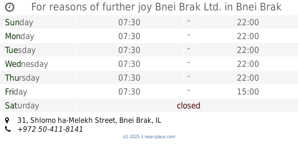
For reasons of further joy Bnei Brak Ltd.
Shlomo ha-Melekh Street 31, Bnei Brak
Restaurant
read more
📑
all categories
Accounting
Administrative area level 1
Administrative area level 2
Airport
Amusement park
Aquarium
Art gallery
Atm
Bakery
Bank
Bar
Beauty salon
Bicycle store
Book store
Bowling alley
Bus station
Cafe
Campground
Car dealer
Car rental
Car repair
Car wash
Casino
Cemetery
Church
City hall
Clothing store
Colloquial area
Convenience store
Country
Courthouse
Dentist
Department store
Doctor
Electrician
Electronics store
Embassy
Establishment
Finance
Fire station
Florist
Food
Funeral home
Furniture store
Gas station
General contractor
Grocery or supermarket
Gym
Hair care
Hardware store
Health
Hindu Temple
Home goods store
Hospital
Insurance agency
Intersection
Jewelry store
Laundry
Lawyer
Library
Light rail station
Liquor store
Local government office
Locality
Locksmith
Lodging
Meal delivery
Meal takeaway
Mosque
Movie rental
Movie theater
Moving company
Museum
Natural feature
Neighborhood
Night club
Painter
Park
Parking
Pet store
Pharmacy
Physiotherapist
Place of worship
Plumber
Point of interest
Police
Political
Post office
Premise
Real estate agency
Restaurant
Roofing contractor
Route
Rv park, camping
School
Shoe store
Shopping mall
Spa
Stadium
Storage
Store
Subpremise
Subway station
Supermarket
Synagogue
Taxi stand
Train station
Transit station
Travel agency
University
Veterinary care
Zoo
administrative area level 3
administrative area level 4
sublocality level 1
↑