Restaurant nearby Restaurant El-Wadi
Israel
Restaurant nearby Restaurant El-Wadi
Restaurant El-Wadi
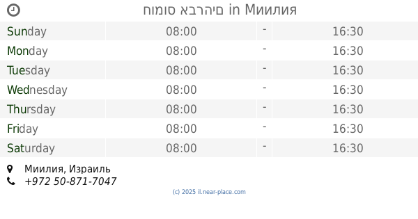
Montfort road, 2514000, Mi'ilya, Akko, IL Israel
contacts phone
:
+972 4-957-3904
website:
allwadi.rest.co.il
Latitude:
33.0298934
, Longitude:
35.2530641
larger map & directions
read more
nearest Restaurant
406 m
El Vadi
Mi'ilya
Restaurant
read more
406 m
אל וואדי
מעיליא
Restaurant
read more
414 m
מסעדת המנגל והשיפוד
מעיליה
Restaurant
read more
426 m
HaMangal, המנגל והשיפוד
מעליא ,כביש בי"ס נוטרדאם, Mi'ilya
Restaurant
read more
469 m
Restaurant grill and skewer
מעיליה בכניסה לכפר
Restaurant
read more
535 m
מסעדת אלרביע
Ma'alia
Restaurant
read more
539 m
מנצ'יס גריל בר
מעיליא
Restaurant
read more
553 m
פלאפל עווד מעיליא - Falafel Awad Mi'ilya
Miliya main street, Miliya
Restaurant
read more
553 m
קפה קפה
מעיליא
Restaurant
read more
553 m
Coffee Coffee
Mi'ilya
Restaurant
read more
553 m
Coffee Coffee
מעיליא
Restaurant
read more
899 m
Boaz Mevashel
Mitzpe Hila
Restaurant
read more
1.125 km
העזבה של אליאס
מעיליא
Restaurant
read more
1.125 km
העזבה של אליאס
Mi'ilya
Restaurant
read more
1.317 km
מסעדת חנאן
מעלות תרשיחא
Restaurant
read more
1.319 km
HANAN Restaurant מסעדת חנאן مطعم حنان
Mi'ilya
Restaurant
read more
1.339 km
חומוס אברהים
Mi'ilya
Restaurant
read more
1.839 km
Maroush Restaurant - מסעדת מרוש
Israel
Restaurant
read more
2.186 km
Delicat
בניין סאראיא, רח השוק 1, מעלות תרשיחא
Restaurant
read more
2.235 km
אמה - אוכל רומני
מעלות תרשיחא
Restaurant
read more
2.273 km
פלאפל יוסף וכנאפה גימי
HaShuk Street 6-12, Ma'alot-Tarshiha
Restaurant
read more
2.273 km
פלאפל יוסף וכנאפה גימי
השוק 6-12, מעלות תרשיחא
Restaurant
read more
2.286 km
ארט ברגר
Ma'ale HaMisgad Street, Ma'alot-Tarshiha
Restaurant
read more
2.335 km
פלאפל יוסף
השוק, מעלות תרשיחא
Restaurant
read more
2.426 km
Restaurant Transylvania
ליד חוות הסוסים, Ma'alot-Tarshiha
Restaurant
read more
📑
all categories
Accounting
Administrative area level 1
Administrative area level 2
Airport
Amusement park
Aquarium
Art gallery
Atm
Bakery
Bank
Bar
Beauty salon
Bicycle store
Book store
Bowling alley
Bus station
Cafe
Campground
Car dealer
Car rental
Car repair
Car wash
Casino
Cemetery
Church
City hall
Clothing store
Colloquial area
Convenience store
Country
Courthouse
Dentist
Department store
Doctor
Electrician
Electronics store
Embassy
Establishment
Finance
Fire station
Florist
Food
Funeral home
Furniture store
Gas station
General contractor
Grocery or supermarket
Gym
Hair care
Hardware store
Health
Hindu Temple
Home goods store
Hospital
Insurance agency
Intersection
Jewelry store
Laundry
Lawyer
Library
Light rail station
Liquor store
Local government office
Locality
Locksmith
Lodging
Meal delivery
Meal takeaway
Mosque
Movie rental
Movie theater
Moving company
Museum
Natural feature
Neighborhood
Night club
Painter
Park
Parking
Pet store
Pharmacy
Physiotherapist
Place of worship
Plumber
Point of interest
Police
Political
Post office
Premise
Real estate agency
Restaurant
Roofing contractor
Route
Rv park, camping
School
Shoe store
Shopping mall
Spa
Stadium
Storage
Store
Subpremise
Subway station
Supermarket
Synagogue
Taxi stand
Train station
Transit station
Travel agency
University
Veterinary care
Zoo
administrative area level 3
administrative area level 4
sublocality level 1
↑