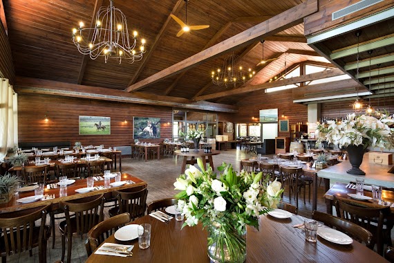
Restaurant nearby קיי-בר
Israel
Restaurant nearby קיי-בר
קיי-בר
צומת אמיר (ווסט) רמת הגולן, רמת הגולן
contacts phone
:
+972 4-877-3977
Latitude:
33.1359989
, Longitude:
35.7327178
larger map & directions
read more
nearest Restaurant
7 m
קיי בורגר אקספרס - K burger express
צומת ווסט (אמיר) רמת הגולן, קיבוץ להבות הבשן ד.נ. גליל עליון
Restaurant
read more
2.486 km
אצל צ'בי
Shaal
Restaurant
read more
2.486 km
Chebis
Shaal
Restaurant
read more
2.584 km
אמירוס - פשוט טעים
1, שעל
Restaurant
read more
4.02 km
הטובים של שפרה
Merom Golan
Restaurant
read more
4.401 km
מסעדת הבוקרים - Habokrim Restaurant
מרום גולן
Restaurant
read more
4.401 km
Cowboys Restaurant
Merom Golan
Restaurant
read more
4.401 km
The Cowboy Restaurant (HaBokrim)
Merom Golan
Restaurant
read more
4.536 km
השף היושב
מצוק עורבים 90 קלע
Restaurant
read more
9.41 km
אחוזת הכרמים
Israel
Restaurant
read more
9.93 km
חוות הג'ילבון
כביש 91
Restaurant
read more
10.5 km
בית הסמבוםק
כביש 98, מסדה
Restaurant
read more
11.561 km
מסעדת הוואנה ווילג'
חניון ברכת רם, Mas'ada
Restaurant
read more
12.304 km
Dining Room Kfar Blum
Kfar Blum
Restaurant
read more
13.331 km
פיש 99
Emek Hulah
Restaurant
read more
14.598 km
Klompus
מתחם דור אלון, כביש 99, הגושרים
Restaurant
read more
14.606 km
Why? Restaurant Cafe
Majdal Shams
Restaurant
read more
14.689 km
McDonald's
HaZikaron Garden, Ma'ayan Baruch
Restaurant
read more
15.099 km
ג'חנון בגליל
11632, Kiryat Shmona
Restaurant
read more
16.036 km
בורגרים קרית שמונה
Qiryat Shemona
Restaurant
read more
16.172 km
שיפודי רון
הפלדה 14, קרית שמונה
Restaurant
read more
17.578 km
השניצליה
90 8, קרית שמונה
Restaurant
read more
17.623 km
הגינה של לייבה
Tel Hai Street 277, Qiryat Shemona
Restaurant
read more
18.902 km
חומוס באצבע
Unnamed Road, Kfar Giladi
Restaurant
read more
20.582 km
Водопад Аюн
מטולה
Restaurant
read more
📑
all categories
Accounting
Administrative area level 1
Administrative area level 2
Airport
Amusement park
Aquarium
Art gallery
Atm
Bakery
Bank
Bar
Beauty salon
Bicycle store
Book store
Bowling alley
Bus station
Cafe
Campground
Car dealer
Car rental
Car repair
Car wash
Casino
Cemetery
Church
City hall
Clothing store
Colloquial area
Convenience store
Country
Courthouse
Dentist
Department store
Doctor
Electrician
Electronics store
Embassy
Establishment
Finance
Fire station
Florist
Food
Funeral home
Furniture store
Gas station
General contractor
Grocery or supermarket
Gym
Hair care
Hardware store
Health
Hindu Temple
Home goods store
Hospital
Insurance agency
Intersection
Jewelry store
Laundry
Lawyer
Library
Light rail station
Liquor store
Local government office
Locality
Locksmith
Lodging
Meal delivery
Meal takeaway
Mosque
Movie rental
Movie theater
Moving company
Museum
Natural feature
Neighborhood
Night club
Painter
Park
Parking
Pet store
Pharmacy
Physiotherapist
Place of worship
Plumber
Point of interest
Police
Political
Post office
Premise
Real estate agency
Restaurant
Roofing contractor
Route
Rv park, camping
School
Shoe store
Shopping mall
Spa
Stadium
Storage
Store
Subpremise
Subway station
Supermarket
Synagogue
Taxi stand
Train station
Transit station
Travel agency
University
Veterinary care
Zoo
administrative area level 3
administrative area level 4
sublocality level 1
↑