Restaurant nearby קאסה פניץ ג'חנון
Coronavirus disease (COVID-19) Situation
confirmed cases
4841772
deaths
12707
Israel
Restaurant nearby קאסה פניץ ג'חנון
קאסה פניץ ג'חנון
7, Sadan Street, Arad, Be'er Sheva, IL Израиль
contacts phone
:
+972 52-608-5333
Latitude:
31.247181
, Longitude:
35.194071
larger map & directions
read more
nearest Restaurant
247 m
גריל הגר
Sadan Street 31, Arad
Restaurant
read more
247 m
גריל הגר
סדן 31, ערד
Restaurant
read more
764 m
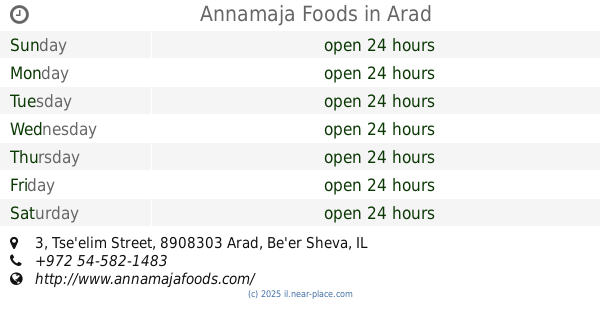
Annamaja Foods Home Restaurant
צאלים 3, ערד
Restaurant
read more
764 m
Annamaja Foods
Tse'elim Street 3, Arad
Restaurant
read more
764 m
Annamaja Foods Home Restaurant
Tse'elim Street 3, Arad
Restaurant
read more
1.52 km
Muza
מתחם תחנת הדלק אלון, כביש 31, ערד
Restaurant
read more
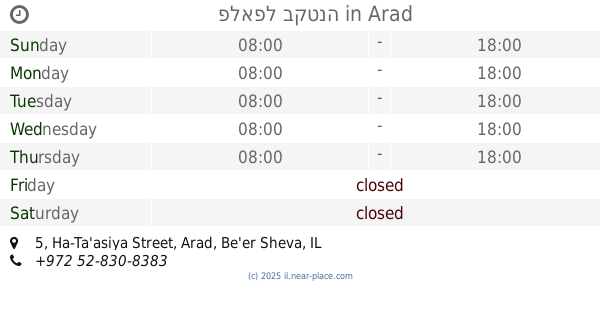
1.696 km
פלאפל בקטנה
Ha-Ta'asiya Street 5, Arad
Restaurant
read more
1.881 km
שווארמה סעיד
Arad
Restaurant
read more
1.881 km
שווארמה סעיד
ערד
Restaurant
read more
1.89 km
בית החומוס והפול
יהודה 32, ערד
Restaurant
read more
1.89 km
בית החומוס והפול
Yehuda Street 32, Arad
Restaurant
read more
1.925 km
פלאפל ציויס
Elazar Ben Ya'ir Street 35, Arad
Restaurant
read more
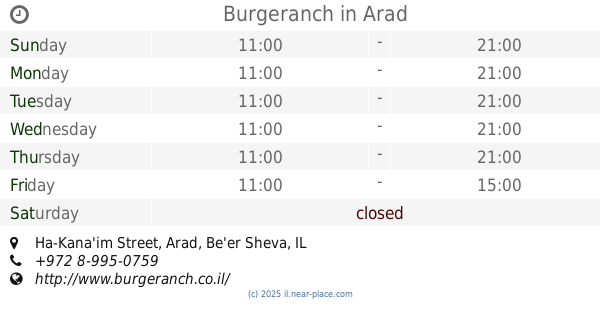
1.989 km
בורגראנץ'
27, Ha-Kana'im Street, Arad
Restaurant
read more
1.989 km
Burgeranch
27, Ha-Kana'im Street, Arad
Restaurant
read more
2.101 km
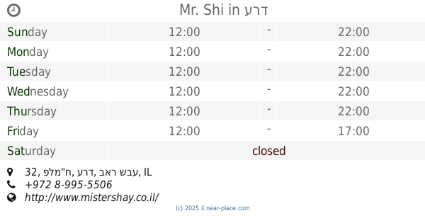
Mr. Shi
מרכזון נעורים, פלמ"ח 32, ערד
Restaurant
read more
2.534 km
מזנון הלוחם
תחנת דלק מעלה ערד, Arad
Restaurant
read more
2.534 km
מזנון הלוחם
תחנת דלק מעלה ערד, ערד
Restaurant
read more
2.539 km
אירוח ביתי אוכל בוכרי
Shaldag Street 12, Arad
Restaurant
read more
2.539 km
אירוח ביתי אוכל בוכרי
שלדג 12, ערד
Restaurant
read more
2.674 km
מדורת השבט
סיירים 3, ערד
Restaurant
read more
2.674 km
מדורת השבט
Sayarim Street 3, Arad
Restaurant
read more
2.846 km
כפרוצ'קה
Akhva Street 19, Arad
Restaurant
read more
2.846 km
כפרוצ'קה
אחווה 19, ערד
Restaurant
read more
16.727 km
מסעדת הר המצדה
הר המצדה ים המלח
Restaurant
read more
29.244 km
Ein Gedi Hotel Restaurant
Ein Gedi Maale, Arugot
Restaurant
read more
📑
all categories
Accounting
Administrative area level 1
Administrative area level 2
Airport
Amusement park
Aquarium
Art gallery
Atm
Bakery
Bank
Bar
Beauty salon
Bicycle store
Book store
Bowling alley
Bus station
Cafe
Campground
Car dealer
Car rental
Car repair
Car wash
Casino
Cemetery
Church
City hall
Clothing store
Colloquial area
Convenience store
Country
Courthouse
Dentist
Department store
Doctor
Electrician
Electronics store
Embassy
Establishment
Finance
Fire station
Florist
Food
Funeral home
Furniture store
Gas station
General contractor
Grocery or supermarket
Gym
Hair care
Hardware store
Health
Hindu Temple
Home goods store
Hospital
Insurance agency
Intersection
Jewelry store
Laundry
Lawyer
Library
Light rail station
Liquor store
Local government office
Locality
Locksmith
Lodging
Meal delivery
Meal takeaway
Mosque
Movie rental
Movie theater
Moving company
Museum
Natural feature
Neighborhood
Night club
Painter
Park
Parking
Pet store
Pharmacy
Physiotherapist
Place of worship
Plumber
Point of interest
Police
Political
Post office
Premise
Real estate agency
Restaurant
Roofing contractor
Route
Rv park, camping
School
Shoe store
Shopping mall
Spa
Stadium
Storage
Store
Subpremise
Subway station
Supermarket
Synagogue
Taxi stand
Train station
Transit station
Travel agency
University
Veterinary care
Zoo
administrative area level 3
administrative area level 4
sublocality level 1
↑