Restaurant nearby פסגת הפיצה
Israel
Restaurant nearby פסגת הפיצה
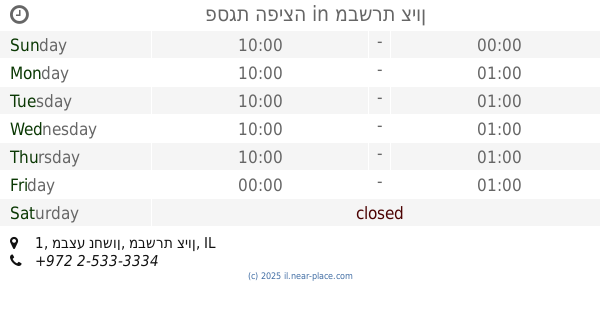
פסגת הפיצה
1, Mivtsa Nakhshon Street, Mevaseret Zion, IL Израиль
contacts phone
:
+972 2-533-3334
Latitude:
31.7946724
, Longitude:
35.1417876
larger map & directions
read more
nearest Restaurant
פסגת הפיצה
מבצע נחשון 1, מבשרת ציון
Restaurant
read more
125 m
Lucky dip
25 keren kayemat le'isreal
Restaurant
read more
301 m
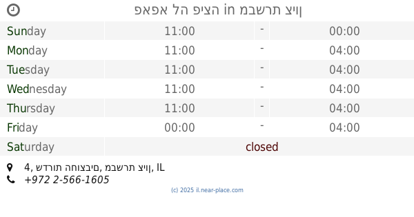
פאפא לה פיצה
שדרות החוצבים 4, מבשרת ציון
Restaurant
read more
337 m
פינתי
HaHotsvim Ave. 5, מבשרת ציון
Restaurant
read more
376 m
תבשילי אמא - אוכל מוכן
מצפה הבירה 1, מבשרת ציון
Restaurant
read more
419 m
לינק קסטל
היצירה 6, מבשרת ציון
Restaurant
read more
419 m
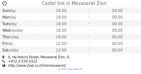
Castel link
Ha-Yetsira Street 6, Mevaseret Zion
Restaurant
read more
487 m
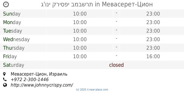
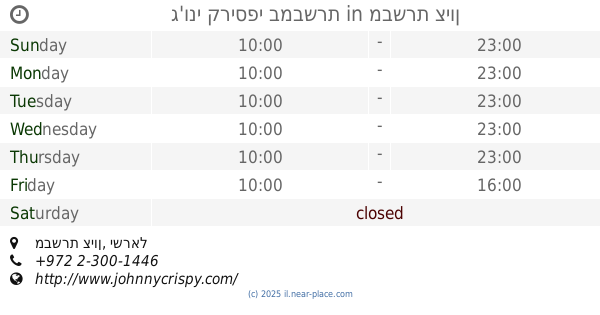
ג'וני קריספי במבשרת
Mevaseret Zion
Restaurant
read more
487 m
ג'וני קריספי במבשרת
מבשרת ציון
Restaurant
read more
489 m
מטעמי זוהר
כרמים 7, מבשרת ציון
Restaurant
read more
489 m
מטעמי זוהר
Kramim Street 7, Mevaseret Zion
Restaurant
read more
492 m
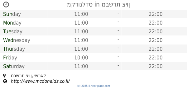
McDonald's
Mevaseret Zion
Restaurant
read more
492 m
מקדונלדס
מבשרת ציון
Restaurant
read more
783 m
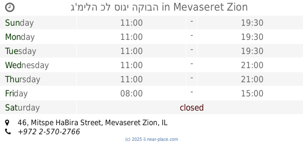
ג'מילה כל סוגי הקובה
Mitspe HaBira Street 46, Mevaseret Zion
Restaurant
read more
904 m
בייג'ינג מסעדה אסיאתית
קניון הראל, הראל, מבשרת ציון
Restaurant
read more
1.484 km
פסגת הפיצה
ורד 2, מבשרת ציון
Restaurant
read more
1.484 km
פסגת הפיצה
Vered Street 2, Mevaseret Zion
Restaurant
read more
1.484 km
Pizza Pizzliano
Vered Street 2, Mevaseret Zion
Restaurant
read more
1.603 km
אצה סושי בר מבשרת ציון
שדרות הראל 8, מבשרת ציון
Restaurant
read more
1.673 km
Naya Restaurant
Shvil Halulim, Beit Nekofa
Restaurant
read more
1.709 km
מפגש אייל
Rakefet Street 1, Mevaseret Zion
Restaurant
read more
1.807 km
Steam
HaEgoz Street 26, Jerusalem
Restaurant
read more
2.051 km
המסעדה הלבנונית
כביש השלום 88, אבו גוש
Restaurant
read more
2.348 km
בית קפה מסעדה דרך הגפן, בית זית
דרך הגפן 1, בית זית
Restaurant
read more
2.632 km
Muma מומה
Kiryat Anavim
Restaurant
read more
📑
all categories
Accounting
Administrative area level 1
Administrative area level 2
Airport
Amusement park
Aquarium
Art gallery
Atm
Bakery
Bank
Bar
Beauty salon
Bicycle store
Book store
Bowling alley
Bus station
Cafe
Campground
Car dealer
Car rental
Car repair
Car wash
Casino
Cemetery
Church
City hall
Clothing store
Colloquial area
Convenience store
Country
Courthouse
Dentist
Department store
Doctor
Electrician
Electronics store
Embassy
Establishment
Finance
Fire station
Florist
Food
Funeral home
Furniture store
Gas station
General contractor
Grocery or supermarket
Gym
Hair care
Hardware store
Health
Hindu Temple
Home goods store
Hospital
Insurance agency
Intersection
Jewelry store
Laundry
Lawyer
Library
Light rail station
Liquor store
Local government office
Locality
Locksmith
Lodging
Meal delivery
Meal takeaway
Mosque
Movie rental
Movie theater
Moving company
Museum
Natural feature
Neighborhood
Night club
Painter
Park
Parking
Pet store
Pharmacy
Physiotherapist
Place of worship
Plumber
Point of interest
Police
Political
Post office
Premise
Real estate agency
Restaurant
Roofing contractor
Route
Rv park, camping
School
Shoe store
Shopping mall
Spa
Stadium
Storage
Store
Subpremise
Subway station
Supermarket
Synagogue
Taxi stand
Train station
Transit station
Travel agency
University
Veterinary care
Zoo
administrative area level 3
administrative area level 4
sublocality level 1
↑