Restaurant nearby פאפא
Israel
Restaurant nearby פאפא
פאפא
משה אדרת, רמלה, רמלה, IL ישראל
contacts phone
:
+972 8-622-4837
Latitude:
31.931315
, Longitude:
34.890029
larger map & directions
read more
nearest Restaurant
126 m
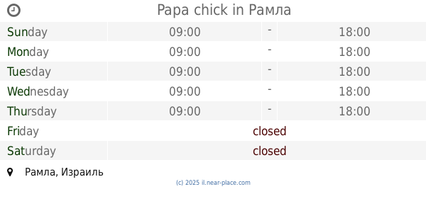
Papa chick
Ramla
Restaurant
read more
126 m
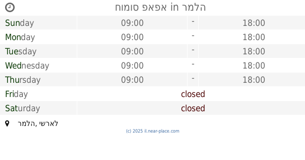
חומוס פאפא
רמלה
Restaurant
read more
137 m
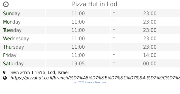
Pizza Hut
משה אדרת 1 רמלה, Lod
Restaurant
Meal delivery
Meal takeaway
Food
Point of interest
Establishment
read more
190 m
Burgeranch
קניון רמלוד, צופית 40, לוד
Restaurant
read more
210 m
Burgeranch
רמלוד, Tsofit 40, Ramla
Restaurant
Food
Point of interest
Establishment
read more
712 m
שולחן ערוך
10, Hayetzira, Ramla
Restaurant
read more
1.213 km
Pizza Shemesh
Sderot Ben Gurion 5, Lod
Restaurant
read more
1.315 km
McDonald's
Sderot Herzl 91, Ramla
Restaurant
read more
1.315 km
רשת מקדונלדס
שדרות הרצל 91, רמלה
Restaurant
read more
1.399 km
טאבון המזרח
4, Klausner Yosef Street, Ramla
Restaurant
read more
1.47 km
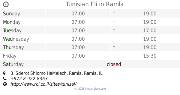
Tunisian Eli
Sderot Shlomo HaMelech 3, Ramla
Restaurant
read more
1.488 km
מהרג'ה
שדרות הרצל 87, רמלה
Restaurant
read more
1.496 km
בגט הזהב של גרשון ומזל
שדרות הרצל 87, רמלה
Restaurant
read more
1.647 km
בטטה מאצ'
שדרות הרצל 82, רמלה
Restaurant
read more
1.76 km
בורקס הנשיא
Ha-Nasi Street 1, Lod
Restaurant
read more
1.76 km
בורקס הנשיא
1, Ha-Nasi Street, Lod
Restaurant
read more
1.839 km
חומוסיית סאמר
דני מס 1, רמלה
Restaurant
read more
1.839 km
Hummus place Samer
Dani Mas Street 1, Ramla
Restaurant
read more
1.945 km
Falafel end of the road
72210, Ha-Hagana Street 2, Ramla
Restaurant
read more
1.973 km
מייק בורגר
שדרות הרצל 43, רמלה
Restaurant
read more
1.994 km
שקשוקה אנט חדש
Khayim Asher Street 2, Ramla
Restaurant
read more
2.014 km
פרנקו גריל-בר
הנשיא 19, לוד
Restaurant
read more
2.016 km
מסעדת חליל
קהילת דטרויט 6, רמלה
Restaurant
read more
2.196 km
الحار تحتا
Khevron Street, Ramla
Restaurant
read more
2.196 km
الحار تحتا
חברון, רמלה
Restaurant
read more
📑
all categories
Accounting
Administrative area level 1
Administrative area level 2
Airport
Amusement park
Aquarium
Art gallery
Atm
Bakery
Bank
Bar
Beauty salon
Bicycle store
Book store
Bowling alley
Bus station
Cafe
Campground
Car dealer
Car rental
Car repair
Car wash
Casino
Cemetery
Church
City hall
Clothing store
Colloquial area
Convenience store
Country
Courthouse
Dentist
Department store
Doctor
Electrician
Electronics store
Embassy
Establishment
Finance
Fire station
Florist
Food
Funeral home
Furniture store
Gas station
General contractor
Grocery or supermarket
Gym
Hair care
Hardware store
Health
Hindu Temple
Home goods store
Hospital
Insurance agency
Intersection
Jewelry store
Laundry
Lawyer
Library
Light rail station
Liquor store
Local government office
Locality
Locksmith
Lodging
Meal delivery
Meal takeaway
Mosque
Movie rental
Movie theater
Moving company
Museum
Natural feature
Neighborhood
Night club
Painter
Park
Parking
Pet store
Pharmacy
Physiotherapist
Place of worship
Plumber
Point of interest
Police
Political
Post office
Premise
Real estate agency
Restaurant
Roofing contractor
Route
Rv park, camping
School
Shoe store
Shopping mall
Spa
Stadium
Storage
Store
Subpremise
Subway station
Supermarket
Synagogue
Taxi stand
Train station
Transit station
Travel agency
University
Veterinary care
Zoo
administrative area level 3
administrative area level 4
sublocality level 1
↑